October - December 2003
October - December 2003 |
||||||||
|
|
||||||||
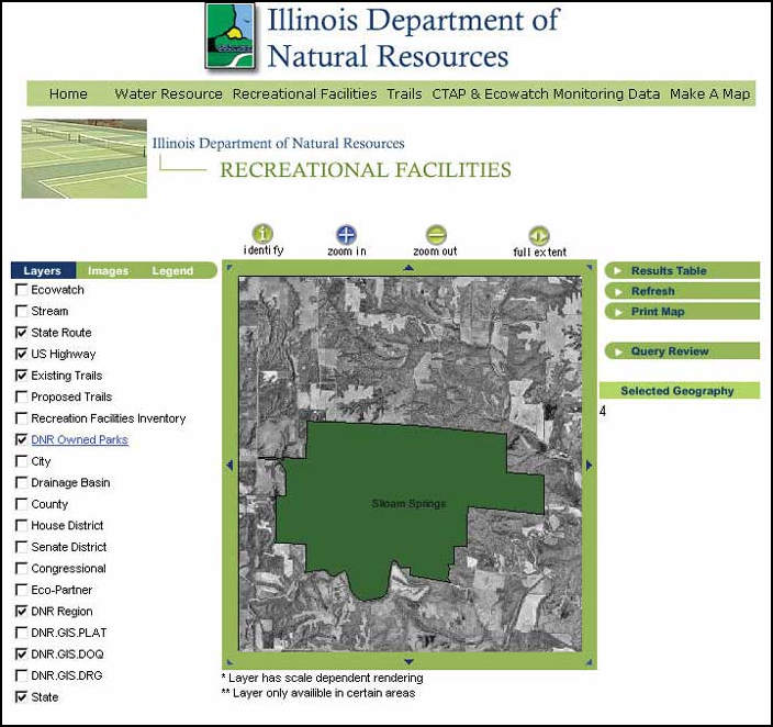
The Illinois Department of Natural Resources (IDNR) manages, protects, and helps sustain Illinois' natural and cultural resources; provides resource-compatible recreational opportunities; and promotes natural resource-related public safety, education, and science. IDNR supports a broad range of programs that monitor and manage natural, cultural, and recreational resources. As a result of these activities, the offices and divisions administering programs and projects collected valuable resource data. However, these datasets were maintained in local databases and duplicated to allow data sharing. Esri business partner GIS Solutions, Inc. (GSI), developed a Web-based application for IDNR that brought program and project data together in one centralized location. This intuitive and simple ArcIMS application can be used by any IDNR employee and requires no training. It presents users with program-specific query options and an overall map function. As IDNR augments the application, more programs will be added. The programs initially developed deal with monitoring, recreational facilities, trails, and initiatives within the Office of Water Resources. IDNR program data is stored in a variety of file types and formats including Esri shapefiles and coverages, Microsoft Access databases, digital orthophoto quadrangles (DOQs), digital raster graphics (DRGs), plat maps, and MrSID and TIFF format images. Wizard-like query pages step users through dynamic and interactive queries of these datasets. Users can create maps and view aerial photography and raster images with specific spatial and tabular data in one easy-to-use Web application. Building the ApplicationThe application was developed using Active Server Pages (ASP), Visual Basic Script, JavaScript, and SQL. The IDNR Web application uses a multitier (or n-tier) architecture in a distributed environment that consists of three primary tiers-data store, business logic, and presentation. Within each primary tier, there may be additional subtiers. The data store tier components include the network connection to the database servers (i.e., the IDNR network), Microsoft SQL Server 2000, ActiveX Data Objects (ADO), and database and ArcSDE servers. The business logic tier components are listed in Figure 1. The presentation tier components include the user's Web browser and the files that make up the IDNR Web application. Figure 1
Imagery ManagementThree main types of imagery—DOQs, DRGs, and plat maps—are stored using ArcSDE with a Microsoft SQL Server database. Mosaicking, performed using ERDAS IMAGINE 8.6, merged individual images into one larger data layer to improve application speed. Approximately 4,400 MrSID DOQ images, covering the state of Illinois, were stored in an image catalog in ArcSDE. A total of 1,279 DRG images was mosaicked. Pyramid layers and statistics were built and the resulting statewide image stored in ArcSDE. More than 100 county plat map images, originally created by the Rockford Map Publishing Company, were mosaicked and stored in ArcSDE using JPEG compression. These image management strategies optimized image retrieval and maintenance. Final ResultPrior to the development and implementation of this ArcIMS application, data collected by IDNR programs was stored in disparate locations in various formats and duplicated for sharing. Today, users can view, query, and share information for various programs and projects within IDNR, and data is centrally served across the Intranet using the ArcIMS application. For additional information on the project, contact Sheryl Oliver, GIS Coordinator |