Fall 2009
Fall 2009 |
||||||||
|
|
||||||||
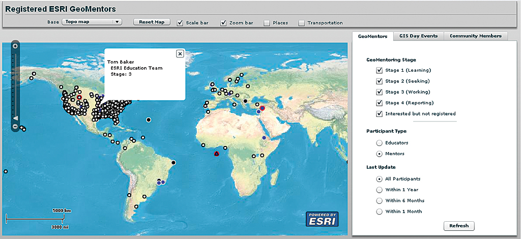
Although geospatial information continues to play a larger and more critical role in analyzing conditions and making decisions in many professions, the level of geographic knowledge and spatial thinking skills of students continues to fall. The GeoMentoring Program goes beyond an annual event that heightens awareness of the importance of geographic knowledge and establishes a resource for improving this type of knowledge all year long. "The rate of geoliteracy in the United States—meaning the number of people who can synthesize geographic information from a variety of sources and draw a sound conclusion—is frighteningly low," said Daniel C. Edelson, vice president for education, National Geographic Society. "If it is allowed to continue, the inability of most Americans to do even basic analysis of geographic information will have a profound impact on our ability to compete economically, maintain our security, and sustain our environment in coming decades." What Is the GeoMentoring Program?The GeoMentoring program is a global answer to this growing need for geoliteracy. Part resource center and part matchmaking service, the GeoMentoring program helps people who know and use geography in their professional lives join forces with educators who want to incorporate activities that teach geography and geospatial technology into the daily curriculum of students from elementary through college levels. A key part of the program is the GeoMentor Web site, which has tools for seeking a partner, finding activities, acquiring resources, and sharing stories. The GeoMentoring program was announced by its cosponsors, the National Geographic Society (NGS) and Esri, on July 13, 2009, at the Plenary Session of Esri's 29th Annual International User Conference. During the conference, Charlie Fitzpatrick, who is leading the GeoMentoring program for Esri, and Anne Haywood of the National Geographic Society made several presentations about the program that elicited a lively response from attendees. More than 900 people at the conference indicated their interest in the program by having their conference badges scanned so they could be sent additional information. Who Can Be a GeoMentor?
People from any occupational field who use geography and recognize its importance are welcome to participate in the program. GeoMentors adopt a classroom or run an after-school program that helps both teachers and students see the world around them—at scales large and small—geographically. Activities GeoMentors might engage in range from exercises for younger students that involve paper maps and crayons to long-term GIS projects for older students that benefit the community. What Does It Take to Be a GeoMentor? There are four important qualities that a potential GeoMentor should possess: vision, commitment, willingness to learn and share, and a sense of excitement. Vision GeoMentors need to share the belief that youth are the future and that understanding geography will help them (our future leaders) make better decisions. Commitment While this program carries on and expands the spirit of GIS Day, GeoMentoring is a relationship, not an event. There is no minimum number of sessions or activities required, but the partnership between the GeoMentor and the educator needs time to develop. Willingness to Learn and Share GeoMentors listen to the educators they are working with to learn—specifically—what they need to support geographic learning in their classrooms. Excitement GeoMentors need to remember why they became interested in geography in the first place so they can convey this excitement to students and teachers. What Do GeoMentors Do?The only thing a GeoMentor must do is get to know the needs of the educator-partner. The list of activities a GeoMentor can do is long, varied, and constantly growing. The needs of the educational partner will largely determine which activities an individual GeoMentor undertakes. These activities will evolve with the relationship. These suggestions are just a few examples:
More suggested activities are listed on the GeoMentoring.org (edcommunity.esri.com/geomentor) Web site under Activities. Many more ideas can be found on the Web sites linked to the GeoMentoring site. How Do I Get Involved?The first step in becoming a GeoMentor is visiting the GeoMentoring.org Web site (edcommunity.esri.com/geomentor) and registering so you can be contacted by potential Mentees. This process requires nothing more than an Esri Global ID and lets you indicate how you wish to be contacted. Once completed, your location will be placed on the site's map so educational partners near you can contact you through the GeoMentoring.org site. |