Fall 2009
Fall 2009 |
||||||||
|
|
||||||||
This movement has support at the highest levels. U.S. President Barrack Obama has said, "We must use all available technologies and methods to open up the federal government, creating a new level of transparency to change the way business is conducted in Washington, and giving Americans the chance to participate in government deliberations and decision making in ways that were not possible only a few years ago." At the recent Gov 2.0 Summit sponsored by O'Reilly Media and TechWeb and held in Washington, D.C., September 9�10, 2009, it was clear that GIS was the technology best suited for making government more inclusive and responsive. Application after application showed the value and need for real-time location-relevant data. In the words of Andrew Turner, CTO at FortiusOne and a participant in the event, "Geography allows citizens to have one common view of government." This is not news to GIS users. Most of the information that governments deal with has a strong connection to place—property taxes are assessed by parcel, garbage trucks are routed on city streets, and polling place locations are related to the home addresses of voters. GIS has evolved from a tool for managing projects to a framework that governments use for understanding and responding to problems on scales ranging from local to global. Not only do governments benefit from considering geographic factors in the decision-making process, but these agencies also use the geographic framework supplied by GIS for organizing, analyzing, visualizing, and displaying all types of data that are germane to solving a problem, making a policy, or improving a process. Making Government More AvailableUsing the Web as a means of improving the responsiveness of government is not new either. In its first iteration, the marriage of the Web and government produced e-Government, or e-gov. Designed to improve the level and quality of services that government provided citizens, businesses, and other government agencies, government Web sites quickly evolved from billboards with phone numbers and mission statements to more interactive sites with querying capabilities, online forms, and payment capabilities.
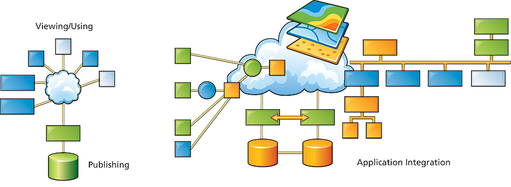
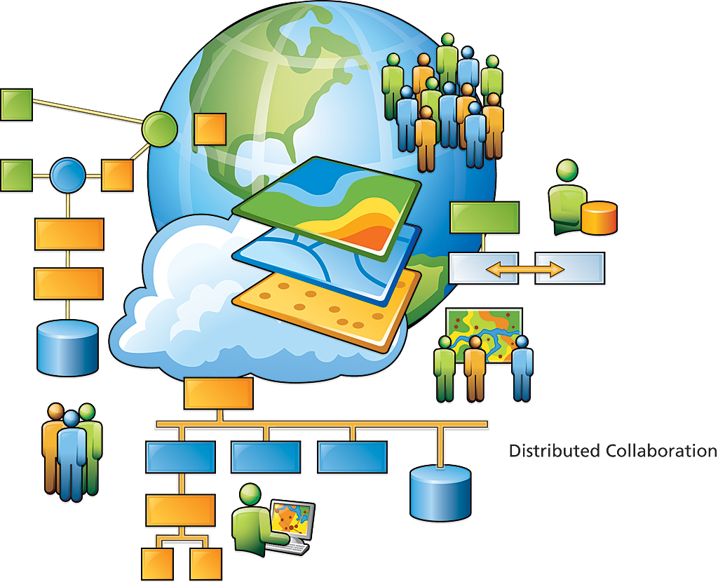
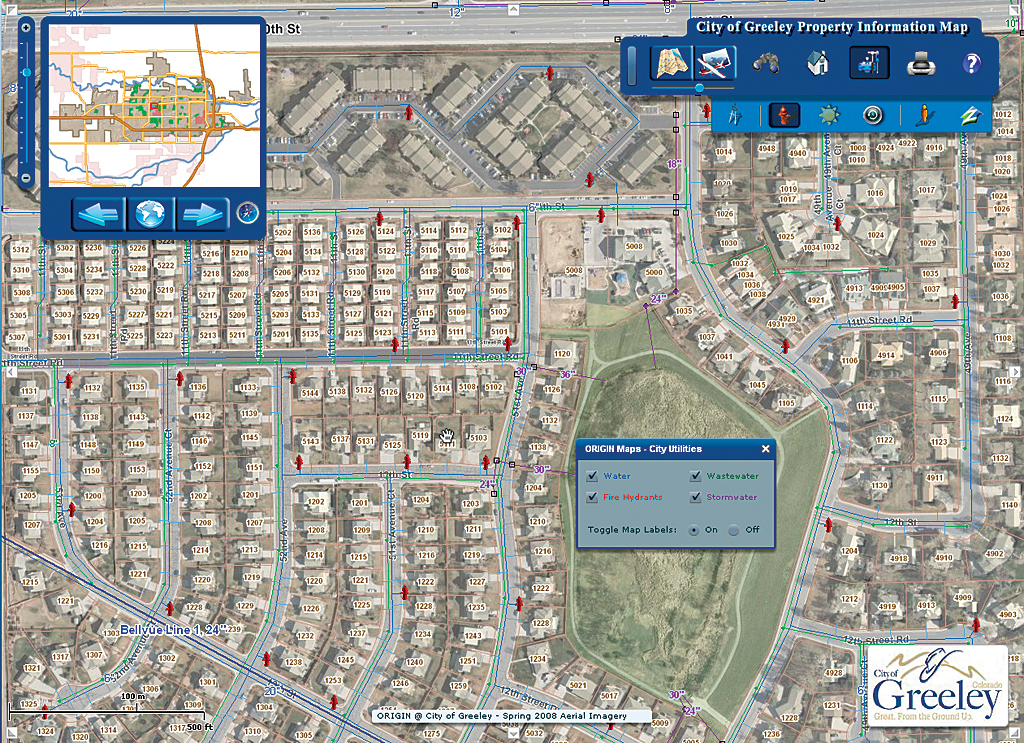
However, providing an intuitive interface for accessing information proved challenging. Governments turned to a relatively new technology that had been used internally for improving processes through organizing and managing information by its geographic location: GIS. In the mid-1990s, in the midst of what has come to be called Web 1.0, online map services were adopted as a way for governments to supply maps on demand for many topics—planning, school district locations, legislative districts, and trash service areas. A single server broadcast map services to many clients. On the Web, GIS became a tool for collaboration, communication, and service that streamlined interactions between the government and its citizens, businesses, and other government agencies. From a business operations standpoint, Web GIS frees staff from repeatedly answering the same questions about where a polling place is located or which day trash is picked up and allows them to work on other tasks while shortening the time needed to accomplish processes. From a customer service standpoint, Web GIS provides specific information; is available 24 hours a day, seven days a week; and does not require a visit to a government office. The Impact of Web 2.0 on GISThe Web has been evolving from a static, published media to the dynamic, database-driven, collaborative environment now referred to as Web 2.0. Applications for Web 2.0 recognize that value is added by users. The Web functions powerfully because it is both decentralized and collaborative. In the Web 2.0 environment, there are many new ways to use GIS that empower users and take advantage of the collective intelligence of the Web—collaborative computing, integration of user-contributed content, mashups, and shared distributed data management—to name a few. Distributed global GIS has been dubbed the GeoWeb by Esri president Jack Dangermond and described as "a large, widespread, distributed collaboration of knowledge and discovery that promotes and sustains worldwide sharing and interoperability." Instead of providing wide access to a single source of data, the GeoWeb is bringing together vast stores of authoritative, transactional data, much of it maintained by government, and the geospatial services that can be used with it to create new information. Focused server-side applications supply the benefits of geospatial tools, data, and processes to end users who may be unaware they are using GIS. In this new development environment, Web developers can incorporate GIS functionality in Web applications. ArcGIS Server supplies a strong development environment that includes .NET and Java APIs and hosted mapping APIs for JavaScript, Adobe Flex, and Microsoft Silverlight. This has greatly increased the number of Web applications that use GIS and made the collaboration tools in GIS available to a much larger audience. Many kinds of clients—smart clients, Web clients, and mobile clients—can consume the data, information, and visualizations produced. Interactive GeoWeb applications are already providing greater access to government data and enhancing government services. The City of Greeley, Colorado, began using GIS in its water and sewer department in 1989. In the intervening decades, GIS use spread to almost every department in the city. To better serve its citizens and more efficiently use its staff, Greeley developed an intuitive and responsive Web application that provides the general public with quick access to a wealth of information about any parcel in the city—from zoning information to school districts to the location of the nearest fire hydrant. The data, maintained by the city, is current and authoritative. Before this application was developed, city planners were spending between three and four hours each day on the phone providing the same information that is now delivered in seconds by this Web application. Talking about GIS and Gov 2.0Dangermond was one of more than 80 business, government, and leaders who spoke at the Gov 2.0 Summit. In his presentation, "Geoenabling Gov 2.0," he noted that geospatial data is pervasive at all levels of government—not just in the U.S. but all around the world. This data has been used in many integrated applications that improve planning, management, and decision making. "Actually, as you look across government, I would assert that it is a kind of new information infrastructure," he observed. Data sharing has been critical to the success of GIS, and the federal government has led the way. Many agencies, such as the U.S. Census Bureau and the U.S. Geological Survey, consider data sharing part of their mission. While this imperative has led to the creation of data clearinghouses that have improved access to data, it hasn't created a geospatial framework. A national framework is needed for sharing government's authoritative data sources. Currently, ftp download of data is a barrier to many potential users of geospatial information. Removing this impediment requires moving from data file sharing to shared services or geoservices. Combined with easy-to-use clients, deploying geoservices on a large scale would open access to this data to many new users and applications. These services should be "RESTful" and easily discovered, support open standards, and be amenable to being mashed up with simple clients and APIs available to everyone. The Geoservices Explosion
Widespread development of geoservices would leverage government's huge investments in data and connect government to citizen and government to government. The result would be a geospatial framework for Gov 2.0. In characterizing the effect of geoservices, Dangermond said, "Exposing these services will bring about as much change as GIS itself has brought." Existing services could be combined into new services. This would remove impediments between organizations currently using geospatial data and allow them to work in a loosely coupled environment that favors collaborating and encourages synergies. Examples EmergingApplications already developed for emergency response and military operations demonstrate the viability and value of loosely coupled environments for providing a common operational picture (COP). The Virginia Department of Emergency Management (VDEM) uses Virginia Interoperability Picture for Emergency Response (VIPER) to protect the commonwealth's people and property. VIPER supplies a new level of situational awareness by combining data supplied by environmental sensors and gathered from VDEM's crisis management system and other external systems with traditional GIS layers that provide location context. This system gives a COP to Virginia Emergency Operations Center staff and allied agencies involved in emergency events. Information can be visualized, analyzed, and queried by staff members who are not GIS specialists. It is anticipated that data from VIPER will be shared with other state and local government partners using GeoRSS, .xml, and other widely accepted data formats. The Foundation ExistsEsri has been evolving ArcGIS as a complete platform for geoenabling organizations. ArcGIS Desktop provides tools for authoring maps, managing data, building analytic models, and generating metadata. ArcGIS Server publishes that data to a variety of clients, from Web browsers and mobile devices to desktop GIS applications. This has enabled hundreds of government organizations to make data available to businesses, other government agencies, and individuals. With the creation of ArcGIS Online, Esri moved from being primarily a software company to a software-plus-services company. Each copy of ArcGIS includes free access to millions of dollars of content services—basemaps, imagery, demographic data, and other resources—that are immediately available from ArcGIS Online. Additional premium content is available from partners such as Microsoft, DigitalGlobe, and GeoEye on a subscription basis. ArcGIS Explorer is a GIS visualization tool for intuitively exploring, sharing, and presenting geographic information. It can combine locally created data with the continually updated basemaps and layers, shared maps, and tools from ArcGIS Online. Toward a Societal GISAs governments have been demonstrating for 40 years, applying geography improves the decision-making processes by addressing problems and evaluating proposed solutions in a holistic, comprehensive, systematic, analytic, and visual manner. With GIS, the analysis of problems can have greater depth, as many layers of data relating to the physical and cultural world can be considered together. GIS is a platform for optimizing systems, whether the system is a utility network, transportation system, or government. While the the use of GIS by the government, e-Government, GIS applications on the Web, and Web 2.0 are not new, the urgent need to find new ways to deal with old problems combined with increasing geospatial awareness and the desire on the part of government to pursue new technology are new. The ArcGIS platform—combined not only with the government's authoritative data but also its high-quality maps, visualizations, spatial analysis, models, and other rich applications made available as geoservices—would lead to the creation of government-to-citizen, government-to-business, government-to-education, and government-to-government applications that would integrate all levels of government and support open access, collaboration, and transparency. |