Fall 2009
Fall 2009 |
||||||||
|
|
||||||||
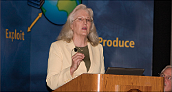
"It [remote sensing] has its origins in the defense industry. However, for years there has been a misconnect between technology providers and problem solvers." Green explained why she sees that situation coming to an end in her address, Remote Sensing Comes of Age. Green is the immediate past president of the American Society for Photogrammetry and Remote Sensing and president of Kass Green & Associates, a firm that consults on geospatial strategy. In numerous articles and book chapters, she has advocated for the integration of GIS and remote sensing to improve environmental and policy analysis. Twenty years ago, Green said she couldn't imagine using GIS software without remote sensing and vice versa. The two have an intimate and long-standing relationship. Many GIS practitioners don't appreciate the contributions of remote sensing to GIS in the past and its tremendous potential contributions. Green said the perception of remotely sensed data needs to change. "We need to see it more as a database of numbers and less as a pretty picture." Ongoing developments in the remote-sensing industry and in GIS technology have made classification a more automated process and limited the time between the capture and use of imagery. GIS practitioners now have more imagery and imagery that is more current and consistently available to them than ever before. In addition to imagery supplied by new commercial satellites that offer higher resolution, more spectral bands, and short revisit periods, some imagery, from programs such as Landsat and the National Agriculture Imagery Program (NAIP), is available at little or no cost. "However, with all this progress, some problems still remain," said Green. Imagery is still hard to use and large imagery files are still cumbersome. Perhaps more worrisome is that the United States is still uncommitted to continuous observation. Now more than ever, there is a need to integrate GIS and remote sensing to handle the challenges of making policy and locating and evaluating resources. This requires making data more accessible to more people more quickly. In closing, Green urged attendees to effect change. "You have the education and experience that empower you to make a difference. Use the data and software at your fingertips to deliver truth, not conjecture. We don't get a second chance to do this right." |