Fall 2009
Fall 2009 |
||||||||
|
|
||||||||
The goal of the IMPETUS project is the development of management options for different components of the hydrological cycle using the SDSS tools. Because decision making requires an exhaustive knowledge of the processes, driving forces, possibilities, and stakeholders, ArcGIS Engine was used in computer-based SDSSs to handle huge amounts of data and provide visually attractive, reliable, and convincing displays of that data to users. Functionality developed for three of the ArcGIS Engine-based SDSSs will be discussed. Explicitly designed to provide a decision-making environment that enables the analysis of geographic information to be carried out in a flexible manner, SDSSs help researchers and managers make decisions. Modern computer-based SDSSs are comprehensive and complex systems that compile individual decision steps into an overall software structure and include spatial data, quantitative, and/or qualitative models with expert knowledge. SDSSs can be customized to the needs of individual users based on a given logical decision tree that has been predefined by users and developers during the design process. These systems are developed based on predefined, multifarious logical decision trees focused on a specific question. In the case of the IMPETUS project, that question was how to create an integrated approach to the efficient management of scarce water resources in West Africa. By providing users with access to large amounts of significant spatial data, SDSSs are powerful problem-solving tools that often use a GIS component to add spatial analysis functionality. The ability of GIS to layer spatial and attribute data distinguishes this technology from many other decision support systems. Materials and Methods
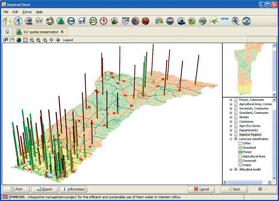
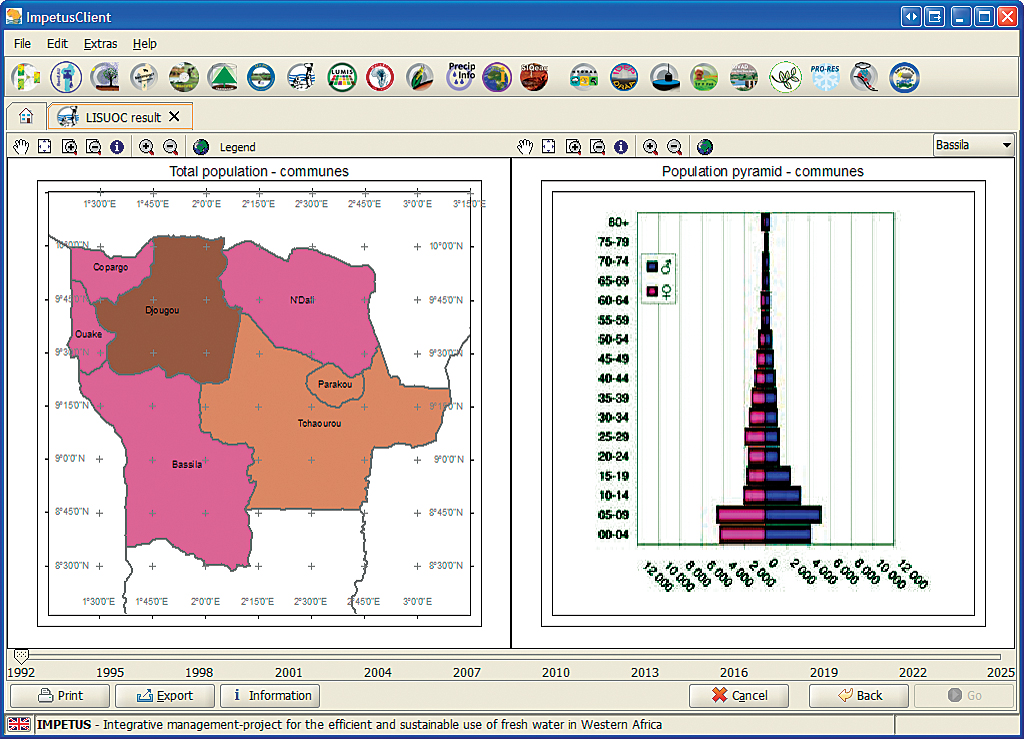
To include GIS and remote-sensing functionalities in the SDSSs, the Esri developer library for ArcGIS Engine 9.2 was used to program these systems. With ArcGIS Engine, a software developer can implement spatial analysis functions within computer-based spatial decision tools. To execute these SDSSs, the Java Runtime Environment (JRE) and ArcGIS Engine must be installed on the computer. The SDSSs were developed using the Eclipse software development kit (SDK). During the programming process, specific ArcGIS Engine components and other libraries, such as the POI-HSSF components furnished by Jakarta POI Java API for reading Microsoft Excel '97 file formats, were used in addition to standard JavaBeans [the reusable software components of the Java 2 platform]. Alphanumeric data and rasters, vector, and other geodata for individual SDSSs are stored in ArcGIS 9.2 file-based geodatabases. Resulting ToolsThe ArcGISDoubleMapPanel was specially developed for environmental and social research, which requires the ability to compare different scenarios. With the help of two PageLayoutBeans, two feature layers with different attributes can be displayed and the user can intuitively compare these attributes. A Java slider (JSlider) component located below the two maps allows the user to view changes in the scenario over time. This slider has access to multitemporal feature layers and provides different time increments. Alternatively, the ArcGISDoubleMapPanel displays feature data classified by only one attribute. The user is able to compare two maps or even a map and a static figure, like an age pyramid, visually. In the latter case, ArcGISDoubleMapPanel provides an easy way to give the user more detailed information, for example, population information for specific communes in the research area for a selected year. Using a specific processor that accesses the specific time step of the layer, both PageLayoutBeans of the ArcGISDoubleMapPanel are updated during run time. Based on the classification applied to the map, layers change color or age pyramids change shape in response to movement of the time slider. The 3D-ArcGISScenePanel was developed for another SDSS. It is designed to optimize production systems under climate change and visualize eco-volume data within tropical agricultural science. Besides the use of the common ArcGIS tools provided by ArcGIS Engine, this graphical user interface (GUI) provides the user with the opportunity to rotate the 3D map in all directions and get a useful overview of a certain region of interest. In addition, specific 3D objects are included. Hence, within the IMPETUS client, three-dimensional vector and raster layers can be displayed and analyzed with the help of the 3D-ArcGISScenePanel.
In the research area of the Upper Ou�m� Valley in Benin, more than 2,000 wells were digitized and included in a comprehensive geodatabase. With the help of Esri ArcGIS Engine technology, ArcGISMapPanel was developed, which allows the user to visualize a one-to-many SQL-DB selection. This panel is a comprehensive map visualizing GUI, which includes a MapPanel, an overview map, and GIS tools. By using the ArcGISMapPanel and its specific functionalities, it is possible to select specific wells in the geodatabase based on a chosen location, visualize the data in a developed map panel, and save the selection in a vector file. ConclusionArcGIS functionality can be incorporated into modern SDSSs using ArcGIS Engine with Java, an object-oriented programming language. SDSS developers can code advanced computer-based SDSS tools that are designed and developed to answer a specific question based on the user requirements. These three tools—ArcGISDoubleMapPanel, 3D-ArcGISScenePanel, and ArcGISMapPanel—as well as the overall ArcGIS Engine-based development for the IMPETUS client show that Esri's technology is feasible and very useful for SDSSs. For more information, contact Dr. Rainer Laudien About the AuthorsDr. Rainer Laudien is a postdoctoral research fellow in the Bundesministerium f�r Bildung und Forschung/Federal German Ministry of Education and Research (BMBF) Project IMPETUS Westafrika at the University of Cologne. His major field of work is software development for spatial decision support systems by using GIS, model, and remote-sensing data. Sebastian Brocks is a student assistant in the BMBF Project IMPETUS Westafrika at the University of Cologne. His major interest is software development, specifically integrating ArcGIS Engine components in custom applications. Stefan Weyler is a student assistant in the BMBF Project IMPETUS Westafrika at the University of Cologne. His major interests are development studies with a thematic focus on socioeconomic processes and regionally on sub-Saharan Africa. Alexander Christmann is a student assistant in the BMBF Project IMPETUS Westafrika at the University of Cologne, studying at the Faculty of Computer Science and Engineering Science of the Cologne University of Applied Sciences. His major interests are software engineering, visualization of complex systems, and algorithms. Niklas K�hn has studied computer science and geography at the University of Cologne. In 2008, he finished his Magister thesis at Lufthansa Technik in Hamburg. His major interest is the interface between electronically processed information and human users. Dr. Georg Bareth, a professor at the University of Cologne, heads the GIS and Remote Sensing Group in the Department of Geography. His major research interests are in mobile GIS applications and location-based services, GIS-based regionalization of N- and C-dynamics in ecosystems; analysis of multispectral, hyperspectral, and radar data for land-use mapping; the application of GIS and remote sensing for agricultural purposes; terrestrial laser scanning; and geographic databases. AcknowledgmentsDevelopment and implementation of the SDSSs are carried out for the interdisciplinary research project IMPETUS. For more information, visit www.impetus.uni-koeln.de. The programmed systems are implemented in the Impetus Spatial Decision Support System (ISDSS), a Java/XML-based framework. This study is part of that interdisciplinary scientific project and is supported by the BMBF under grant No. 01 LW 06001A and 01 LW 06001B as well as by the Ministry of Innovation, Science, Research and Technology of the federal state of Northrhine-Westfalia under grant No. 313-21200200. ReferencesChristoph, M., A. Fink, B. Diekkr�ger, S. Giertz, B. Reichert, and P. Speth. "IMPETUS: Implementing HELP in the Upper Ou�m� Basin." Water South Africa, Vol. 34, No. 4, 2008. Densham, P. J. 1991. "Spatial Decision Support Systems." In: D. J. Maguire, M. F. Goodchild, and D. W. Rhind (eds.), Geographical Information Systems, Volume 1: Principles, pp. 403�412. Longman. Enders, A., R. Laudien, and R. Hoffmann. "Spatial Decision Support Systems." In: A. H. Fink and B. Reichert (eds.): Integratives Management-Projekt f�r einen Effizienten und Tragf�higen Umgang mit S��wasser in Westafrika: Fallstudien f�r ausgew�hlte Flusseinzugsgebiete in unterschiedlichen Klimazonen, Siebter Zwischenbericht: 7�21, http://www.impetus.uni-koeln.de/content/download/ZB2006/IMPETUS_Zwischenbericht_2006.pdf, 2007. McCarthy, J., P. Graniero, and S. Rozic. "An Integrated GIS-Expert System Framework for Live Hazard Monitoring and Detection." Sensors, 8: 830�846, 2008. Mennecke, B., M. Crossland, and B. Killingsworth. "Is a map more than a picture? The Role of SDSS Technology, Subject Characteristics, and Problem Complexity on Map Reading and Problem Solving." MIS Quarterly, 4: 601�604, 625�629, 2000. Meyer, B., and R. Grabaum. "MULBO: Model Framework for Multicriteria Landscape Assessment and Optimisation. A Support System for Spatial Land Use Decisions." Landscape Research, 2: 155�179, 2008. Speth, P., B. Diekkr�ger, M. Christoph, and A. Jaeger. "IMPETUS West Africa—An Integrated Approach to the Efficient Management of Scarce Water Resources in West Africa.": GLOW—Global Change in the Hydrological Cycle, Status Report 2005: 86�94, 2005. |