October - December 2004
October - December 2004 |
||||||||
|
|
||||||||
When the telecommunications services monopoly in Brazil ended in 1998, telecom companies needed aggressive strategies for coping with market pressures in a new competitive environment. These companies sought technologies that would allow them to offer a variety of services that would attract clients while meeting the goals established by the government's regulatory bodies. Brasil Telecom is one of these companies. It owns the Region II concession area, which provides wireline telephone service for 23 percent of Brazil's population. Brasil Telecom's service area covers approximately 2.8 million square kilometers or approximately 33 percent of Brazil. This area encompasses nine of Brazil's 26 states—Acre, Rond�nia, Mato Grosso, Mato Grosso do Sul, Tocantins, Goi�s, Santa Catarina, Paran�, and Rio Grande do Sul-in addition to the federal district. The goal of Brasil Telecom's GIS project was to incorporate geotechnology into the analysis of the telecommunications market in Brazil. Specifically, this would include mapping the Brazilian telephone market with an emphasis on Brasil Telecom's service area and providing demand analyses for municipal and urban markets. GIS would also be used for acquiring new clients and generating new products targeted at specific audiences. By building a geographic database and associating socioeconomic information, Brasil Telecom would be able to study the market's structure. Decision Making FrameworkThe geographic analysis environment for Brasil Telecom was designed to meet the needs of various departments in the company, be incorporated in a variety of business tasks, and integrate different technologies. GIS analysis tools would be developed for the Marketing, IT, and Engineering Departments and connect existing technologies to provide a better framework for decision making. The project was developed jointly with Imagem Geosistemas E Com�rcio Ltda., an Esri international distributor. Imagem supplied the geographic database, provided training, and assisted in structuring and implementing GIS in the company. ArcGIS was used for map editing, analysis, and plotting while ArcIMS was used for disseminating data within the company via the Web. Combining Geography and Socioeconomic DataThe project used data for municipal intraurban areas and georeferenced social, income, education, consumption, industrial activity, and urban infrastructure variables that were grouped by municipality. These analyses helped define strategies and identify investment opportunities. To reduce costs and optimize planning for both engineering and marketing activities, municipalities were classified according to infrastructure potential and investment capabilities.
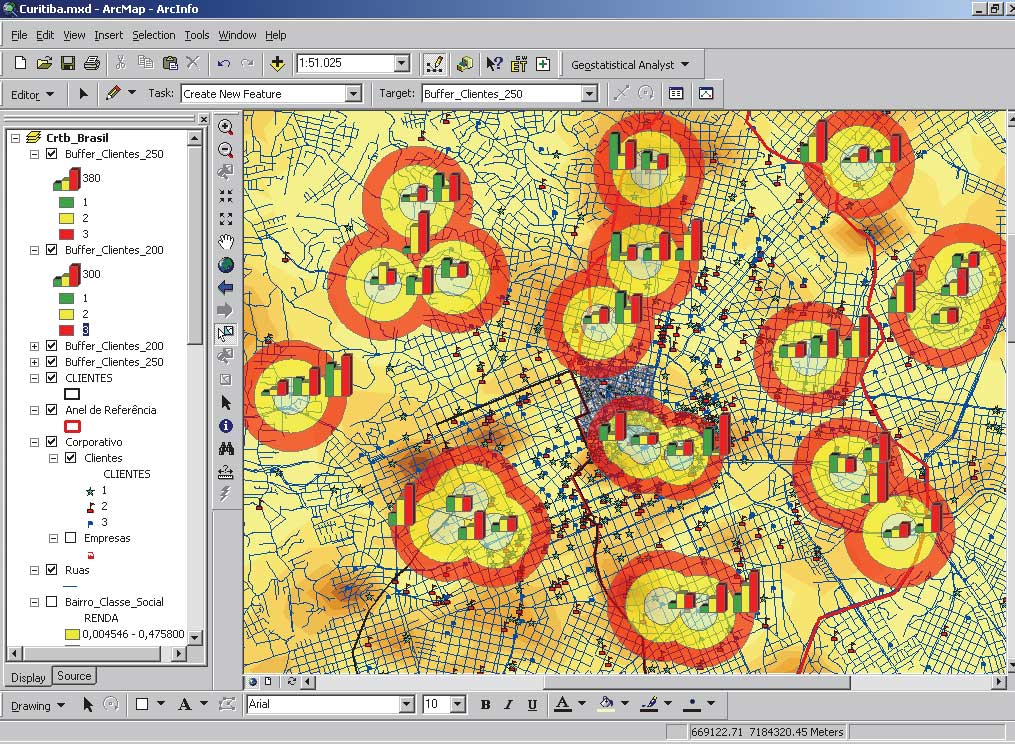
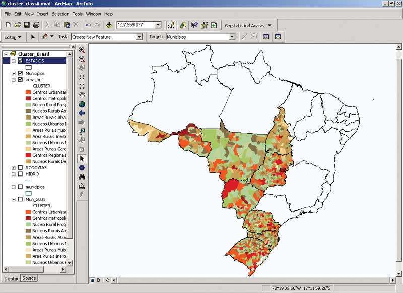
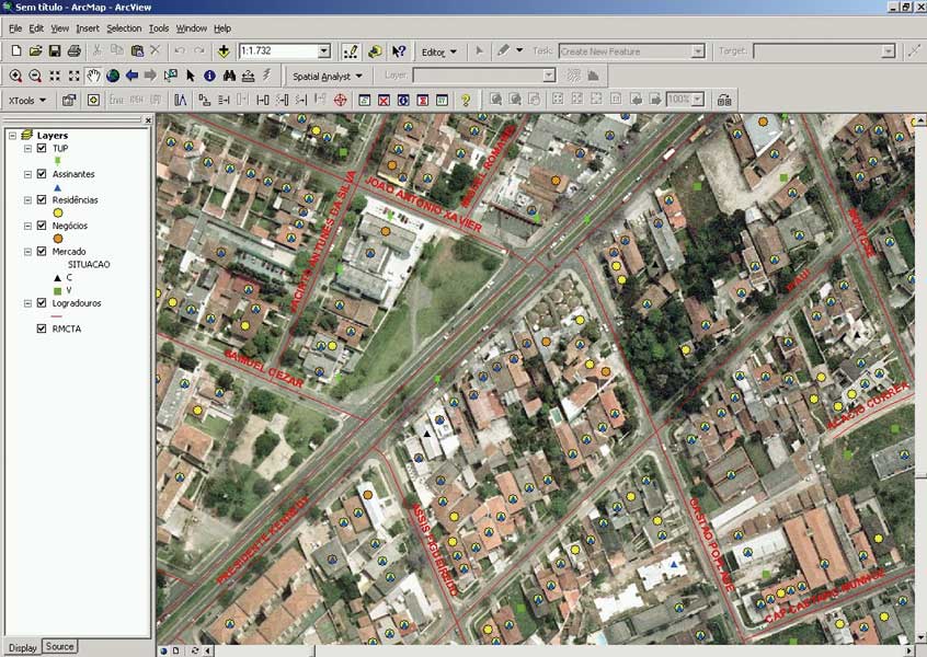
After using ArcGIS and the ArcGIS Geostatistical Analyst extension to examine the data and eliminate inconsistent and incomplete data, clusters of similar groups were generated using data containing approximately 130 socioeconomic variables. This type of analysis is commonly used for research such as digital interpretation of pattern recognition analysis. Distance measurements among groupings identified groups that were homogeneous with respect to certain criteria. For the project, 12 clusters were generated. These clusters are similar with regard to factors such as investment potential, infrastructure development, or cultural levels. Combining geographic information with statistical analyses provides higher quality and more precise results. Intraurban analyses used data geographically that was organized by census tract, street centerlines, and field surveys. Residential properties were classified using various specific criteria. Studies were carried out for market segmentation and qualification for residential and commercial markets. The data contained socioeconomic characteristics that allowed mapping of vacant parcels and buildings under construction and helped identify emerging markets and growth opportunities for Brasil Telecom. Revealing InformationBy geocoding customers and overlaying street network and aerial photos of market areas, it was possible to create evaluation algorithms that revealed information about current and potential clients that can identify where the network can be expanded or updated. Combining additional characteristics derived from fieldwork, such as socioeconomic class, products used, revenue levels, traffic types, and financial history, revealed marketing opportunities. These analyses showed average levels of consumption for the areas and showed where new products could be sold. Geostatistical AnalysesIn the near future, geostatistical analyses developed using GIS, coupled with other technologies for information dissemination, will improve the study of the fundamental nature of the telecommunications market. Better market knowledge and more accurate market segmentation will help the company find new clients, discover and grow new markets, and develop new products for targeted audiences. It will give Brasil Telecom the ability to view the market in a global way while still being able to focus on the local market structure.
The robust statistical analyses available through the use of the SAS Bridge extension with ArcSDE will supply analysis tools not previously available. Statistical studies, which were calculated and displayed in spreadsheets and displayed in graphs, will be enhanced with variables from other databases, modeled, and mapped for more powerful analysis. This capability is essential for studying the dynamic telecommunications market. ConclusionBeing able to see how market areas, clients, and competitors relate spatially will make the company more responsive to marketplace challenges. GIS helps realistically model conditions by mapping influential areas, the market penetration of proposed plans, and other scenarios to reveal market dynamics. These techniques will assist with planning tasks and feasibility studies for projects by supplying more precise cost estimates that optimize financial investments. Using GIS tools, Brasil Telecom has acquired knowledge of its service area and customers that is enhancing its network planning and creating investment opportunities in new technologies, which will generate more attractive products that will attract and hold customers. The project has helped develop applications for measuring sales channels and identifying existing services that can be commercialized without additional investment or high costs. For more information, contact George Serra Almeida About the AuthorsMaria da Concei��o Pereira has a major in business management and a master's degree in demography from the Universidade Federal de Minas Gerais. She is the manager for market intelligence at Brasil Telecom-BrT. George Serra Almeida is a geographer, specialized in GIS and computer science, and has a master's degree in GIS from the Universidade de Sao Paulo. He is the manager for the geomarketing and software localization sectors at Imagem Geosistemas E Com�rcio Ltda. Adriano Junqueira is an electrical engineer, specialized in accounting and project management. He is responsible for business development at Imagem Geosistemas E Com�rcio Ltda. |