October - December 2004
October - December 2004 |
||||||||
|
|
||||||||
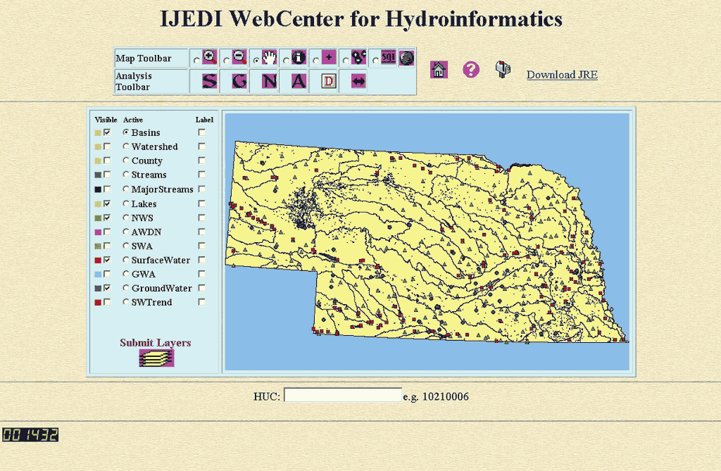
For hydrological data, stream flow, groundwater level, and precipitation measurements are representative data sources for each water basin. The hydrological information for surface water and groundwater is obtained from the USGS Water Resources of the United States Web site. The USGS National Elevation Dataset was used for topographic data and translations into shaded relief, aspect, slope, and terrain parameters for 8-digit HUCs. Data came from the SW, GW, NWS, and High Plains Regional Climate Center's Automated Weather Data Network (AWDN) stations. However, only stations that had more than 30 years of continuous data were used in this study. For precipitation, all 274 NWS and 46 AWDN stations in Nebraska were used. For the stream flow and groundwater level, only 124 of 274 SW and 74 of 166 GW stations were used. ArcIMS-Based DesignTo analyze, visualize, and disseminate the results of the IJEDI project, the authors built the IJEDI WebCenter for Hydroinformatics (water.unl.edu). At this site, users can create customized maps as well as seasonal and long-term trend analyses. Specific implementation steps included using
To use MapObjects to generate and display maps on the Web required a Web server program. Microsoft Internet Information Services was used. Given the amount of data and security issues, the client-requested strategy was adopted. The client inputs a request, indicates a map function, and manipulates a map on the Web page. ArcIMS processes the client requests and passes them to the VB/MapObjects program running on the server. Subsequently, the VB/MapObjects program parses each request and invokes a function that generates a bitmap. The WebLink control embedded in the VB/MapObjects program converts the bitmap to a JPEG file, which is displayed on an HTML Web page. This implementation strategy runs faster because it does not require the program to be loaded and unloaded from the server memory for each request. Incorporating the WebLink into the VB/MapObjects program was key to the use of MapObjects IMS in the design and implementing online communication and data handling features. The IJEDI WebCenter for Hydroinformatics currently has 12 digital coverages-basins (8-digit HUCs) and watersheds (4-digit HUCs). It also has TIGER 1:100,000-scale county boundaries, major streams, and streams; NWS and AWDN data; USGS stream gauge data; and USGS groundwater monitoring well data. The site is not a pure GIS-based application. It combines GIS tools, the Internet, and object-oriented programming. TheWebCenter includes a Map Toolbar that provides basic functions such as zoom in, zoom out, and pan and feature identification (e.g., a surface water station). The Analysis Toolbar provides customized graphs for user requests and allows for compare-and-contrast visual analyses. The Identify function retrieves information (e.g., name, location, chart) for a specific region or item on the map. Special FunctionalityThe Add Sites function acts as a multisite selector. When the active layer is a point feature layer, such as stream gauges, the user can use this function to successively select points on the active layer and request a graph that combines the measurements of these sites or stations. The Analysis Toolbar is used primarily for visualizing SW, GW, NWS, and AWDN datasets using graphing routines. Online, real-time graph charting functions can be invoked for visualizing a single station's data, data for multiple stations, or all the data for a water basin. Additional functionality, such as text-based queries, clustering driven search, station-based similarity queries, and stream gauge animation, is being developed. SummaryUnderstanding hydrological processes in a geographic area is a difficult task. Information related to these processes is stored in a variety of datasets that measure different aspects. Surface water, groundwater, aboveground climate, and geomorphology all provide a component view of the overall hydrological cycle that characterizes a region. Integration of information from these diverse, but related, sources is an essential step in understanding the hydrological processes. This GIS-based tool can be used to analyze and visualize information from a variety of hydrological datasets. The IJEDI WebCenter for Hydroinformatics provides users with analysis based on individual stations or at the water basin level. Currently, it provides graphing and visualization tools that make the identification of trend and patterns in a landscape easier. By designing new analysis tools, this project will assist in decision support through the use of hydrological information. For more information, contact Jing Zhang, e-mail: jzhang@cse.unl.edu Acknowledgment: This work is sponsored by a National Science Foundation Information Technology Research grant (ITRF#IIS-0219970). The authors would like to thank the United States Geological Survey, United States Department of Agriculture, High Plains Regional Climate Center, and National Drought Mitigation Center for support in domain knowledge and expertise. The authors would also like to thank Marcus Tooze and Andy Rutledge at GIS Workshop, Inc., for their support. References—In PrintHeim, Richard R. Jr., "A Review of Twentieth-Century Drought Indices," U.S. Bulletin of the American Meteorological Society, Vol. 83: pp.1149-1165, August 2002. Ralston, B.A., Developing GIS Solutions with MapObjects and Visual Basic, Onword Press, 326 pp., 2001. Seaber, P.R., F.P. Kapinos, and G.L. Knapp (1987). "Hydrologic Unit Maps," U.S. Geological Survey, Water-Supply Paper 2294, 63 pp., 1987. United States Department of Agriculture, Soil Conservation Service, State Soil Geographic Database (STATSGO) User's Guide, Miscellaneous Publication No. 1492, National Soil Survey Center, Lincoln, Nebraska, 1994. USGS EROS, National Elevation Dataset Fact Sheet 148-99, Earth Resources Observation Systems Data Center, Sioux Falls, South Dakota, 1999. References—OnlineUnited States Census Bureau TIGER, TIGER/Line, and TIGER-related products United States Department of Agriculture, National Agricultural Statistics Service, National Research and Development Division, Cropland Data Layer for Nebraska Web page |