Safeguarding Coastal Wetlands Through Exotic Species Control
 |
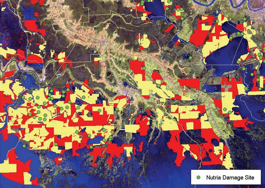
| The Louisiana Department of Wildlife and Fisheries needs to identify areas of known nutria damage with little or no hunting activity. The yellow polygons are harvested areas, and the red polygons are leases with no hunting activity. |
There are critters gnawing away at Louisiana's already disappearing coastal wetlands. Native to South America, a nutria look like a cross between a beaver and a rat and can consume 25 percent of its weight in aquatic plants each day.
Nutria were originally valued for their pelts. From the early 1960s through the mid-1980s, more than one million nutria were harvested annually, mostly for the European fur industry. With the collapse of the fur market, there is currently no significant demand for nutria. This has allowed the population to grow unchecked. Now considered a nuisance species, approximately 80,000 acres of coastal wetlands are impacted by nutria at any given time according to Louisiana Department of Wildlife and Fisheries (LDWF) estimates.
Over the past 50 years, Louisiana has lost land at an average rate of 34 square miles per year. This loss is due to natural processes that include shoreline erosion, subsidence, saltwater intrusion, and faulting as well as human activities such as levee construction. Because nutria tend to overgraze an area, they not only remove surface plants but they also often destroy plant roots and expose fragile organic soils to erosion. Damaged areas may deteriorate and become open water, which exacerbates the land loss problem.
The Coastal Wetlands Planning, Protection, and Restoration Act (CWPPRA) provides funding for many coastal restoration activities including the Louisiana Coastwide Nutria Control Program. The primary objective of the program is to significantly reduce marsh damage from nutria by removing 400,000 nutria per year. This is accomplished by paying registered trappers and hunters an incentive payment of $4.00 for each animal harvested. In 2002, the $13 million multiyear program was approved and the first nutria hunting season ran from November 20, 2002, to March 31, 2003.
LDWF is responsible for overall program management using funding obtained from the Louisiana Department of Natural Resources and the Natural Resources Conservation Service. Coastal Environments, Inc. (CEI), an Esri business partner in Louisiana, was chosen to administer the program. CEI manages the nutria harvest and pays participants. The company also developed and maintains the program database and a mapping system for analyzing participants' hunting activities and nutria damage assessments.
Over the past few years, LDWF has documented and mapped nutria damage areas along the coast by conducting aerial surveys of established transects using ArcView 3.2. (Transects are study boundaries along which samples are collected.) Identifying nutria harvest locations and determining if these areas are in or adjacent to documented damage areas are two of LDWF's primary requirements. To address these requirements and other reporting and mapping needs, a Microsoft SQL Server 2000 database was developed to maintain participant and landowner information and a geodatabase was implemented with ArcSDE 8.3 for maintaining the associated spatial data. ArcInfo 8.3 was used for all mapping activities, and a Microsoft Access front end was developed for easy field data entry.
 |
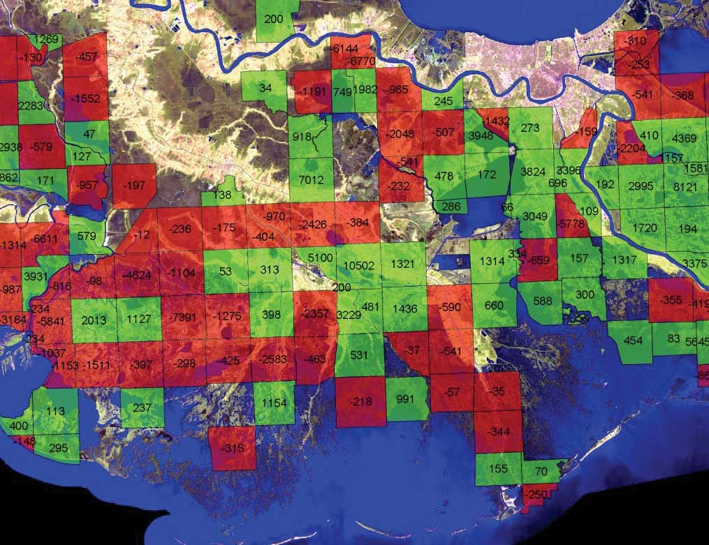
| Harvest data can be summarized by township and range so harvests for different seasons can be compared. This example displays the changes in harvest distribution between the first and second seasons. Red indicates a decrease, and green indicates an increase in harvest activity for the second season. |
As part of the application process, potential program participants must include maps and legal descriptions of their hunting leases. A participant may have multiple leases, and a landowner may have multiple participants hunting on the same lease. Once an applicant has been approved by LDWF, participant information is entered into the SQL database and the related leases are incorporated into the nutria geodatabase Lease feature class. For the 2003–2004 season, 428 leases covering 1,820,105 acres were mapped.
The area of a lease may vary dramatically from less than 100 acres to thousands of acres. Consequently, mapping a participant's nutria harvest at the lease level is not sufficiently detailed. The initial contract required mapping and tracking of nutria harvest by township and range. However, a finer level of detail-the actual area hunted by each participant on each lease by township and range-was needed.
A custom script that programmatically created individual lease maps by participant was developed. More than 500 maps were produced for the 2003–2004 season and were used at the nutria collection stations where participants turned in harvests. Using a field laptop with a copy of the database, the collection manager entered the harvest total for each participant. The lease, township and range, and methods of harvest and carcass disposal were also entered. Each participant is required to identify harvest locations on lease maps. Because a participant may turn in multiple harvests throughout a season, this process was repeated every time a participant submitted a harvest.
The field database and lease maps were returned to CEI's main office each week. The field database was uploaded to the program database, and the areas hunted were digitized from the hard-copy lease maps and added to the Take feature class in the nutria geodatabase. The Take feature class documents the transaction number, participant, lease, program week, township and range, and harvest amount. The field laptop was returned to the collection manager with any updates from the program database. Harvest maps were produced by both week and month and delivered to LDWF so the department could track the hunting activities of program participants. During the 2003-2004 season, 1,039 harvest areas, covering 780,948 acres, were mapped.
LDWF also used Esri software during annual aerial transect surveys. When vegetation damage was identified, the location was captured using differential GPS. An ArcView 3.2 extension, GPS View, was used with ArcView 3.2 on a laptop. Each damage site was recorded by logging polygons using stream mode digitizing with GPS equipment. The damaged sites were then analyzed in relation to the season's hunted areas.
Adopting the geodatabase has benefited the program's mapping activities. CEI did not use ArcSDE or the geodatabase model during the first season. Migrating to ArcSDE during the second season made integrating the program database easy and simplified the reporting process. With its topology, relationship classes, and more robust editing tools, the geodatabase model has proved more efficient than using coverages and shapefiles. Improvements in mapping and data development continue to be made each year. Plans for next season include improvements to the geodatabase structure, additional topology rules, and new scripts for improving mapping efficiency.
LDWF estimates that it will take three to four seasons of sustained harvesting to noticeably reduce nutria damage. Findings from the 2002–2003 season show an increase in the number of damaged areas that are recovering and fewer areas that have converted to open water. During the first season 308,687 nutria were removed. Program participants in the 2003-2004 season removed 332,596 nutria. However, aerial survey results for this season were not complete when this article was written. For more information, visit www.nutria.com or contact
Lori Burns Cunningham, GIS Manager
E-mail: lcunningham@coastalenv.com
or
Steven Ward, GIS Analyst
E-mail: sward@coastalenv.com
at
Coastal Environments, Inc.
Tel.: 225-383-7455
or
Jeff Marx, Biologist
Louisiana Department of Wildlife & Fisheries
Tel.: 337-373-0032
E-mail: marx_jm@wlf.state.la.us
|