October - December 2007
October - December 2007 |
||||||||
|
|
||||||||
The Malay peninsula has been on the international map for centuries owing to its strategic location between Eastern and Western civilizations. Several centuries ago when rivers were the major means of transportation, at least five transpeninsular trading routes connected large port cities on the eastern and western coasts of the peninsula. One route was very important for Malacca, a major sultanate entrep�t [i.e., market center] during the 15th�16th centuries.
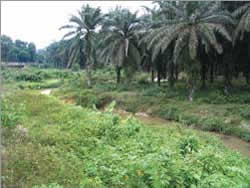
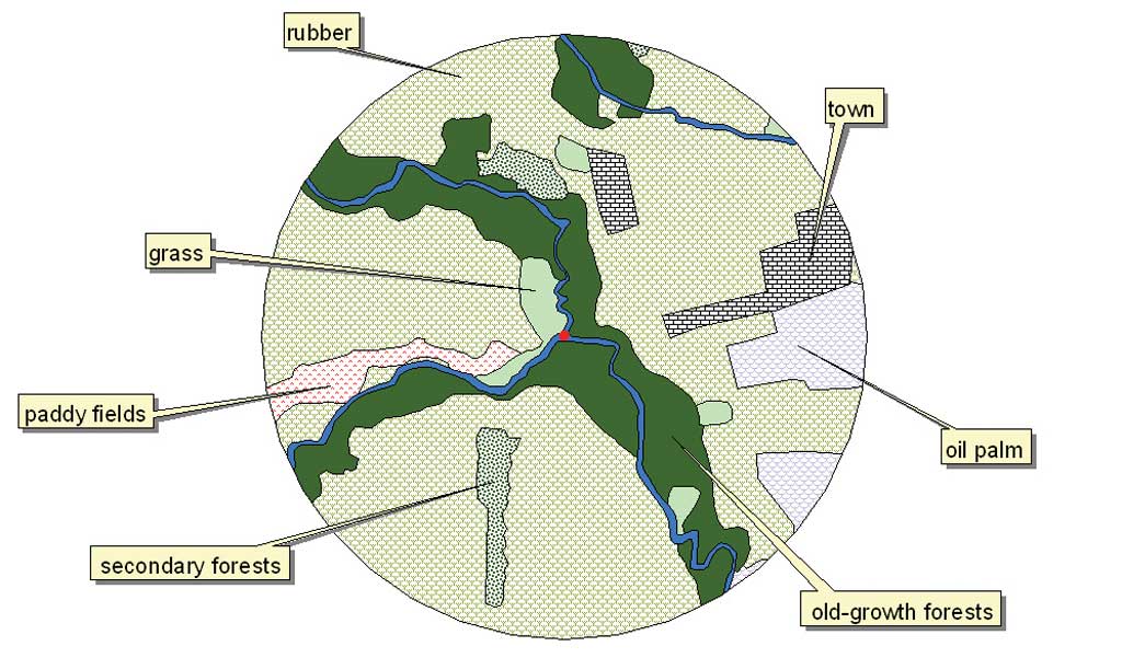
As evidenced by early maps, western cartographers and travelers imagined it was a transpeninsular river. In 1613, Malay-Portuguese author and cartographer Manuel Godinho de Er�dia depicted it, not a transpeninsular river but two rivers near each other and connected by a land portage. His map was based on information he obtained from local people. The land portage had various names, but the one that survives is Penarikan. In its heyday, Penarikan was a small town ruled by a chieftain, and the surrounding riverine areas were thriving paddy field villages. Despite its important heritage value, studies on the vicissitudes of land use in the Penarikan site are lacking. Since the last written record made in 1875 by D. D. Daly and noted by A. M. Skinner in "Geography of the Malay Peninsula" published by the Journal of Straits Branch of the Royal Asiatic Society, almost nothing about the land portage exists in the literature despite the resurgence of national interest in protecting and conserving the natural and cultural heritage of Malaysia. To fill the gap in the historical data, the authors conducted a GIS-based study in 2007 to track the land-use changes in Penarikan. This analysis also permits an understanding of the impacts of landscape transformations on rivers and land. There is a positive correlation between the rates of certain human activities and pressures on these natural resources.
In the study, topographical maps of comparable scales were used as basemaps. These maps represented two different decades, 1960s and 1980s, subsequent to Malaysia's independence from Britain in 1957. Data capture, spatial analysis, and map representations were conducted in ArcView. Spatial analysis showed that in the decades following Malaysia's independence, the Penarikan site underwent physical changes that had socioeconomic ramifications. It can easily be supposed that land-use pressures continued to increase when, by the mid-1980s, urbanization was taking place at the study's site. In the mid-1960s, rubber plantations were the dominant land-use type. This remained so until the mid-1980s. The country was highly dependent on rubber as the foreign exchange earner during this time. Traditional paddy fields decreased by two-thirds between the mid-1960s and the mid-1980s. This is consistent with Malaysia's demographic changes generally during a period that was characterized by massive migrations of young people to the cities and villagers joining government-sponsored resettlement schemes to earn a living from tapping rubber. What could be the immediate effects of these changes to the landscape? There is concern about water quality because effluent from households and shops flows directly into the rivers as well as about river siltation due to vegetation clearing in the watershed area. At the same time, rapid land development due to the expansion of town areas and the widening of main roads leaves little or no room for heritage protection.
Given the complexities of land use at this site, there is clearly a need to create a conservation agenda or heritage visitor center to highlight the historical significance of the site. For a start, the local authority should provide footpath access so the public can experience and appreciate the historic value of the Penarikan. The authors plan to expand this GIS-based project to design a trail that will connect places of historical significance in the area and make information on the site available to the public via the Internet. For more information, contact Nor Rasidah Hashim at rasidah@env.upm.edu.my. ReferencesWheatley, Paul. 1973. The Golden Khersonese: Studies in the Historical Geography of the Malay Peninsula Before A.D. 1500. Kuala Lumpur: University Malaya Press. Mills, J. V. 1997. Eredia's Description of Malacca, Meridional India, and Cathay. (Translated from the Portuguese with notes). Kuala Lumpur: Malaysian Branch of the Royal Asiatic Society.
Hashim, N. R. 2006. "Anthropogenic Tropical Forests in the 21st Century: The Creation, Characteristics and Uses of Secondary Forests in Negeri Sembilan, Peninsular Malaysia." Ph.D. Dissertation. Department of Geography, University of Cambridge, United Kingdom. Skinner, A. M. 1878. "Geography of the Malay Peninsula." Journal of the Straits Branch of the Royal Asiatic Society. No. 1: 52�62. About the AuthorsNor Rasidah Hashim, Ph.D., is a lecturer on the faculty of the Environmental Studies Department at the Universiti Putra Malaysia. Her research interests include forest ecology and heritage conservation. She is a native of the Penarikan area. Naziaty Mohd Yaacob is a senior lecturer on the faculty of Built Environment in the Department of Architecture at the University Malaya. Her Ph.D. research project is on the accessibility of historic buildings. |