October - December 2007
October - December 2007 |
||||||||
|
|
||||||||
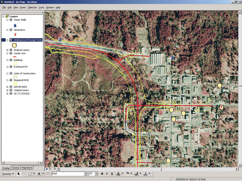
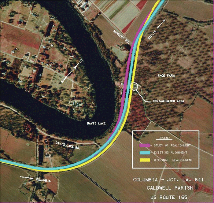
Louisiana's Transportation Infrastructure Model for Economic Development (TIMED) program is the largest transportation program in Louisiana history. The plans include widening 536 miles of state highways and three large bridges in addition to new construction on those bridges. Budgeted at more than $4.7 billion, the ultimate goal of TIMED is to enhance economic development in the state with an improved transportation system. LaDOTD selected LTM to minimize the duration of this project, which began with legislation in 1989 and has an anticipated completion date of 2031. The Baton Rouge, Louisiana-based LTM is a joint venture of PB Americas, Inc. (PB), THE LPA GROUP INCORPORATED (LPA), and GEC, with each firm bringing expert knowledge and years of experience in planning, design, engineering, and program and construction management needed for a program of this magnitude. EV: How long has GIS been a part of the TIMED project? JD: Since before the project began. We utilized some readily available data to help cost and schedule the project. EV: Which Esri products are you using? JD: We are using ArcGIS Desktop software, ArcIMS, ArcPad, and ArcExplorer. [At 9.2, ArcIMS functionality is now found in ArcGIS Server.] EV: How is GIS being applied? JD: There are three key areas. A GIS-based intranet site allows our environmental engineers to readily access geospatial information without a lot of training in GIS. They can easily pull up the site when the phone rings with a DOTD executive or a landowner on the other end. Other key areas include our field biologists using ArcPad for GPS data collection in GIS format, which ultimately allows us to accurately analyze environmental impacts, and using GIS to prepare the necessary figures and plates for reports. From a decision-making standpoint, another example would be an alignment that was changed as a result of developing a GIS dataset. The proposed alignment of the new highway would have impacted some underground storage tanks. We were able to work with our transportation design engineers to propose a new alignment with fewer environmental impacts. EV: Are you incorporating legacy systems such as document management or financial systems? JD: Yes. The end product of this work is a report—well, many reports. Some project segments can have as many as 15 different reports for the various federal and state agencies. This is maintained in a system at the LTM main office in Baton Rouge and is Internet based. We were able to incorporate hyperlinks on the Web site for these reports as they apply to each segment. This created a more centralized dataset for our engineers and for LaDOTD. EV: How do you work with CAD data within the GIS? JD: The required right-of-way was the foundation for all impact assessments. This data layer came directly from CAD data. These CAD datasets were first stripped of any ancillary information that we didn't need such as labels, arrows, and leaders. Then we put that data into the GIS for georeferencing, polygon building, and attribution. The attributes included the appropriate highway segment number and right-of-way description: existing or required. EV: What challenges did you face along the way? JD: Obtaining the CAD data was number one. Standardizing the CAD data and determining where one project would end and another would begin are some others. EV: How did you handle them? Do you have any advice for people facing the same kinds of hurdles? JD: To gather the data, we obtained a list of all highway segments included in the TIMED Program and researched who was responsible for the design work. We then had to contact each one and request the necessary information in CAD format. Some of these highways were constructed in the 1930s. Needless to say, sometimes this was impossible because the data simply did not exist. For these segments, we were forced to use paper as-built plans from a vast library at LaDOTD, input that information into the GIS, and georeference it. We field checked our information with GPS points at specific locations. This is not ideal, but it was the best data we had to work with. Our GIS technicians quickly began a good working relationship with our drafters and engineers to educate us on how to accurately read the plans. The information we gathered will be turned over to them when the project is complete as part of that library.
Another major challenge was the format the CAD data would arrive in. Our GIS technicians were familiar with commonly used CAD-based software packages such as AutoCAD and MicroStation, which helped tremendously. We would standardize and clean up the data in its native software as much as possible, georeference it in ArcGIS, then convert it to shapefiles. Advice here would be for state transportation departments to set standards for plan and design submittals. We provided recommendations to LaDOTD engineers for CAD data criteria to incorporate in future scopes of work for contractors. An example of this is to keep required rights-of-way on a separate layer from construction limits. This eases interoperability between GIS and CAD data. These recommendations were part of a larger lessons-learned meeting between LTM and LaDOTD to share thoughts and ideas. We in the GIS Department assumed we were asking a simple question, "Where does one project end and one begin?" When the data from segment to segment began coming into the GIS, we made a basic assessment. There is overlap at the ends of these projects and sometimes significantly. We had to develop a system that incorporated the construction limits and the construction schedule. If a segment was scheduled for construction sooner than another, it took precedence. This was important for the environmental reports; they were written and submitted by project segment. Having a beginning and an end helped, to say the least. When the plans existed in book format for each segment, it was difficult to assess this overlap. EV: How do you work with the other members of LTM and the LaDOTD? JD: GIS provided a common operating platform for data collection, analysis, evaluation, reporting, and communication. LTM staff members across the state were trained to use the Web application. LaDOTD GIS staff was consulted before implementation to ease the transfer to them at the end of the project. There were some datasets that we could not distribute on the Web due to homeland security issues. In that case, we utilized ArcExplorer for an individual, desktop application. Hands-on training was provided as necessary. EV: So you were able to use GIS tools to facilitate environmental documentation and permit applications? JD: Yes. GIS was the primary tool for this process. We analyzed field data for impacts and prepared figures for the permit applications. The figures were also exported into image formats for the electronic versions of the reports. EV: How did that help improve communication statewide? How were you sharing that data before? JD: This leveled the playing field for communication. Departments such as real estate, design, environmental, and other regulatory agencies all had the latest and greatest information at their fingertips. Prior to this implementation, data was not being shared. EV: What is the status of the TIMED Program now? JD: Of the 125 project segments on the TIMED Program, 22 are in the preconstruction phase, 37 are in the construction phase, and 66 are complete as of last quarter. Hurricanes Katrina and Rita and increased global demand for critical transportation infrastructure resources have had an impact on the TIMED program. The challenges faced in completing the program on time and on budget have increased in complexity, and the magnitude of the impacts is becoming more clear as additional project segments are set. Despite these impacts, the TIMED Program is moving forward and assisting in the recovery of Louisiana's infrastructure. It is still on an accelerated schedule for completion and is investing Louisiana dollars back into the economy. The program also maintains an 80 percent residency requirement on all contracts, ensuring it provides in-state jobs for workers. Ultimately, TIMED is building critical evacuation routes, investing in transportation, and providing economic growth throughout the state. Jerri Daniels
Jerri Daniels is a project manager at GEC who has been with the company for seven years. She specializes in developing ArcInfo applications for a variety of projects. Most of these applications involve creating GIS data from various sources, including field data collected with GPS, and applications for environmental impact projects especially related to analysis of drainage basins and watersheds. She is also a certified GIS professional and a certified floodplain manager. She received a master's degree in geography from the University of Alabama, Tuscaloosa, Alabama, and a bachelor's degree in environmental science from Auburn University, Montgomery, Alabama. She is also the proud mother of a three-year-old daughter, Marina. For more information on the TIMED Program, contact Jerri Daniels at jdaniels@gecinc.com. |