by Mike Price, Esri Mining Industry Solutions Manager

|
Finding Data for 3D Terrain Modeling by Mike Price, Esri Mining Industry Solutions Manager |
|
STEP 1: 2D model of west end of Grand Canyon National Park, showing contours, hydrology, trails, boundaries, and geographic structures.
Step 2: 2D shaded TIN created from 50-meter contour lines.
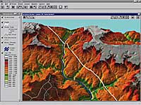
 Step 3: 3D perspective view, west end of Grand Canyon National Park, displayed in an ArcView 3D Analyst view. |
ArcView 3D Analyst provides desktop GIS users with the tools to create high-quality digital terrain models (DTMs). Modeling data are available in several forms at no charge on the Internet. The U.S. Geological Survey (USGS) maintains Web sites that provide free downloadable modeling data via FTP protocol. The URL for a preferred site, maintained by the USGS Earth Resources Observation Systems (EROS) group, is http://edcwww.cr.usgs.gov/doc/edchome/ndcdb/ndcdb.html. Terrain data are available without charge as digital elevation models (DEMs) and digital line graphs (DLGs) to anyone who is confident and patient enough to download these files. DEMs in standard USGS format may be loaded directly into ArcView 3D Analyst or ArcView Spatial Analyst. DEMs provide gridded elevation data at various levels of resolution. They may be used as a base for detailed terrain modeling, hydrologic modeling, or other tasks. DLGs include sets of vector data mapped at several scales. Separate sets contain spatial information including hypsography (contour lines), hydrography (lakes, rivers, streams), and Public Lands Survey System (section lines). DLG data sets can also contain transportation data including roads, railroads, and land boundaries. DLG files provide an excellent data set for three-dimensional terrain modeling with ArcView 3D Analyst. Hypsography is readily converted into triangulated irregular networks (TINs). Line and polygon DLG data, such as lakes, rivers, and roads, can be draped onto the TIN. User-generated data in UTM projection may be added to the model. The modeling procedure is somewhat complicated, but it is also very structured and systematic. Several conversion methods are available to take data from DLG format to ArcView GIS. Esri staff and industry users are now documenting the best procedures to download, convert, load, and model DLG data from the USGS site. In March 1998, Mike Price, Mining industry Solutions Manager for Esri, Bill Price of Black Rock Resource Company, and Charles E. Cook of CBS Consultants presented a technical paper describing the procedure at the 1998 annual meeting of the Society of Mining, Metallurgy, and Exploration (SME). The paper will be available on Esri's mining Web site. Please visit Esri's mining Web site at www.esri.com/mining to download a copy of this paper that describes in detail the entire procedure. Here is a brief description of DLG data acquisition, conversion, and modeling. DLG files are created in a UTM projection using the NAD 27 datum and the Clarke 1866 ellipsoid. Horizontal and vertical units of measure are metric. Data are available at several scales and formats. Consistent, reasonably current data are available throughout the United States at a 1:100,000 scale in an optional format. A newer Spatial Data Transfer Standard (SDTS) format is also available at some scales. The United States is mapped at 1:100,000 scale as a series of 1-degree by 30-minute map sheets. For download, each sheet is divided into eight 15-minute by 15-minute tiles. Each tile includes five to seven related files containing the vector data listed above. DLG data are downloaded in a zipped GZ format and must be extracted by the user. Individual file names are long and confusing. Data files are best renamed as they are downloaded and unzipped. The SME paper available at the Esri Web site will explain file downloading, extraction, and preferred file naming conventions. File management is very important while downloading data. The most difficult part of the entire 3D modeling process is downloading the DLG data from the Web, which requires time, patience, and organization. Converting data from DLG for use with ArcView GIS presents other issues. Translating data to an intermediate AutoCAD DXF format appears to be the most stable, intuitive procedure. A third party DOS utility performs the DLG/DXF conversion. Tests are currently underway to determine which switches work best with ArcView GIS. The conversion can be performed interactively or in DOS batch mode. The CAD Reader for ArcView GIS will read the intermediate DXF directly including available elevation. Once loaded into ArcView GIS, contour lines are readily converted to an ArcView GIS shapefile, which can then be edited and built into a TIN with ArcView 3D Analyst. Other data may now be draped onto the TIN surface to enhance the 3D model. It is not necessary to convert draped DXF data into shapefiles except to edit or enhance the data. ArcView GIS legends built around the layer value field provide many thematic display options. Within each DLG/DXF data set, the CAD layer is coded to provide additional information about data types. Price is developing methods to standardize the layer coding and to convert it to a mapping vocabulary. Upcoming issues of ArcUser will feature articles exploring other aspects of data modeling using ArcView 3D Analyst and show how you can use Data Hound to find the best sources for modeling data and GIS conversion utilities. Text of the SME presentation will soon be available on Esri's mining Web page. If you are feeling brave and adventurous, download a copy of the detailed conversion paper from the Esri mining Web site. Next, visit the EROS data site named above, explore the available data, and download some data from your part of the world. Finally, convert and load the data into ArcView GIS and ArcView 3D Analyst and begin to explore in 3D modeling using data from your own backyard. |