|
Summit Held to Set Course for This New Field That Couples GIS and Design
Designing GeoDesign
By Carla Wheeler, ArcWatch Editor
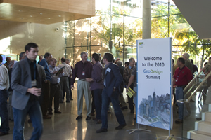 The 2010 GeoDesign Summit drew more than 170 academics and professionals from many fields, including architecture, urban planning, conservation, geography, and GIS. Photo by Eric Laycock/Esri |
The word GeoDesign and its definition may be newly coined and evolving, as this Wikipedia entry attests. But at the world's first GeoDesign Summit last January, Esri president Jack Dangermond said the concept of incorporating geographic knowledge into design has been happening for a very long time.
"GeoDesign is going on. It has been going on for hundreds of years," he said, pointing to examples in farming, urban planning, and site selection for stores. Farmers, for example, have always taken geography into account when deciding what crops would be appropriate to grow on their land and where to locate their farms (e.g., near a water source for irrigation).
Because of pressing planetary problems that need to be solved, Dangermond and a group of thought leaders from academia and a variety of professions believe it's time to better integrate geospatial technologies such as GIS with design. During the summit, they also discussed future GeoDesign education and training options and how to provide designers with the tools they need to better create and analyze designs.
"We are at the beginning of what many of us see as a new field," said Thomas Fisher, dean of the College of Design at the University of Minnesota, in his keynote address.
With the world facing what he called "exponentially increasing stress on the systems we depend on" such as natural ecosystems and building infrastructure, a great need exists to use spatial data and technologies in planning and design to tackle problems such as those associated with global warming, threats to species, and poorly designed infrastructure.
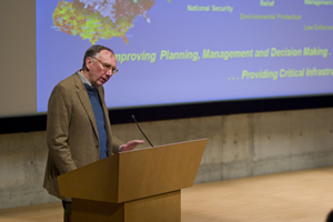 Esri president Jack Dangermond stressed the importance of integrating design with geospatial technologies. Photo by Eric Laycock/Esri |
"One of the powers of GeoDesign is it makes these problems visual," he said. "They are easier to ignore when they are abstractions. Because we have been designing the world without data-rich knowledge of consequences, we've created a situation where we've made ourselves vulnerable as a species, which to me gives urgency to GeoDesign. This is something we don't have a lot of time to develop."
The purpose of the two and a half-day summit was to
- Define and formalize the term GeoDesign and its methodology.
- Promote and advance GeoDesign research and education.
- Discuss how to go about creating better GeoDesign technologies/tools.
- Talk about how to more deeply couple design with GIS and other geospatial technologies.
- Prepare a set of use cases to show what GeoDesign can accomplish.
To jump-start the process, the University of California, Santa Barbara; the University of Redlands; and Esri sponsored the inaugural 2010 GeoDesign Summit at Esri's corporate headquarters in Redlands, California. More than 170 academics and professionals attended from fields such as geography, architecture, GIS, urban planning, engineering, conservation, and forestry. Besides listening to keynotes and lightning talks on GeoDesign and how it's being used, they also attended "idea labs" to create agendas for GeoDesign theories, education, future technologies, 3D visualization, and analysis in design and other topics.
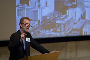 Thomas Fisher, dean of the College of Design at the University of Minnesota, believes that designing using rich data and technology will have a positive impact on the planet. Photo by Eric Laycock/Esri |
In his opening remarks, Dangermond spoke about the great potential for GeoDesign, described by some as a pairing of design and GIS. It unites the art and creativity of design with the power and science of geospatial technology. As one, GeoDesign can produce more informed, data-based design options and decisions.
"The notion of integrating these two fields is very exciting to me. We have a kind of continuum from measurement to making decisions that integrates all of our ways of doing things into new processes," Dangermond told the gathering.
Dangermond said fast accelerating improvements in geospatial technologies will, consequently, hasten advances in GeoDesign. New design-friendly capabilities and tools in the upcoming release of Esri's ArcGIS 10 will help professionals apply GeoDesign methodologies to problems and challenges related to anything from climate change to pandemic diseases, environmental protection to food production, and resource conservation to infrastructure improvements.
"Geospatial technology is migrating to the Web and will be used by practically everyone in some way or other," Dangermond said. "This environment is a new style for how geography will be served and how it will affect us. It will touch not simply a few researchers, GIS professionals, or those who work with geographic information, but it's infecting and affecting virtually everything that people do." Improvements in GIS, the explosion of location-based services (LBS), faster computers, more bandwidth and storage, a boom in mobile devices, and the emergence of cloud computing will also speed GeoDesign along, according to Dangermond.
 The 2D geodesign tools available with ArcGIS 10. |
"For some of us, that's all brand new," Dangermond said. "Some people describe this as 'disruptive' kinds of technology. For me, it's just another step in the evolution in the enabling technology that allows us to bring these new ideas that will come out of this meeting to fruition.
"Organizations also are beginning to serve geographic knowledge, which is providing a new infrastructure to build on top of, hopefully, the design notions that come out of the summit," Dangermond continued. "Agencies will not be providing data files or maps. They will be providing services, and these services will be a new framework," he said. "Just like the Apple iPhone is providing a framework for all kinds of apps, these geospatial services—and the ability to build creative applications on top of them—will explode our field and the general interest in designing our future."
Designer-Friendly GIS Technology
Matthew Baker, Nathan Shephard, and Bern Szukalski from Esri demonstrated to the group current tools and services and soon-to-be released technology that will assist designers in their work. Baker's demonstration focused on the modeling, sketching, and feedback capabilities in Esri's ArcGIS Desktop 10, set for release in the second quarter of 2010. To find the best areas suitable for redevelopment in Detroit, Michigan, he created a model that used public GIS data and extracted block group parcels in the city that met criteria such as high poverty rates, vacant properties, and high unemployment.
"The results of the model pointed me to key redevelopment areas," Baker said. He used basemaps available from ArcGIS Online, an Esri Web site that provides free maps and other resources for GIS applications.
Baker then began sketching a new neighborhood using standard land-use symbols for neighborhood design, which will be available in feature templates in the ArcGIS 10 editing tools. He received instant feedback in the form of pie and bar charts on the suitability of his designs, based on the features sketched using an ArcGIS 10 add-in called the Dynamic Charting tool. Every time new features are added to the map, the Dynamic Charting tool provides additional updates.
Shephard demonstrated new design-friendly capabilities in the 3D Analyst extension of ArcGIS Desktop 10 such as
- Template-based (sketch) editing in 3D.
- 3D vector analyses of line-of-sight, 3D object intersections, and skylines.
- Volumetric analysis of buildings, shadow impact, and visibility zones.
- A template of a virtual city, which provides a useful example of a well-defined 3D city. The four key elements of such a city include a topographic basemap, high-resolution imagery, an elevation surface, and 3D buildings. If the data is available, users can add other elements such as vegetation, streetlights, and furniture such as park benches.
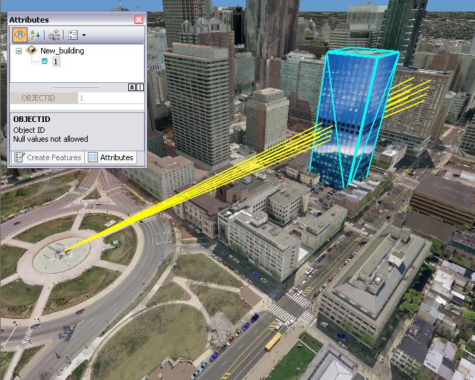 Using ArcGIS 3D Analyst, you can place proposed buildings directly into the GIS and run a 3D analysis such as a line-of-sight impact study. |
"These new capabilities allow you to quickly and accurately solve 3D GIS problems, such as assessing the impact of a proposed building on your city or identifying areas of concern based on 3D topography," said Shephard.
Szukalski showed the audience ArcGIS Online resources that, for GeoDesigners or Web Mappers, serve as what he calls an "excellent substrate" of content such as
- The World Topographic Map service, which includes boundaries, cities, water features, physiographic features, parks, landmarks, transportation, and buildings.
- The updated World Imagery map, which compiles the best available imagery for the United States and many cities around the world including London, England, and Geneva, Switzerland.
- Bing Maps for Enterprise, aerial, hybrid, and roads.
- The new World Street map, which includes building footprints for major cities. Contributions come from a variety of sources including Esri users.
"These new basemaps and others provide great maps you can use as is or to represent a great canvas for design or GIS work," said Szukalski.
Urgent Need for GeoDesign
 The new World Street Map service from ArcGIS Online provides highway-level data for the world and street-level data for North America, Europe, Southern Africa, and several Asian countries. |
The summit brought together thought leaders in GIS, architecture, design, conservation, and many other fields including Michael Goodchild, professor of geography at California State University, Santa Barbara; Carl Steinitz, research professor at the Graduate School of Design, Harvard University; Kim Tanzer, dean of the School of Architecture at the University of Virginia; and William B. Rogers, president and CEO of the Trust for Public Lands.
They spoke about how GIS is being used in design today and the even greater potential to integrate the creativity of design and the science of GIS.
Fisher from the University of Minnesota spoke passionately about how there's little time to waste. Citing ideas put forth by the Pulitzer Prize-winning author Thomas Friedman and professor of psychology David Barash at the University of Washington, Fisher argued that humans have created a giant Ponzi scheme with the planet over the last several hundred years, sucking resources and exploiting labor to maintain a certain way of life.
|
This leads to the creation of what Fisher described as "fracture-critical systems" like the one that led to the collapse of the Interstate 35W bridge in Minneapolis, Minnesota. Other fracture-critical threats include the exponentially increasing atmospheric carbon accumulation and rapidly declining biodiversity. "Even the recent financial crisis grew out of a fracture-critical system," Fisher said. "We designed financial products such that we increased the debt . . . where a few investment banks go down and they bring the entire global financial community down with [them]," Fisher said. "It's a classic collapse of a fracture-critical system. There is a spatial component to this. The banks do not know where the debt lies. Here, too, GeoDesign can help us understand the flows of money spatially across the planet.
Fisher called a fracture-critical system a metaphor for the world humans have designed for themselves. But he pointed out that innovations such as GeoDesign can help reverse the course.
"A lot of what we have been designing—our cities, our buildings, our landscapes—have been designed without a lot of information about the consequences of our actions on other species, on distant populations, on future generations," he said. "As GeoDesign can bring data to bear on those design decisions, it will profoundly change the way we live and inhabit the planet. Through innovation, we can rethink the way in which we inhabit the planet, we can rethink the way we use resources, and we can prolong our ability to sustain ourselves. GeoDesign's time has come, and it's none too soon." Dangermond concurred. "We need this right now," he said. "We need to not only understand what's occurring on the planet, but we also need to take more proactive involvement in designing what occurs. Then we have to promote those designs, those creations, those in our mind's eye expressions, to the rest of society. That's the challenge."
Related Article
GIS: Designing Our Future by Jack Dangermond