Geography Prospers from GIS
Colleges See Geography Departments Expand; Job Market Booms
By Michael F. Goodchild, Professor of Geography, University of California, Santa Barbara
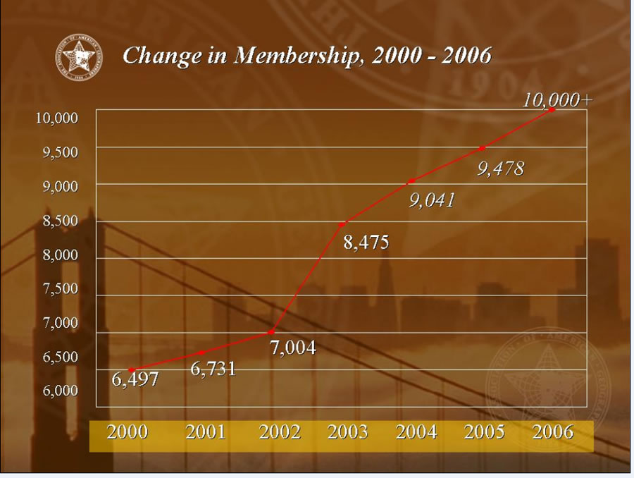 Membership in the Association of American Geographers (AAG) is climbing quickly. |
These are good times for the discipline of geography, at least in the United States. Membership in the Association of American Geographers (AAG) topped 10,000 people last year, nearly doubling since 2000. Attendance records also have been broken at the organization's annual meetings.
The news that "Harvard Returns to Geography" raised the profile of the field even more. The university in Cambridge, Massachusetts, hosted a one-day conference in May 2006 under that title and announced the launch of the Center for Geographic Analysis (www.gis.harvard.edu) as a first step. The center puts geographic information system (GIS) technology to work in many ways including providing GIS analysts to help students and faculty who are working on projects that require geospatial analysis.
Geography departments are expanding on many campuses, and the job market for new geography graduates is strong. The phrase "the new geography" is often heard in academic circles, particularly among senior administrators, many of whom are well aware of the changing image of the discipline.
Many geographers remember very different times—the late 1940s when Harvard closed its geography department or the closure of the University of Michigan geography department in the late 1970s. The domino effect that followed that latter decision deleted geography at the University of Chicago, Northwestern University, Columbia University, and several other schools. Many factors were involved: Geography was perceived as a hopelessly broad domain, demand for graduates was weak, and the discipline lacked a clear purpose and direction. Decisions by certain personalities were undoubtedly key factors, too.
There is no doubt geography's recent reversal of fortune owes much to GIS technology. Most, though by no means all, graduates of geography programs have been exposed to GIS and recognize the value that GIS expertise has in the job market. Several recent advances in geospatial technology have truly caught the popular imagination, starting with wayfinding sites such as MapQuest and progressing to today's Google Earth, Microsoft Virtual Earth, and many more. People are now able to see their own houses and neighborhoods in a global context and take the "magic carpet rides" that Al Gore talked about when he imagined a Digital Earth in 1998. Suddenly the most sophisticated GIS functions have become operations that a child of 10 can learn to execute in a few minutes. People are better equipped to see the relevance of GIS in many aspects of human activity and to appreciate the power that GIS provides to government, the oil and gas industry, disaster management, law enforcement, the military, conservation, and a host of other sectors.
But the relationship between GIS and geography is not as simple as it might seem. GIS once provoked quite hostile reactions from many academic geographers, as in 1988 when the then president of AAG described GIS as "nonintellectual expertise," seeing it as little more than rote button-pushing that had little to offer serious geographic scholarship. Much effort was expended by various leaders in the GIS community in the years that followed to convince academics there was more to GIS than mere technology—that new tools were often capable of stimulating new and interesting ways of thinking—and that GIS provoked new concern for many of the fundamental questions that had always troubled and intrigued geographers; questions, for example, about the importance of scale in GIS applications or about the errors and uncertainties that accompany any GIS analysis. Out of this effort emerged the new discipline of geographic information science (GIScience), which can be defined as the science behind the systems, the set of fundamental questions raised by GIS, or the research questions whose answers will define the next generation of GIS.
Today, GIS and the broader domain of geospatial technology have become so important that many geographers wonder if the train hasn't already left the station—whether in the long term a small discipline like geography, which in the United States is virtually unknown outside a small number of universities, can continue to claim this rapidly growing monster as its own. GIS courses are now offered in programs in surveying, civil engineering, computer science, anthropology, environmental science, and many other fields, particularly on campuses with no department of geography. Nevertheless, according to recent estimates, more than 50 percent of all GIS courses are still offered through departments of geography and geographers make up a healthy percentage of the global community of GIScience researchers.
GIS is a way of looking at the world, a lens through which the world is filtered as it is projected on the geographer's screen. As such, it has some very powerful attributes including precision, enormous computational power, the ability to create novel visualizations, and access to a vast range of analytic techniques that can test theories and hypotheses or search for patterns and anomalies. It places great emphasis on the spatial aspects of the geographic world, on the use of rigorous scientific methods, and on the importance of observation and evidence. All of these are powerful attributes, but within the broader disciplinary scheme they represent only a subset of the lenses that modern geographers now use. Some geographers argue that this emphasis on the spatial aspects is overdone; others maintain that geography needs alternatives to rigorous scientific methods; and still another group may reject observation entirely on the grounds that all observation is necessarily biased. Many GIScientists are intrigued by the possibility of extending GIS to include some of these perspectives. Others would see these debates as part of the normal give-and-take of any academic enterprise.
The Harvard story captures many facets of the recent history of geography and its relationship to GIS. When the department was abolished in 1948, the discipline, in the words of the French geographer Jean Gottmann, felt "a terrible blow . . . [from which] it has never completely recovered."
In the 1960s, Howard Fisher and others established at Harvard the Laboratory for Computer Graphics, which became the leading center for GIS research and software development through the 1980s. But the Laboratory went into decline and eventually closed, at least in part because it was never possible to establish a clear role for its activities within the university's broader intellectual enterprise. That role is now abundantly clear, with the adoption of GIS as a tool by many disciplines, the establishment of GIS programs, and the growth of GIScience. After two failures, will Harvard's latest effort succeed? The tea leaves seem to say yes, but only time will tell.
Michael F. Goodchild is a professor of geography at the University of California, Santa Barbara, and chair of the Executive Committee of the National Center for Geographic Information and Analysis. He is the author of many books and papers; teaches courses in GIS; and conducts research in GIScience, with particular emphasis on spatial analysis, data modeling, and errors and uncertainties in GIS data. Call 805-893-8049, fax 805-893-3146, or e-mail good@geog.ucsb.edu.