Immerse Yourself in GIS
By Aly Lawson, Esri Writer
For one week, in one place, Esri software users from around the globe will have everything related to geographic information system (GIS) technology at their fingertips.
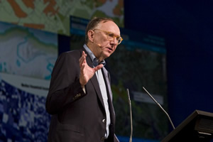 Esri president Jack Dangermond says ArcGIS 10 will make working with a GIS simpler. |
That week will be July 12-16, 2010, when thousands of people interested in geospatial technology will gather for the Esri International User Conference (Esri UC) at the San Diego Convention Center in California.
"GIS users continue to inspire us with the powerful work they do to make a real difference in the world, and the Esri UC is their forum for fostering creativity and sharing successful ideas," says Esri president Jack Dangermond. "The Esri UC provides everything users need, whether it's help with a project or understanding what the latest GIS technology can do for their organization."
It's also where Esri software users will learn about ArcGIS 10, due for release soon. "This is a very big release," says Dangermond, adding that it will be "cloud ready." Esri has a new relationship with Amazon Web Services to host ArcGIS in its cloud.
ArcGIS 10 will be demonstrated at the Plenary Session on Monday, July 12, and it will be the focus of many discussions, demonstrations, and workshops. Improvements in ArcGIS 10 will include tools to create, manage, and visualize time-aware data; mapmaking time-savers; enhanced editing and sharing capabilities; more powerful spatial analysis, especially with new tools such as location/allocation; the ability to perform editing, modeling, visualization, and analysis in 3D; improved access to imagery; and expanded availability of GIS in the field. Developers will also find it easier to build applications with Web APIs and Software Developer Kits (SDKs) included in ArcGIS 10.
"ArcGIS 10 simplifies working with a GIS. It puts the map up front," Dangermond says. Enhanced by cloud computing and Web services, "This is an easier, more accessible, and collaborative GIS." Dangermond will also share his vision of GIS during the plenary and talk about how many different industries use the technology to plan and make better decisions. Interesting and noteworthy guest speakers will give keynote presentations that will highlight the importance of geospatial information and technology.
A Full Schedule
The Esri UC offers a broad slate of events and activities that revolve around the latest geospatial technology developments and applications:
- 40 specialized tracks including those that focus on GIS implementation, mashups, disaster management, and industries that range from archaeology to water/wastewater utilities
- 600 user presentations
- 275 technical workshops
- 300 exhibitors
- 600 map posters and special displays
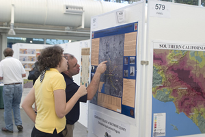 The Map Gallery will open immediately following the Plenary Session. The collection includes maps from all over the world. |
The Map Gallery opening will follow the plenary. Visitors will be able to browse the collection of maps that illustrate how GIS is used by a wide range of organizations in more than 100 countries. Groups such as the National Geographic Society and the Smithsonian will also present colorful map displays. The Exhibit Pavilion will house a variety of technology vendors. Attendees will be able to watch GIS demonstrations; speak to Esri staff about technical support; and see how geospatial technology is used in business, public safety, defense, utilities, and other sectors, in the Esri Showcase.
Unique Highlights
At a midweek ceremony, Esri will honor the winners of the Special Achievement in GIS (SAG) Award. Organizations will be lauded for their extraordinary use of GIS. Winners demonstrate vision and leadership in applying the technology to better serve society, such as enabling faster 911 responses and creating information-rich public Web sites.
GIS Kids Camp will provide school-age children with a way to explore GIS. And each year, the popular Thursday Night Celebration boasts a new theme.
Another draw will be the Spatial Outlet and bookstore, which will sell books about GIS including titles from Esri Press. Authors will also be on hand, signing books.
Play a Part
Attendees will make the conference a success and worthwhile for their peers. Here's how to participate:
- Give a Lightning Talk—a clear, quick, and informal presentation that's completed in five minutes or less. The deadline to submit a presentation is April 30.
- Have your videos, screen captures, and images featured in the plenary. The submission deadline is May 28.
- Share your paper and digital maps that illustrate the power of GIS. The submission deadline is June 14.
Submission details will soon be available at www.esri.com/uc.
The Esri UC will be open to all Esri GIS users. To learn more, register, and reserve special rate hotel rooms, visit www.esri.com/uc. Also, a customizable letter of justification to attend is available for download. The registration deadline is May 21.
Join the Online Conference Community
Connect with your GIS community online to share information about the conference. Communicate with other attendees on the Official Esri UC Facebook page. Follow the event conversation on Twitter @EsriUC. See and contribute photos by searching Flickr for the esriuc tag. And get the latest Esri UC updates and tips on the UC Insider blog.