May 13, 2010
OpenGeoscience Web Mapping Service Serves Free UK Geology Data
British Geological Survey Deploys Esri Technology to Deliver Geologic Data at Street Level
|
Images for Publication
|
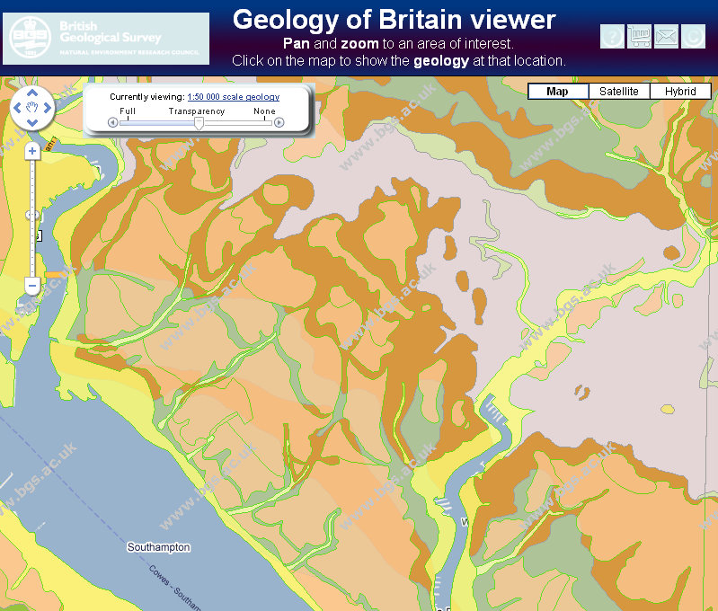
Redlands, California—The British Geological Survey (BGS) ushers in a new era of geologic mapping services with the launch of its OpenGeoscience Web site, built on Esri's ArcGIS technology. The Web site is the world's first Web map service built on vector data serving attributed geologic data for an entire country.
OpenGeoscience's Web interface gives site visitors viewing access to geologic maps of the whole of Great Britain at a scale of 1:50,000. Built on ArcGIS Server, OpenGeoscience enables resolution of geologic details to about 50 meters on the ground, which is essentially street level, a world first in terms of releasing countrywide attributed information at this scale.
"OpenGeoscience provides the public with a wealth of geological information and resources including maps, photos, digital data, research reports, and software," explained Richard Hughes, BGS director of information and knowledge exchange. "These can be combined with other environmental information to help people better understand their world."
BGS has been using Esri's geographic information system (GIS) technology since 1996 to bring together a wide range of information for its programs. GIS enables BGS data users to visualize geologic data and study relationships such as mineral extraction, land use, and environmental concerns. The geologic geodatabase can be used to underpin planning, development, mineral resource extraction, hazard mitigation, and more.
"This Web site is not just a piece of cartography," said Ian Jackson, BGS operations director. "OpenGeoscience is a fully interpreted database. When you hover over a piece of rock on the GIS map, you can use the identification tool to read what the rock type is. You can enter a UK postal code and address and get an assessment of the stability of the land under your house and, more specifically, the geology under your house."
BGS also uses the Web site to host geologic maps for the UK's onshore and offshore earthquake location information and samples of ground stability hazard maps. BGS has been collecting images of geologic interest from around the UK since 1891. Approximately 50 thousand of these images are also accessible through the Web site.
OpenGeoscience is highly popular, with 38 million hits the month it launched. The Web site is easy to use, and people enjoy visiting it to interact with data inside the geologic environment at no cost.
For more information about Esri's GIS solutions for geologic science and natural resources, visit www.esri.com/naturalresources.
# # #
Press Information:
Barbara Shields, Esri
Tel.: 909-793-2853, extension 1-2641
E-mail (press only): press@esri.com
General Information: info@esri.com