Many GIS departments are small teams expected to maintain data, respond to requests, build maps and dashboards, and support field crews. Because manual processes compete for limited hours in the day, GIS teams looking for breathing room often automate workflows. A well-automated workflow reduces errors, improves consistency, and frees up staff to focus on work that requires their expertise.
ArcGIS technology and its surrounding ecosystem offer a robust automation toolkit, even for those with no programming experience. Much of it is already available to organizations with an existing license.
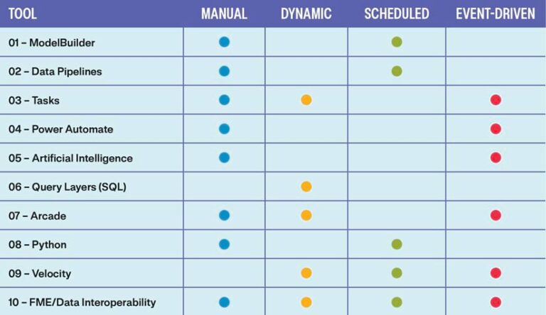
Here are 10 of those tools—from no-code visual builders to real-time streaming platforms, including the type of automation each enables. If you’re part of a GIS team looking to do more with what you already have, these tools are for you.
1. ModelBuilder
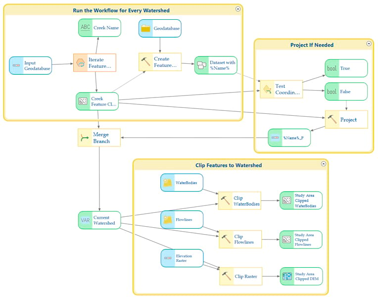
ModelBuilder has been a standard tool in ArcGIS Pro for over a decade and is often where geospatial professionals begin their automation journey. ModelBuilder is entirely visual and requires no coding knowledge, making it one of the most accessible entry points into automation. It allows geoprocessing tools to be dropped onto a canvas and chained together in a repeatable workflow. Once built, models can be scheduled, exported to Python, or published to ArcGIS Online or ArcGIS Enterprise.
Execution Type: Manual, Scheduled
2. ArcGIS Data Pipelines
ArcGIS Data Pipelines is a web-based extract, transform, and load (ETL) tool designed to assist with processing data in ArcGIS Online and ArcGIS Enterprise. Like ModelBuilder, it offers a drag-and-drop interface, making it accessible for users newer to geospatial ETL. It allows data to be loaded from feature layers, cloud databases (Snowflake, BigQuery, Databricks), cloud storage (Amazon S3, Azure Storage), files, and URLs.
Data can be transformed and cleaned using common ETL operations such as field mapping, field calculation, and spatial functions like buffer and intersect. Once it is loaded into your organization, it is ready for consumption.
Creating workflows with ArcGIS Data Pipelines requires a Creator or Professional user type, or privileges available through a Publisher, Facilitator, Administrator, or similar custom role.
Execution Type: Manual, Scheduled
3. Tasks
Tasks work within ArcGIS Pro and are designed to guide the user through a set of predetermined steps needed to complete a workflow. Tasks provide automation while keeping the human in the loop.
Geoprocessing steps can be configured as “click and run,” reducing the chance of steps being skipped or executed out of order. That guided consistency is especially valuable when handing off a process to a colleague or onboarding someone new, ensuring the workflow runs the same way every time, regardless of who runs it.
The dynamic and event-driven aspects of tasks work differently than other automation tools. A task must be started manually, but once underway, individual steps can advance dynamically or respond to events occurring in the map, such as a selected feature or an edit, before continuing to the next step.
Execution Type: Manual, Dynamic, Event-Driven
4. Power Automate
ArcGIS includes connectors for Microsoft Power Automate that allow users to automate data processing based on different events. For example, when a feature layer is edited, a webhook can trigger Power Automate to send a notification email, update a record in another system, or calculate a field value. Workflows can also be triggered manually, making Power Automate a flexible option for both on-demand and event-driven automation.
For government teams, among others, Power Automate is worth a closer look for one practical reason: Many of these organizations already run Microsoft 365, which means Power Automate may already be available at no additional cost. That lowers the barrier to entry compared to other tools on this list and makes it a natural first step for teams looking to bridge their GIS workflows with other business systems like SharePoint, Teams, or Outlook.
Execution Type: Manual, Event-Driven
5. Artificial Intelligence
AI tools are now integrated into ArcGIS in several ways. For some time, GIS professionals have been able to use AI tools within the Python framework to analyze data—extracting building footprints from aerial imagery or finding power lines from lidar data. AI tools have also been integrated directly into ArcGIS Online and ArcGIS Enterprise to assist with item descriptions, titles, summaries, and tags.
AI capabilities within ArcGIS are rapidly evolving. Machine learning and deep learning workflows are available in ArcGIS Pro and ArcGIS Online through tools like the ArcGIS Image Analyst extension and the arcgis.learn module in ArcGIS API for Python. AI assistant features also help users find content, generate code, and navigate the platform. For small teams, the most practical entry points right now are the metadata and content generation tools already built into ArcGIS Online. These are low barrier, immediately useful, and a good way to get familiar with how AI is being woven into the platform before exploring deeper capabilities.
Execution Type: Manual, Event-Driven
6. Query Layers (SQL)
If you are using ArcGIS Pro or ArcGIS Server, you can build query layers and publish them in your maps. Query layers are created using standard SQL and are designed to work directly with your relational database management system (SQL Server, PostgreSQL, Oracle) or cloud data warehouses (Snowflake, BigQuery, Redshift).
Note that your data does not have to be in a geodatabase; it can be in any supported database, including other business systems like a permitting system, asset management platform, or financial database. Because the data lives directly in the source system and the map simply reflects it, there is no ETL step or scheduled refresh needed, making query layers one of the lowest maintenance automations available.
Execution Type: Dynamic
7. ArcGIS Arcade
ArcGIS Arcade is a scripting language, usable across multiple ArcGIS products, that allows automation to be executed when and where it is needed. While many GIS professionals first encounter Arcade through labeling and symbology, its capabilities run much deeper.
Arcade powers attribute rules that automatically calculate or validate field values when data is edited, execute calculations that guide field crews through data collection in ArcGIS Field Maps, and generate pop-up expressions that dynamically format and display information in maps and dashboards. None of this requires a full script or scheduled job. This makes Arcade one of the most flexible tools in the stack, capable of manual, dynamic, and event-driven automation.
Execution Type: Manual, Dynamic, Event-Driven
8. Python
When working in ArcGIS, you have access to two Python libraries that can automate data workflows: ArcPy and ArcGIS API for Python. Each is aimed at slightly different scenarios. ArcPy is designed for geoprocessing and analysis, while ArcGIS API for Python works with your web GIS. Both allow data loading and analysis to be automated in a scriptable fashion. Because these are standard Python libraries, you also have access to the hundreds of modules and libraries built into the base version of Python.
Execution Type: Manual, Scheduled
9. ArcGIS Velocity
ArcGIS Velocity enables real-time and near real-time processing of data sent to and received from vehicles, Internet of Things (IoT) sensors, and other streaming sources. It allows for common data processing such as field mapping and calculations, along with basic geospatial functions like intersect, proximity analysis, and pattern detection. More advanced calculations can be performed using Arcade, making ArcGIS Velocity a natural companion to those scripting capabilities. It runs as an add-on capability in ArcGIS Online and is built into ArcGIS Enterprise.
Execution Type: Dynamic, Scheduled, Event-Driven
10. Feature Manipulation Engine/ArcGIS Data Interoperability
Esri partner Safe Software’s Feature Manipulation Engine (FME) is the Swiss Army Knife of geospatial automation. It can handle over 450 data formats, transforming them into the data you need and writing it directly into your enterprise geodatabase or hosted feature layer. It can also be used for spatial analysis and real-time and near real-time data processing. From sending and receiving emails to webhooks and event messages, FME can deal with everything you throw at it, making it the most versatile geospatial automation tool on this list.
Because FME is a third-party product, it requires a separate license outside the ArcGIS platform. However, if your team has access to it, FME is in a category of its own. Every automation type covered in this article (manual, dynamic, scheduled, and event-driven) is achievable within a single FME workflow, consolidating what might otherwise require multiple tools, languages, and skill sets. For a small team already stretched thin, that kind of versatility has real operational value.
If you can’t get a full FME license, Esri offers the ArcGIS Data Interoperability extension for ArcGIS Pro and ArcGIS Enterprise. This extension is built on the FME engine but offers a slimmed-down version of its capabilities.
Execution Type: Manual, Dynamic, Scheduled, Event-Driven