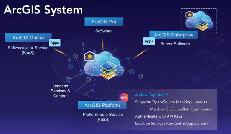
ArcGIS Platform provides a new option for developers to access powerful ArcGIS location services and high-quality geospatial content through this location platform-as-a-service (PaaS). The underlying services that power ArcGIS are directly available to developers building mapping and location-based applications. ArcGIS Platform complements the rest of the ArcGIS system ArcGIS Online, ArcGIS Pro, and ArcGIS Enterprise.
ArcGIS Platform is made up of three high-level elements:
- An excellent developer experience
- A comprehensive set of industry-leading location services
- A simple, transparent business model

Together, these elements provide an intuitive experience for accessing and using ArcGIS Platform.
Outstanding Developer Experience
ArcGIS Platform provides a premium developer experience that comes with the robust ArcGIS API for JavaScript and a set of APIs for mobile and desktop development. Developers using ArcGIS Platform can also leverage open-source mapping libraries, including Mapbox GL JS, Leaflet, and OpenLayers. ArcGIS Platform supports industry-standard authentication using API keys.
The ArcGIS Developers website provides resources and tools to help developers be successful with ArcGIS Platform. These resources include a developer guide describing productive workflows, extensive SDK documentation, more than 100 tutorials with a live sandbox that lets developers code and instantly see results, and a dashboard that gives detailed service usage and statistics. On the ArcGIS Developers website, a free account can be quickly and easily created to get started using these tools and resources.
A Collection of Location Services
ArcGIS Platform gives developers access to a comprehensive set of industry-leading location services: basemaps; data hosting; data visualization; geocoding and search; routing and directions; maps and data; and spatial analysis.
Esri delivers billions of basemap views around the world every day and ArcGIS Platform makes this rich resource available to developers.
Content can be hosted on ArcGIS Platform. This content can include services based on data as well as features; vector and image tiles; GeoJSON; spreadsheets; shapefiles; and text files stored in the ArcGIS Platform, which is secure, scalable, and performat. Note that developers retain ownership of any hosted data and telemetry data is not collected by Esri from users of apps and solutions developed using ArcGIS Platform.

All the tools for making beautiful maps in 2D or 3D—at scales from hyperlocal to global—and insightful visualizations are provided. The power of Smart Mapping is available to assist in creating intelligent maps by using just a few lines of code.
The geocoding service is powered by industry-leading reference data that comes from multiple authoritative sources that include commercial data providers, government agencies, and a network of Esri partners from around the world.
Services provide routing and turn-by-turn directions for single vehicles or for multiple vehicles to multiple destinations. The routing service has global coverage and generates localized directions. The route solver also takes into consideration current traffic conditions and dozens of restriction types.
Through ArcGIS Platform, developers have access to an extensive data library that includes demographic and statistical data (such as income, spending, market segmentation, and psychographic data), real-time live feeds, and high-resolution imagery from multiple commercial and community providers that can be used directly in apps or joined with proprietary data sources.
ArcGIS Platform provides hundreds of spatial analytics tools and operators—from geometric processing to attribute and spatial queries—and supports interactive analytical operations on 2D and 3D data. These spatial analytics tools can be used in two ways: on the client side by leveraging the power of devices and on the server side. Developers can also work with the big data, real-time analytics, advanced spatial tools, machine learning, and deep learning capabilities provided by the ArcGIS system.
These services can be used in many different deployment patterns for the web, mobile devices, desktops, and even system-to-system integration.
Consumption-Based Pricing
ArcGIS Platform is offered through a new business model that provides frictionless access and consumption-based pricing, so developers pay just for what they use. Getting started is as simple as signing up for an account at the ArcGIS Developers website to receive the free tier, which includes two million map tiles a month and thousands of other service requests, which can be used to search, geocode, and host data.
“With the release of ArcGIS Platform, developers now have access to professional-grade content and capabilities they can readily plug into their apps, allowing them to stay on budget while delivering enormous value by reducing time to market,” said David Cardella, Esri product manager for developer technologies.

