When the scale of a map or analysis gets altered, viewers often see patterns or features that were previously indiscernible. When looking at geography as a discipline—or at geographers, being the discipline’s representatives—it is typical to use broad scales. But at these meta levels, many practitioners get missed. They become invisible, hidden beneath a colonized and historically exclusive academe. At what scale(s) do geographers need to examine their own discipline to lift this veil?
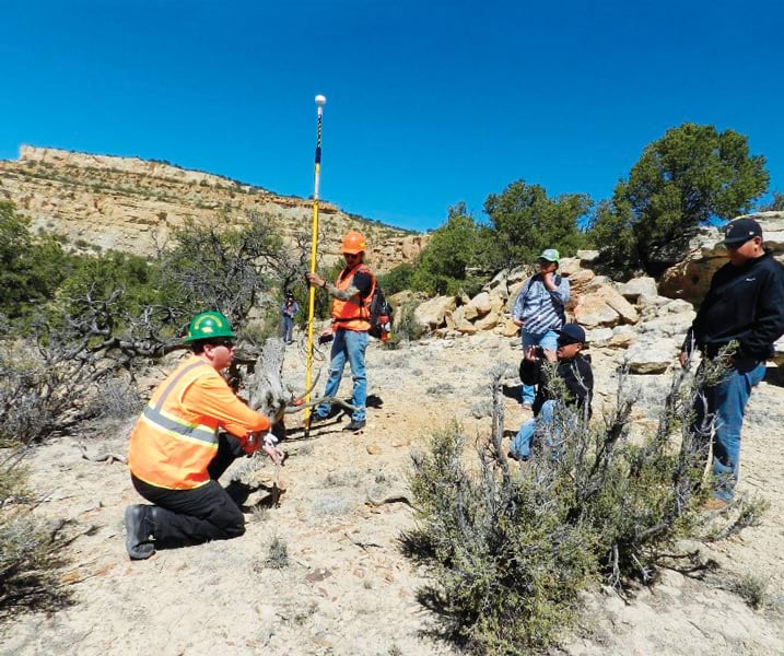
In March 2023, the American Association of Geographers (AAG) and Esri teamed up to sponsor 13 outstanding geography students and their faculty mentors from Minority-Serving Institutions (MSIs) in attending AAG’s annual meeting in Denver, Colorado. Nine of the students were from Tribal Colleges and Universities (TCUs). In addition to gaining exposure to the full range of conference offerings, the students received an orientation to the conference, recommendations for which sessions to go to, and an AAG staff escort—and even attended events in their honor. They met potential colleagues and new mentors and saw, through the thousands of sessions available, how many possibilities for study, careers, and community improvement there are within geography. Most of all, they got to experience what it feels like to be seen and appreciated at a large international conference. I believe and hope that this gave them a sense of belonging within AAG.
This balancing of scale—the ability to pay attention to the individual or a specific community within a larger group—is a perspective that defines the work of geography. Yet the very scale at which geographers sometimes view their discipline can blur or erase the experiences and needs of students and faculty from historically excluded groups, whether by race, ethnicity, sovereign status as Native people, gender, sexuality, caregiver status, income, or disability. The Bridging the Digital Divide program (which I helped develop at AAG, based on my experience supporting Indigenous students) that led these 13 bright geographers to AAG’s Denver meeting seeks to change the scale at which all geographers are viewed.
Bridging the Digital Divide was made possible through significant funding from AAG, the organization’s members, and Esri. Its initial intent in 2020 was to meet MSI students’ technology needs during the COVID-19 pandemic—funding laptops, internet service, software licenses, and enhancements to computer labs. Since then, the program has supported more than 20 MSIs, including 14 Historically Black Colleges and Universities (HBCUs) and 8 TCUs. But feedback from program participants indicated that historically overlooked students had many additional needs that must be addressed for them to thrive in school. The Bridging the Digital Divide committee took this into account when inviting the 13 MSI students to attend the Denver conference, considering their need for door-to-door transportation and childcare or elder care and providing all their meals and lodging during the meeting.

As a professor formerly at Tohono O’odham Community College, a tribal college in Arizona, and now at Arkansas State University, a research university where approximately one in five students is a member of a minoritized group, the experience of designing resources and networking opportunities for marginalized students got me thinking about the scale of attention paid to their experiences and needs. To support students who inhabit invisible places, institutions, faculty members, and mentors must see past larger-scale approaches to student services and ask the students direct questions, such as “What are the barriers to your academic success, and how can we help with those?” and “What do you really need?” (Any organization, no matter its size or purpose, should also ask these questions of members of historically excluded groups.)
In the big picture of geography, too many marginalized geographers are invisible—particularly at the student level. Some of this is because of literal geographic or institutional scale. For example, many Indigenous students live in communities that are located far from research universities and offer few educational choices. In other cases, financial barriers and anxieties that stem from social pressures prevent students from even enrolling in college and, if they do start, make it difficult to continue. Students who are among the first people in their families to attend college may also be rendered functionally invisible when school-provided guidance and resources don’t line up with their own lived experiences and needs. When some students leave their geography or GIS classes, for instance, they return home where there is no electricity or running water, much less Wi-Fi. These students often miss out on jobs and other opportunities and may struggle academically due to their circumstances.
What the geography discipline misses out on is how much each student has to offer. The experience at AAG’s annual meeting this year reminded me of the extraordinary perspectives and ingenious problem-solving skills that these students possess—garnered not only within their own generation but also from the stories, understandings, and technical knowledge they have inherited from their families and tribes. The students who participated in the AAG meeting brought their perspectives, life experiences, and questions to sessions, workshops, and meetings with mentors and potential future employers. They took home big ideas, insight, and exposure to new tools that they can use to address the issues that most interest them.
To me, this is what geography is all about: generating positive change within a community. Geography and GIS offer powerful tools to use to understand demographics, identify trends, maintain and defend tribal sovereignty, manage natural resources, and communicate traditional knowledge or place names to future generations. In ways that are very different but equally compelling, geospatial technologies can shed light on historic and current inequities in resource sharing, pollution, and a host of other community issues. Geographers and GIS practitioners owe it to these students and the communities they represent to put the tools of empowerment—geographic knowledge and GIS—into their hands. In my experience, enabling these students to collect, share, communicate with, and own their spatial data makes a huge difference in solving the issues that resource-limited, sovereign tribal communities face.
To do all this, geographers and those in geography-related disciplines need to radically reconfigure how they support their most financially and culturally vulnerable up-and-coming colleagues. This requires listening to students and scaling resources to the individual or collective needs of members of these communities. These young people’s perspectives and ideas are worth hearing and encouraging!
And this is everyone’s job. Whether you work at an MSI or other educational institution, a small startup, a large corporation, a local government, or a national agency, you are an important part of any ambitious change in this arena. No matter what your role is, there is something you can do. Simply bringing the scale of your own observations down to the more individual and community levels can yield great insight. So don’t be afraid to get into the details. Gaining a complete understanding of any situation requires exploring patterns up close as well as from a distance. A strong map to a more just and equitable discipline will hold true across many scales.
Find out more about AAG’s Bridging the Digital Divide program at Strengthening the Bridge Across the Digital Divide and consider donating to the cause at Bridging the Digital Divide.


