Urban planning departments direct growth within their cities. Through regulations and permit approvals, they evaluate land use and manage development. Naturally, changes to regulations can cause land-use conflicts, which developers are likely to challenge. That is why planning departments need to have a full record of changes to land use and zoning for parcels, complete with supporting documents that verify that regulations were applied correctly.
The City of Los Angeles Department of City Planning has simplified this process of keeping complete records. For more than 10 years, it has used ArcGIS Workflow Manager, Esri’s job tracking system, for database editing to ensure data quality.

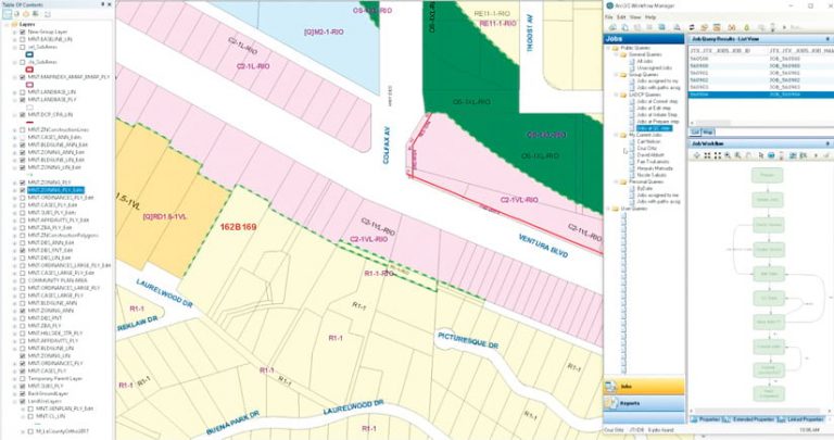
With Workflow Manager, users can trace edits and link to parcel documentation. This enables the department to maintain crucial metadata about edits in more detail than traditional geodatabase archiving alone. Additionally, because Workflow Manager is an extension for ArcGIS Desktop, staff interact with the data via the normal ArcMap interface—a program they already know. When they select an area of interest, they see all the job tracking identifiers associated with that location. From there, they can dive deeper to look at scanned maps, ordinances, history, and why any changes were made.
“ArcGIS Workflow Manager helps us respond to the most important people we serve: our citizens,” said James VanGerpen, director of the planning department’s Information Technologies Division. “The system allows us to research a parcel and its history across multiple edits and understand when and why certain actions took place. With Workflow Manager, we reliably answer citizen’s questions about parcels within an appropriate time frame and reliably inform the decision-making process.”
From Paper Workflows to Digital Ones
Using Esri technology, the Los Angeles planning department keeps track of more than 880,000 parcels in 58,000 zoning polygons and 53,000 general plan land-use polygons. Managing this database used to be overwhelming due to the number of changes made to the zoning and land-use datasets throughout the years.
Before implementing the digitized job tracking system, GIS editors’ work assignments were based on tiled coverages in ArcGIS Desktop—a total of 1,916 for the city. But supervisors could not decipher or trace edits made to the data. In the planning department’s early days, cartographers marked the changes they made to zoning and land use on paper maps, so if someone else took over the assignment, that person would have to follow a paper trail to find clues about ongoing tasks.
Around 2005, department leaders decided to modernize the data management system by implementing a GIS job tracking system. They wanted the technology to make editing more efficient, ensure healthy data, trace previous transactions, and have the agility to evolve and grow. With managers and directors driving the initiative, paper workflows were scrapped in favor of digital ones and staff were reorganized to improve data flows. This leadership-driven flexibility resulted in a successful implementation.
Constantly Advancing Workflows Improve Productivity
Early in the implementation phase, Esri staff and consultants from Esri partner NorthSouth GIS LLC (NSGIS) worked with the planning department’s GIS team to configure Workflow Manager so it matched the department’s editing requirements. The team created automated workflow standards to ensure data continuity, which involved adding custom tools to Workflow Manager using its robust API.

As the app’s technological capabilities advanced, the City of Los Angeles continued to work with Esri to improve editing performance. In 2009, each GIS specialist performed 700–800 edits in Workflow Manager on three tracked layers. Today, they each perform around 2,000 edits per year.
This is possible because the team has set up automated workflows for editing tasks, version management, geoprocessing, and archiving. The workflows create a version for each job or user, clean up old versions, and reconcile and post changes. What’s more, the centralized system streamlines transactional work processes and tracks feature edits. Now, each edit job takes, on average, 5 to 10 minutes to complete.
Since Workflow Manager was deployed in 2007, GIS specialists have executed around 300,000 transactions. That has more than doubled productivity.
More Accurate Data Makes Quality Control Easier
The planning department maintains 68 datasets that contain information on administrative planning boundaries, city planning case details, and more. Workflow Manager tracks data for the three most critical layers: Zoning, General Plan Land Use, and Centerlines.
The information in these layers is critical to public interest, since it informs how areas of the city can be used and developed, so it must be accurate and accessible. What’s more, the department makes zoning and property information publicly available via the Zone Information and Map Access System (ZIMAS) website.
To ensure the integrity of this public-facing spatial data, editors and supervisors from the planning department visually review it to document, correct, and verify its quality. They rely on the repeatable workflows in Workflow Manager to establish data standardization and consistency.
Tracking Jobs Is Effective and Reliable
Each year, the planning department tracks around 10,000 data edits. Using Workflow Manager, the GIS team creates weekly status reports for the IT directors that show all the information associated with each job. A custom reporting tool aggregates the number of edits made to each dataset, tracks the types of edits (e.g., whether information gets inserted, updated, or deleted), and creates a full history of actions by recording each job that gets edited within the three tracked layers. With this information, managers can see how productive GIS editors are over time.
The ability to track jobs like this in Workflow Manager has been especially helpful when the planning department has to address legal matters, including changes to zoning codes and discrepancies in old records. Because Workflow Manager accounts for every change made in the geodatabase, planning department employees spend less time and effort researching these matters. Additionally, for several cases that have been taken to court, the department has provided sworn declarations to demonstrate the competency of the changes made to its database records.
A Data Architecture That’s Ripe for Revisions
The Department of City Planning’s successful implementation of Workflow Manager has been vital to its data architecture—and that still resonates today.
Recently, the department launched Re:CodeLA, a comprehensive revision of the city’s existing zoning code system, which has been in use since 1947. The initiative seeks to make it easier for urban areas to evolve and change, and it requires the planning department to rezone every parcel throughout the city.
The GIS team anticipates that the new zoning code will triple the number of zones in its database. To make this a smooth transition and maintain continuity in the rezoning process, Workflow Manager will be instrumental in assigning tasks to each editor.


