For decades, Esri has championed global health work in countries with low- and middle-income economies. In the 1990s, Esri supported several World Health Organization projects by making location analysis and mapping a core part of key global health workflows. In the 2000s and 2010s, the urgency of these efforts ramped up due to two major events. The first was when Esri supplied key technological and personnel resources to the Global Polio Eradication Initiative to help vaccinate all children in countries where polio was still endemic. The second was the Ebola outbreak in West Africa in 2014, which demanded an unprecedented level of Esri support to map case clusters so that responders could prioritize resource allocation and contain the disease.
In the wake of these two major efforts, Esri went a step further to bolster the global health system in 2018 by creating a software grant expressly for ministries of health that are low on resources. This Health and Human Services Grant allowed government health agencies in 75 eligible countries that have low- and middle-income economies to apply to receive a bundle of free software.

These desktop and online GIS offerings equipped successful applicants with powerful foundational geospatial tools that could transform their daily work, whether related to disease surveillance, vaccine microplanning, or health facility accessibility analysis. Additionally, the two-year grant period gave these ministries time to assess their use of the software and engage in necessary budget planning to purchase geospatial resources at the end of the grant period. Once a ministry’s two-year period was complete, Esri offered it a low-cost bundle to use to continue to expand its geospatial work.
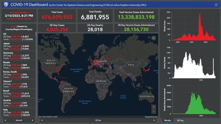
When COVID-19 brought daily lifestyles around the world to a halt in early 2020, global public health initiatives became unprecedentedly urgent. With the pandemic laying severe inequities bare, it became clear that empowering ministries of health—particularly in low-resource countries—was paramount. The COVID-19 pandemic also clarified how important location data and geospatial analysis are to public health. Map-oriented dashboards—such as the COVID-19 Dashboard from Johns Hopkins University’s Center for Systems Science and Engineering—proliferated. This helped public health officials understand that the geographic approach is critical to data modernization.
The ramped-up awareness of global health needs that has occurred over the last few years has led Esri to a crucial next step: reiterating and strengthening its commitment to global public health.
Making GIS More Accessible to Global Public Health Practitioners
Three initiatives are foundational to Esri’s updated vision on how to incorporate GIS more thoroughly into global public health work.
First, Esri has rebranded and enhanced its software grant to ensure that it reaches more countries around the world. Now known as the Global Public Health Grant Program, Esri’s flagship health award bears a name that reflects its intended goal—to equip ministries worldwide with geospatial technology that can be used to address the most pressing public health challenges. In addition, 36 countries have been added to the eligibility list, bringing the total number of countries with access to the award to 111.
This geographic expansion was driven by a more refined awareness of global health needs. While sub-Saharan Africa, the Middle East, and Southeast Asia remain central to many global public health concerns—whether because of tropical disease prevalence, a lack of public health infrastructure, or humanitarian crises—countries in the Caribbean, Latin America, and eastern Europe also demonstrate need based on health vulnerabilities.
Ministries that secure the grant get access to ArcGIS Pro and ArcGIS Online and receive two GIS Professional user type licenses; three Creator user type licenses; and access to ArcGIS Spatial Analyst, ArcGIS Network Analyst, ArcGIS Geostatistical Analyst, and ArcGIS Insights. This bundle empowers health workers to undertake the full range of geospatial tasks needed to prepare for, monitor, and react to public health crises, including field data collection, mapping and analysis, and internal and external communication.

Second, Esri has reinforced its commitment to global public health by creating its robust Health GIS Curriculum. Split into six sections, the curriculum leads participants through a series of self-paced tutorials that build GIS skills in the context of specific, fundamental health workflows. With tutorials available in six languages, this curriculum was designed for a global health audience and conceptualized as an integral component of Esri’s global health efforts. Taken together, the Health GIS Curriculum and the Global Public Health Grant Program represent a solid foundation for applying the geographic approach to public health work.
Third, Esri has solidified its support of DHIS2, an open-source health information system developed and managed by the HISP Centre at the University of Oslo in Norway. In the last few years, DHIS2 has become a major player in the global health space. More than 90 countries now use the platform in some capacity.
In 2022, Esri began partnering with DHIS2 to ensure that its platform and the ArcGIS system would be interoperable and that DHIS2 platform users would have an easy way to bring data into the ArcGIS ecosystem. To this end, Esri released a GitHub repository that facilitates the integration of DHIS2 content with ArcGIS Online using Koop, a flexible framework designed for building geospatial APIs. The result is a best-of-both-worlds approach that bridges the DHIS2 and ArcGIS systems and gives users optimal flexibility.
Keeping Up with Changing Health Challenges
These three efforts resonate with an emerging focus in global health: the impacts of climate change on public and personal health.
Earth’s warming is causing many negative health impacts to people around the world. Brutal and unprecedented heat waves are leading to higher death rates for vulnerable populations, such as the elderly and manual laborers. Megacities are enduring more days of extreme air pollution, leading to higher incidence of respiratory illness. In a particularly alarming shift, longer periods of warmth coupled with higher rainfall levels are leading to increases in vector-borne and waterborne pathogens and shifting the habitats of disease-carrying insects such as mosquitoes. Diseases such as cholera, malaria, and dengue fever are resurging and appearing in areas where they had been eradicated.
These shifting conditions demand increased public health resources—especially in the most vulnerable countries and even in countries where growing economic prospects have not led to dependable funding in health technology. With more robust access to Esri’s Global Public Health Grant, its curriculum, and the ability to easily pull data from a key health information management system into the ArcGIS system, ministries have a full range of tools to use to confront existing and future health challenges.
Giving ministry of health workers the best GIS tools is a critical step for modernizing health GIS at the national level. By doing this, Esri is demonstrating commitment to supporting global health in a multifaceted, holistic way. This approach enables ministries of health to undertake the critical work of keeping their populations safe from health threats of all kinds.
For more information about this grant or other global health topics at Esri, email me at lowen@esri.com.


