When organizations need to analyze geospatial data to craft efficient solutions, Esri partners can help. Read on to find out how three partners helped a botanical garden, an infrastructure company, and the State of West Virginia develop and improve their GIS-based workflows for greater accuracy and insight.
Growing a Digital Twin at Arizona’s Desert Botanical Garden
Located in Phoenix, Arizona, Desert Botanical Garden is a 140-acre living museum with more than 50,000 specimens of 4,500 native and nonnative plant varieties. With more than 500 rare and endangered species and an estimated 870,000 visitors per year, the nonprofit garden is a hub of education, research, exhibition, and conservation for desert plants, especially those of the Sonoran Desert.
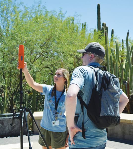
Until recently, staff at the garden managed the property and its specimens by using paper-based mapping workflows. Garden staff reached out to Esri partner Bad Elf, initially seeking survey-grade Global Navigation Satellite System (GNSS) receivers to help manage the botanical collection.
Now, the garden has gone digital, improving efficiency and helping keep the collection healthy. Assisted by Bad Elf, Desert Botanical Garden has migrated from its paper systems to a GIS-based digital twin.
Garden staff wanted to increase their digital collection of plants and assets. Previously, the collection was only partly digitally mapped, and the goal was to digitally map the entire garden. By going digital, staff hoped Desert Botanical Garden would improve efficiency, particularly by mapping facility infrastructure such as water lines and similar assets for maintenance purposes.
The Bad Elf team went on-site to demonstrate how Bad Elf GNSS receivers could work in the garden’s high-density planting conditions, unique to species in the US Southwest. Using ArcGIS Field Maps, the team demonstrated practical data collection techniques that met all of the staff’s requirements. Bad Elf also trained the staff in high-accuracy geospatial field data collection, emphasizing workflows and helping ensure that all the data collected uses GNSS metadata.
In addition, the Bad Elf team taught garden staff how to construct field layers using appropriate projections to ensure that all data would be properly referenced. Staff learned how to deploy field data collection layers and web maps in Field Maps and how to use ArcGIS Pro as their primary geodesign management tool. Combining Field Maps and Bad Elf Flex GNSS receivers, training concluded with staff constructing and deploying Field Maps layers designed for individual duties such as maintenance, planning, and research.

Moving away from paper maps enabled garden staff to have a complete digital twin of Desert Botanical Garden’s plants. Now staff can run plant health reports; assign maintenance and monitoring tasks to high-density plantings; and keep track of plant species’ health, location, and quantities.
The garden’s geodatabase also supports data collaboration with the US National Seed Strategy, a Bureau of Land Management program that guides the development, availability, and use of seeds needed for restoration efforts. Participation in this program gives the botanical garden access to federal funding to create and manage a national revegetation plan for federal and nonfederal land.
In the future, the garden’s Esri-based digital twin will not only help staff keep the garden healthy but also provide data that could aid conservation efforts in desert areas far from Arizona.
Closing the Distance Between Small Communities and Fiber Backbones
Infrastructure company Arcadian Infracom builds and operates long-haul fiber routes through rural and tribal lands in the United States, enabling improved broadband access and economic development in underserved communities. Developing unique routes that support Arcadian’s broadband access and diversity objectives is complex and requires considering many location-based elements.
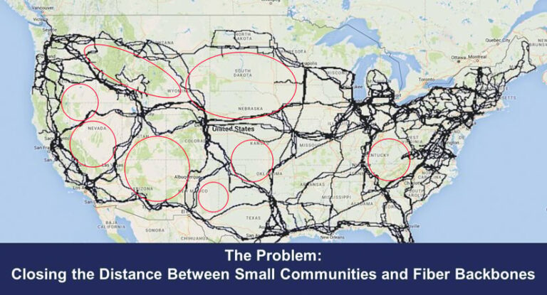
Enterprise GIS became critical for staff at Arcadian to analyze, create, and manage rights-of-way. But implementing and administering ArcGIS Enterprise was complex from resource and cost perspectives. So Arcadian management reached out to CyberTech Systems and Software to help get ArcGIS Enterprise up and running and ensure that its use met the infrastructure company’s key business objectives.
The CyberTech team acted quickly, first engaging with the Arcadian Esri account representative. Esri approved Arcadian’s application to join the ArcGIS Telecom Management enterprise agreement program, which provides the organization with key GIS capabilities, plus discounts on training and additional licensing.
CyberTech also set Arcadian up with the CyberTech Managed ArcGIS Cloud Services offering. This security-first managed service subscription for ArcGIS Enterprise provided Arcadian with a cloud computing environment, ArcGIS Enterprise implementation, and end-to-end service-level agreement-based administration. From start to finish, CyberTech completed Arcadian’s ArcGIS Enterprise implementation and setup in just six weeks.
With an ArcGIS Enterprise environment fully functional and accessible, Arcadian’s broadband planners use the power of location for right-of-way analysis, creation, and management. Now that Arcadian employs the power of integrated information about areas under consideration from a location perspective, staff are able to analyze the geographic elements of each project and how they might impact routes, which saves the company time and resources.
CyberTech continues to provide Managed ArcGIS Cloud Services to Arcadian, ensuring that the company’s spatial resources are fully functional, up-to-date, and available. In addition, CyberTech’s engineers assist with streamlining processes and automating right-of-way-related functions. Today, the partnership between CyberTech and Arcadian remains mutually beneficial, driving success for both companies.
Improving Internet Connectivity with Ookla Speedtest Data and ArcGIS Survey123
Internet connectivity is necessary for education, economic growth, and quality of life, so ensuring universal access to fast and reliable internet is a priority for state governments. In 2021, West Virginia governor Jim Justice announced the Billion-Dollar Broadband Strategy, a plan to invest more than $1 billion in public and private funding to improve broadband connectivity to homes and businesses throughout the state.
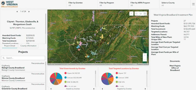
In 2023, the cost of this plan—the largest broadband investment in the state’s history—exceeded $1 billion and prompted the West Virginia Department of Economic Development and the West Virginia Broadband Enhancement Council to prioritize funding allocation. However, a lack of network performance data, along with West Virginia’s varied Appalachia mountain topography, interfered with determining where to focus connectivity improvements.
While federally published maps such as the Federal Communications Commission’s National Broadband Map help visualize connectivity needs, their data does not always reflect constituents’ true, everyday internet experience. With a need for comprehensive, unbiased network performance data, project managers leveraged Ookla’s crowdsourced Speedtest data to better understand the state’s broadband availability and performance. They based their research on the many West Virginia residents who use Speedtest to monitor their internet performance.
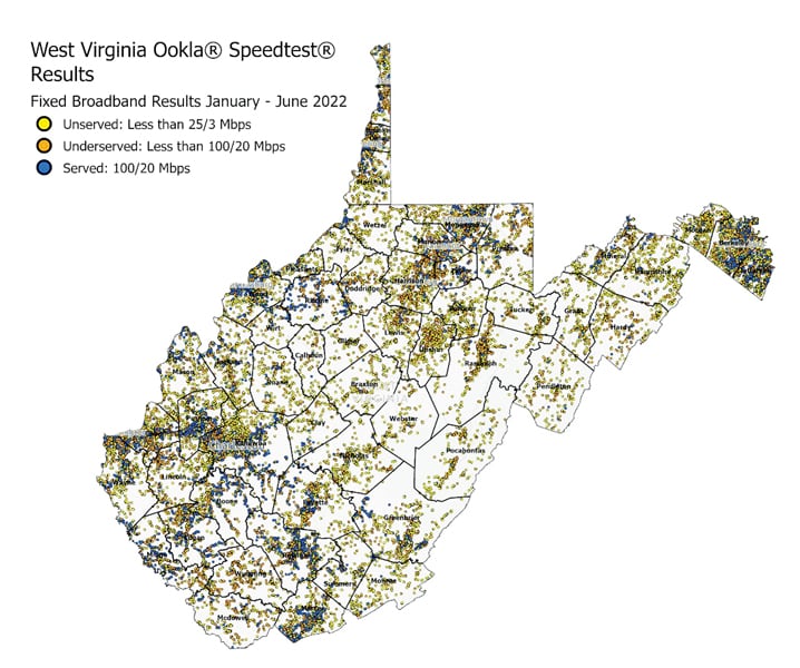
Using ArcGIS Online and ArcGIS Pro, the department conducted a multicriteria spatial analysis using hundreds of thousands of Speedtest results, Federal Communications Commission data, and related layers. This enabled the department to accurately visualize statewide connectivity while analyzing quality-of-service measurements such as upload and download speeds. The department was able to identify more than 271,000 underserved and unserved locations that had not previously been reported, helping target funding where it was most needed.
To enhance crowdsourced Speedtest measurements, the department and the council now encourage residents to continue testing their broadband performance using an integrated Speedtest and ArcGIS Survey123 questionnaire. This allows the state to associate Speedtest measurements with ISPs, location type, and service affordability to understand gaps in broadband adoption.
West Virginia continues to use Ookla crowdsourced data and ArcGIS tools to track network buildouts, monitor adoption and speeds in focus areas, and make informed funding decisions as more grants are awarded. Now, Ookla’s ArcGIS technology-hosted layers allow government offices nationwide to rapidly map broadband and mobile network performance datasets, analyzing crucial speed and quality-of-experience metrics to help ensure equitable connectivity development.
