When organizations need help upgrading technology, managing and analyzing large amounts of data, and synchronizing systems, Esri partners can help. Their expertise in ArcGIS technology, GIS consulting, and training relieves pressure on organizations to do everything themselves and ensures that staff members have the knowledge and skills they need to continue the work going forward.
Read on to find out how four partners helped three utilities and one city take their GIS data and implementations to the next level.
Offline, Map-Based Data Improves Digital Field Experience
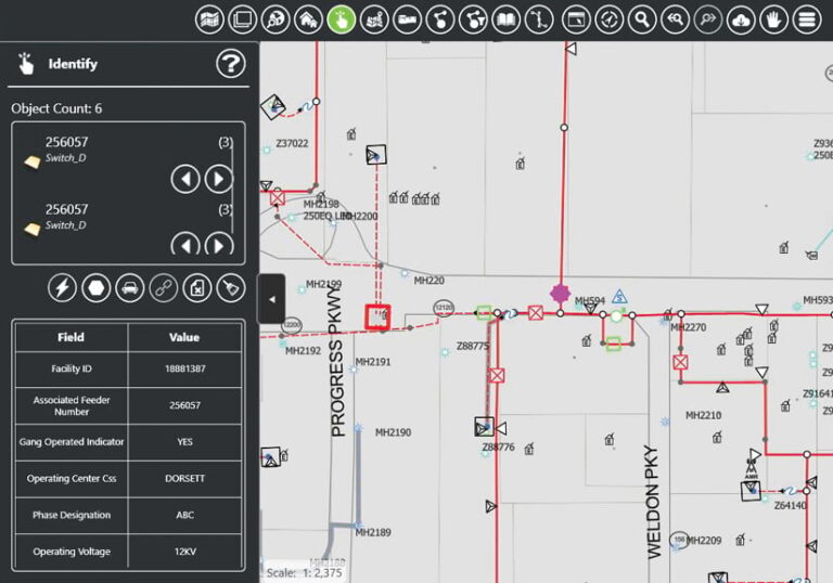
At electric and gas utilities like Ameren, it is important for mobile crews to have easy access to current, accurate, GIS-based asset data so they can inspect, maintain, and repair equipment efficiently and correctly. But for too long, staff at Ameren relied on mobile mapping solutions that were only updated quarterly, resulting in outdated information—or data that could only be used online—which was impractical for workers on the go. And because Ameren’s existing work management tool didn’t have an integrated map, mobile crews struggled to gain spatial reference as to where their work needed to be done.

As the Missouri-based utility prepared to roll out an improved digital field experience initiative to its 4,000 mobile workers—which included multiple software updates to simplify how dispatch areas and service territories were managed—it became clear that having a reliable and field-ready mapping app was vital. To address this challenge, Ameren partnered with Epoch Solutions Group based on the strength of its EpochField tool and the company’s extensive GIS consulting experience.
Ameren implemented the scalable, highly configurable EpochField mobile mapping solution, which is built on ArcGIS Runtime SDK for .NET. Using the SDK’s Xamarin libraries, the app runs on Windows 10, iOS, and Android devices. Now, mobile crews at Ameren can use EpochField to work offline or online, download and view updated GIS data on demand, and draw accurate field diagrams with the map markup tool. Thanks to seamless integration between EpochField and ClickSoftware’s Click Field Service Edge (CFSE), mobile workers can find and complete tasks either through legacy, text-based searching or by using the intuitive map interface in EpochField. Additionally, with user authentication enabled throughout Ameren’s on-premises ArcGIS Enterprise portal, end users enjoy a convenient single sign-on experience.
Equipped with an offline, mapcentric mobile solution configured to their unique needs, mobile crews at Ameren are now completing their daily work—from routine maintenance and inspections to making repairs and dealing with service outages—using the most up-to-date information available. Despite deployment challenges caused by the COVID-19 pandemic, Ameren continues to roll out this powerful solution across its mobile workforce, transforming how gas compliance representatives, substation technicians, and electric distribution specialists deliver excellent service.
Easy-to-Visualize, Comprehensive Analysis Kick-Starts Vision Zero
The City of Las Vegas, Nevada, recently kicked off its Vision Zero action plan, which seeks to eliminate traffic fatalities and serious injuries by 2050 while making mobility safer, healthier, and more equitable. The plan is a multidisciplinary approach that brings together local traffic planners and engineers, policy makers, safety stakeholders, and public health professionals to collaboratively address vehicular, pedestrian, and bicycle safety.

Before Las Vegas could put its Vision Zero action plan into practice, however, city staff members needed to first understand the locations and types of crashes occurring on local roadways. They sought to do this through a Citywide Intersection Crash Mitigation Program (CICMP) and approached Wood Rodgers, Inc., for help. The goal of the CICMP was to identify intersections throughout Las Vegas with the highest number of crashes and the highest crash rates, focusing on fatal vehicle-pedestrian and vehicle-bicyclist crashes.
Working with the city’s Transportation Engineering division, the GIS group at Wood Rodgers managed and analyzed large amounts of traffic data, automated the presentation of results, and quickly shared the outcomes with stakeholders.
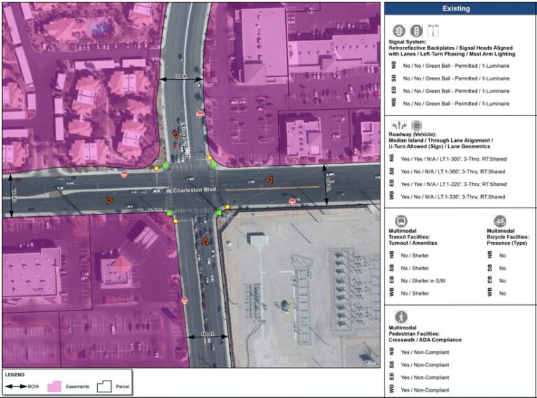
Team members used ArcPy to categorize nearly 60,000 crash-related data points by intersection and segment location. This data was presented in an easy-to-read infographic that contained charts and figures related to the crashes. Next, the team employed the cluster and heat map analysis functionality in ArcGIS Pro to determine the 10 intersections in Las Vegas with the highest number of crashes. The team then used ArcGIS Survey123 to collect existing-conditions data for these intersections.
As each step of the project was completed, the team at Wood Rodgers added the results to narratives built with ArcGIS StoryMaps and ArcGIS Online. These served as comprehensive, living documents that City of Las Vegas employees and other stakeholders could use to determine areas of focus and need. The interactive, map-based stories helped project participants and decision-makers easily visualize areas of concern so they could make informed choices on where to implement the most-needed improvements.
Synchronization Offers a Better Way to Manage Work Order Geometry
Marin Water is a publicly owned and managed water utility serving more than 190,000 customers in central and south Marin County, California. Like many utilities, Marin Water manages its asset inspection, maintenance, and repair work in an enterprise resource planning (ERP) system that’s separate from its GIS—in this case, SAP ERP Central Component (ECC).

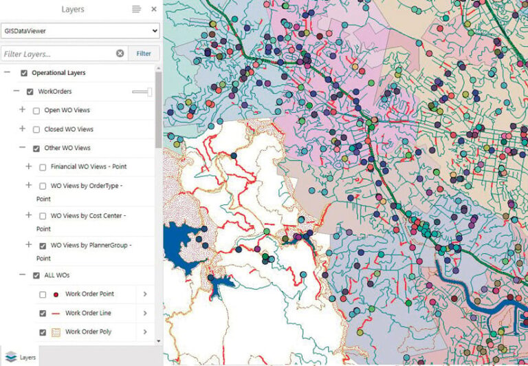
In 2018, Marin Water worked with Locana—known then as Critigen—to codevelop an Esri-SAP synchronization tool that used Python and a .NET add-in to keep asset data synchronized between ArcGIS and SAP for the entire water network. To build on that work and spatially enable SAP work orders and notifications, Locana updated the existing synchronization tool so that Marin Water’s SAP database would automatically sync with the utility’s geodatabase in ArcGIS Enterprise. That enabled the geodatabase to incorporate work orders from SAP and assign any associated assets with an initial location and geometry in GIS. The tool also monitors changes made to work order data in SAP. It synchronizes them with the geodatabase via automated processes and sends scheduled reports, which helps maintain data integrity.
Synchronizing work order data with ArcGIS has allowed Marin Water to build a user-friendly, map-based interface that empowers users to more easily manage geometry changes in work orders. For example, if a work order for a leak gets assigned to the wrong asset prior to excavation, it’s now simpler for staff members to correct the geometry of that asset postexcavation. All they have to do is click a custom button within SAP that brings up a web map and then follow a quick workflow for creating, changing, or viewing the geometry of the work order.
Having the ability to view and manage SAP work orders and notifications across the utility’s enterprise GIS implementation provides significant benefits to Marin Water. For annual maintenance and inspection programs, like valve turning, supervisors and managers can now view each program’s progress on a map. Staff at the utility can also gain deeper insight into suspected problem areas and types of equipment by viewing historical repair history according to asset type and/or geography.
“By leveraging our previous investment with [Locana] to develop the Esri-SAP synchronization framework, we were able to quickly update the tool to synchronize additional work order data with GIS,” said Marin Water GIS coordinator Gavin McGhie. “We built a user-friendly Esri map our employees can use to manage work order geometry.”
Move to ArcGIS Utility Network Reduces Headaches and Paper Cuts
The City of Hastings, Nebraska, administers water, sewer, gas, and electricity services for approximately 25,000 residents who depend on quick response times. For years, the city has relied on a geometric network within ArcGIS Desktop to manage and maintain its water utility infrastructure. But as the city has grown and its needs have evolved, city employees realized that they required more advanced GIS capabilities.

With the geometric network, staff members used paper maps to do data collection. Communication—both internally and externally—was slow and inefficient. That said, the idea of doing a full migration to ArcGIS Utility Network was daunting, considering how dependent employees were on the geometric network for conducting day-to-day operations. When Esri announced last year that it would move fully to Utility Network by 2026, however, the initiative to get Hastings off its geometric network and working in ArcGIS Utility Network got fast-tracked.
That’s where Axim Geospatial, which holds the Utility Network Management Specialty, came into play. A team at Axim worked with City of Hastings staff members to migrate all their crucial data to Utility Network. Because this was done during the COVID-19 pandemic, it entailed working both remotely and on-site—an adjustment for everyone. Five days on-site, plus additional remote work, gave the team at Axim enough time to learn the city’s needs, address its most pressing problems, and accomplish everything that needed to be done.
Learning new software can be challenging, so to ensure that the City of Hastings had the institutional knowledge it needed to maximize its Utility Network investment, Axim provided in-depth training that included knowledge transfer, collaboration, and tools for success. This empowered city staff members to understand the workflow well enough so they could implement it themselves for additional utilities.
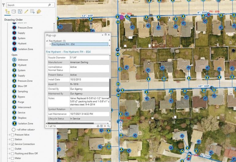
The City of Hastings has now fully migrated its water utility data to ArcGIS Utility Network. Having switched from paper maps to digital solutions for collecting data has greatly improved efficiency and accuracy—and has simultaneously reduced headaches and paper cuts. Now that data in the field is collected in real time, communication within and from the city has become more responsive, which has increased job satisfaction among city employees and had a positive impact on the community.

