Each year, Esri acknowledges outstanding partners that deliver innovative solutions and services to extend the ArcGIS platform and foster positive change at organizations around the world. At the 2018 Esri Partner Conference, held in March in Palm Springs, California, Esri recognized 13 partners in 12 award categories that reveal just how skillfully these companies are amplifying The Science of Where.
This year’s award winners are tackling some of the world’s toughest challenges, developing remarkable GIS solutions that help with community engagement and push GIS into new markets, all while demonstrating best practices in business.
Get to know these Esri partners and their solutions a bit better.
Bringing Insights
Value Lab
A management consulting and IT company focused on retail and commercial markets, Value Lab uses ArcGIS to help production, distribution, and services organizations gain a better understanding of how their businesses function. Value Lab’s users can prioritize their sales territories by intersecting market potential indicators with brand coverage assessments to reduce risks, make smarter operational decisions, and increase revenue.

Innovating Solutions with New Capabilities
GISinc
GISinc helps its users in the government and commercial spheres solve complex problems by employing groundbreaking location technology. Its GeoIoT platform combines GISinc’s services and ArcGIS software with partner-developed Internet of Things (IoT) solutions to better leverage analytics, positioning, and mapping. Recently, GISinc used ArcGIS Enterprise to help Independence Township, Michigan, implement a new dashboard, visible on any device, that monitors all its location-based systems—from the ArcGIS platform and GISinc’s own solutions to software from other vendors like Esri partner Cityworks. Now, the township can access more information, monitor activity, and make smarter decisions, all from a single system.

Turning Pro
Data East, LLC
Data East’s popular XTools Pro solution has more than 80 features that extend the capabilities of ArcGIS Desktop. But more and more of the company’s 10,000 software customers and 20 partners around the world began requesting that XTools Pro be migrated from ArcMap to ArcGIS Pro. The company did just that, creating the new XTools AGP ArcGIS Pro add-in. More than 2,500 XTools Pro users have already started using XTools AGP. (Read the ArcNews article that details how Data East migrated its tool from ArcMap to ArcGIS Pro.)

Creating Realistic Context
vrbn AG
The team at vrbn, which provides consulting services to urban planning and design firms, applies its 3D visualization expertise to help users get a realistic view of historical, current, and future models of various cities. Specifically, the 3D landscapes generated by vrbn’s MasterPlanner tool—an add-on to Esri CityEngine—give city planners a deeper understanding of the potential effects of their proposed developments on the surrounding environment.

Taking GIS to the Field
Frontier Precision, Inc.
With its exceptional team of natural resources professionals, Frontier Precision addresses a wide range business needs—from surveying and mapping to administering water resources and performing mosquito and vector control. To help users achieve their objectives, the company develops a comprehensive work plan that defines each user’s needs before recommending the appropriate geospatial solutions—including ArcGIS apps for the field. For instance, Frontier Precision assisted the nonprofit Comprehensive Life Resources (CLR) in putting together a survey with Survey123 for ArcGIS to collect data on homeless activity in Tacoma, Washington. (Read more about this in ArcNews.)

Delivering in Real Time
OSIsoft, LLC
OSIsoft provides operational intelligence to users who manage energy production and infrastructure—so, for them, having real-time situational awareness is vital. With PI System for ArcGIS, OSIsoft users can apply spatial analytics to their real-time data to optimize organization, reduce downtime, lower costs, and increase reliability. (Read the ArcNews article about how Peak Reliability uses PI System to manage electricity output throughout the Western Interconnection of the North American Grid.)

Driving Enterprise Platform Adoption
GEOMAP-IMAGIS
GEOMAP-IMAGIS offers comprehensive enterprise geospatial solutions and services to local governments and utilities, and it is currently ushering GIS into new markets, including real estate. To make it easier for its users to incorporate multiple solutions into their work and take advantage of the latest advances in GIS, GEOMAP-IMAGIS is working in close collaboration with Esri France to migrate its entire product suite to the ArcGIS platform.

Quick to Market
GeoDecisions
The spatial IT experts at GeoDecisions have made it a priority to align with Esri technology—so much so that they are able to tap into early releases and quickly configure the ArcGIS platform in ways that make their solutions valuable and affordable for their local government and commercial users. All seven apps in the GeoDecisions AppSuite run on ArcGIS as a common platform, so users can easily integrate them into their existing systems. That is what the Pittsburgh Water and Sewer Authority did when it used GeoDecisions’ Notify app to pinpoint who in the city would likely be affected by a water event, such as a water main break or wastewater runoff, so it could notify them of the potential harm via text, email, or a phone call.

Being Release Ready
Geocom Informatik
Geocom Informatik—a management consulting firm for users in the utility, transportation, logistics, energy, planning, security, and local government fields—always ensures that it is working with the most up-to-date releases of the ArcGIS platform. To deliver its robust offerings, the company continually upgrades its solutions and services, including GEONIS, which helps users incorporate GIS and spatial data into their existing organizational processes and systems.

Partnering to Lead New Strategies
SSP Innovations
RAMTeCH
Merging their expertise in the utilities sphere, SSP Innovations and RAMTeCH worked together to launch the Utility Network Advantage Program (UNAP), a comprehensive way for users in the utilities, oil and gas, and telecommunications fields to implement the ArcGIS platform and transition to the ArcGIS Utility Network Management extension. UNAP takes into consideration each user’s current business framework, data, and processes and determines how to best take advantage of the new benefits provided by ArcGIS Utility Network Management.

Leading Web GIS Transformations
Pro-West & Associates, Inc.
Pro-West & Associates, known for its specialized GIS consulting and data services expertise, is transforming the way governments and utility, mining, and agricultural organizations access and share information through Web GIS using ArcGIS Online. For instance, the company helped Pope County, Minnesota, build an open data hub that promotes citizen engagement and offers people access to problem-solving tools, such as datasets linked to emergency services, the environment, and land records.

Engaging Communities
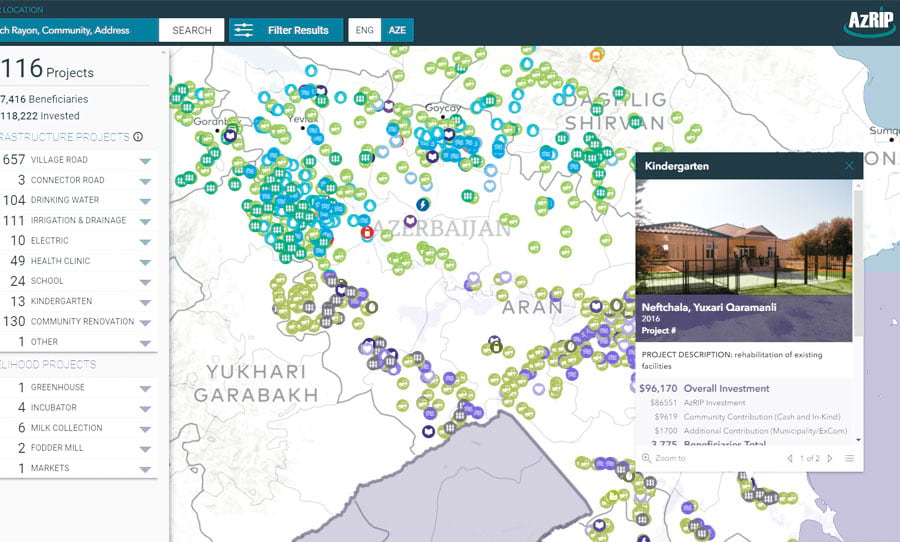
Blue Raster, LLC
Blue Raster helps build strong communities by bringing government agencies, nonprofit organizations, businesses, and citizens together in collaborative environments that revolve around interactive mapping solutions, data analysis, and implementation and development services. Using the ArcGIS platform to deliver both web and mobile solutions, Blue Raster aids nontechnical users in visualizing, understanding, and solving complex problems. For example, the company recently collaborated with the World Bank and the Azerbaijan Rural Investment Project (AzRIP) to develop maps that give citizens insight into local community projects and help stakeholders make data-driven decisions.