When organizations need to improve operations, update planning procedures, and streamline data management, Esri partners can help. See how four partners aided two utilities, a roadwork planning commission, and a county government in updating their GIS implementations so they could remain agile while continuing to grow.
Modernizing a Rural Utility
The Tohono O’odham Utility Authority (TOUA) in southern Arizona operates a full network of utilities including electric, water, and telecommunications. For years, staff at TOUA struggled to maintain existing plant records and develop systems to aid with operating the authority’s networks and dispatching field crews. They relied largely on paper maps and handheld GPS devices that weren’t set up to collect important attribute information about TOUA’s assets in the field.
Seeking to accurately map assets and expand the authority’s broadband network by deploying fiber optics to the villages within the Tohono O’odham Nation, a Native American reservation, TOUA partnered with Palmetto Engineering and Consulting for engineering and GIS services. After conducting a full data review, the team at Palmetto determined that TOUA needed to do a complete inventory of its field assets.
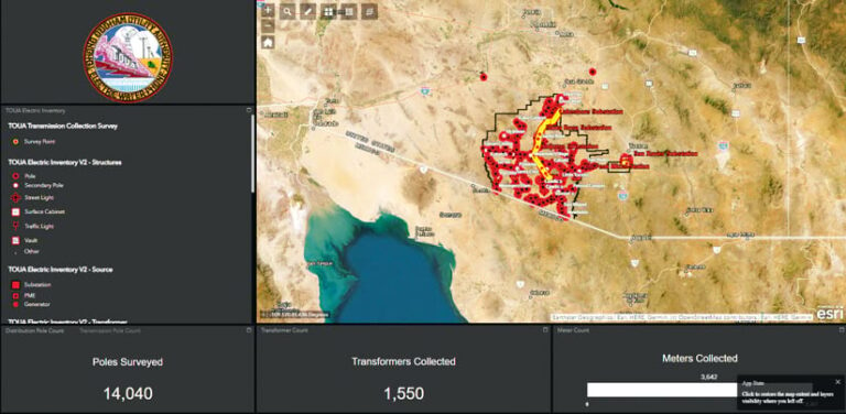
Using high-accuracy GNSS devices, ArcGIS Online, ArcGIS Pro, and ArcGIS Field Maps, the Palmetto team worked with field personnel at TOUA to inventory the utility’s existing infrastructure and conduct broadband field design. The resultant map showed TOUA’s current field assets, as well as what would be added in the future. Working with Palmetto to collect field data and apply GIS practices in the real world enabled team members at TOUA to understand their GIS as it was being created and take ownership of their workflows so they could be more self-sufficient. Palmetto also provides ongoing training to help the TOUA team evolve its records system as Esri technology advances.
The partnered collaboration options in ArcGIS Online have allowed Palmetto to provide ongoing engineering services and assist TOUA in procuring grant funding. They also enable Palmetto to aid TOUA in conducting broadband data collection reporting for the Federal Communications Commission, a requirement for the utility to continue expanding broadband into the underserved communities of the Tohono O’odham Nation.
As TOUA’s broadband network buildout proceeds, the partnership between the authority and Palmetto remains fruitful. The GIS that’s in place today allows TOUA to assess damages in a timely manner and restore services to customers within the reservation when needed. Additionally, the ongoing GIS training and engineering services that Palmetto provides to staff at TOUA help employees in the authority’s Network Operations Center monitor and operate the various services it provides to the reservation.
The teams at Palmetto and TOUA continue to develop new solutions and training to support the authority’s operations and help build a brighter future throughout the Tohono O’odham Nation.
Matching a Customer’s Needs
The Scottish Road Works Commissioner (SRWC) aims to improve the planning, coordination, and quality of roadwork performed throughout Scotland. When road authorities and utility companies need to coordinate and plan a project, they enter the details in the Scottish Road Works Register (SRWR).
Since 2006, Esri UK partner Symology has provided the SRWR to the SRWC as a hosted solution. The solution was integrated with GIS using ArcGIS Engine as the underlying mapping platform. While this version of the SRWR was robust and feature rich, the SRWC eventually required a more modern, platform-independent user interface.
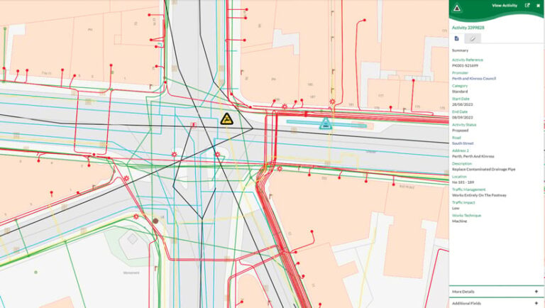
For several years, Symology had been working on creating a new platform for its products and services called Aurora. It is a browser-based solution that’s hosted in the cloud using ArcGIS Enterprise running on Microsoft Azure. Aurora is accessible from any device, and its background mapping is served out from ArcGIS Online.
The new solution matched SRWC’s needs, and in July 2020, the organization agreed to be the first customer to implement the new platform. Aurora’s flexibility immediately proved invaluable for SRWC, as members of the SRWC community adapted their working practices during the COVID-19 pandemic. The solution enabled more than 3,000 users to work remotely from any web browser.
In addition to implementing Aurora’s main, browser-based user interface, the team at Symology provided mobile apps for Android and iOS using ArcGIS Maps SDKs for Native Apps. This enables users to record inspections, document when roadwork projects begin and end, and view maps of underground equipment—all out in the field. More than 60 percent of roadwork inspections in Scotland are now recorded using mobile devices, increasing the accuracy and timeliness of data in the SRWR.
Since Aurora went live in Scotland, over 50 additional companies, agencies, and local highway authorities across England and Wales have also implemented the platform.
Improving Operational Efficiency
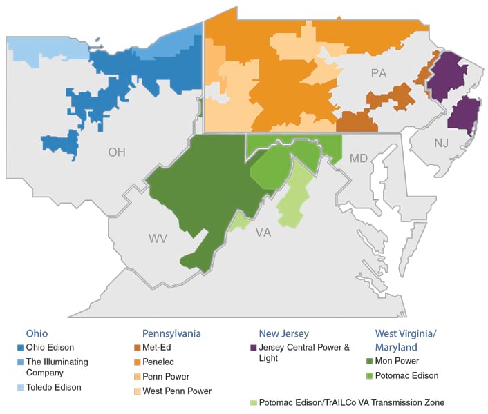
FirstEnergy is one of the largest investor-owned electric systems in the United States, with 10 regulated distribution companies that serve 6 million customers via more than 269,000 miles of electric power distribution lines. As part of an effort to modernize its grid, FirstEnergy recently deployed ArcGIS Utility Network to over 650 end users across all 10 of its operating companies. This makes it one of the largest Utility Network implementations in the United States in terms of the number of users and the number of assets managed by the system.
FirstEnergy implemented Utility Network as part of a larger effort to update and improve its operational technology. The company had a heavily customized legacy mapping system that had exceeded its useful life span. The system was no longer supported by the vendor and lacked the capabilities needed to address modern utility changes. FirstEnergy wanted a solution that would enable it to perform advanced network analytics and supply detailed asset information to Oracle’s Advanced Distribution Management System (ADMS). After evaluating several options, Utility Network stood out as the solution with the best performance, most advanced capabilities, and strongest prospects for future development.
SSP Innovations led the 150-person project team—consisting of staff from FirstEnergy, Esri, and RAMTeCH (another Esri partner)—that carried out the implementation. The team optimized business operations; developed a network model for 2,200 substations and 8,500 circuits; migrated data from FirstEnergy’s legacy GIS; integrated FirstEnergy’s ADMS implementation; and conducted more than 18,000 hours of user training. The team also implemented SSP Productivity, a focused suite of tools that help GIS editors edit data, perform network planning and analysis, and manage work more quickly within Utility Network.
With FirstEnergy’s new system, employees across the utility can share data and collaborate in real time, completing business processes faster and with better insight. Advanced network modeling, data visualization, and analytics are driving improvements in operational efficiency and situational awareness. Moreover, because FirstEnergy made a healthy investment in change management strategies during the project, user enthusiasm for and adoption of the new system were excellent. The project was completed without making any customizations to the core Utility Network product and with minimal adjustments to FirstEnergy’s budget and schedule.
Streamlining Coordination and Collaboration
Waukesha County, Wisconsin, and its 37 municipalities have been building and maintaining a parcel dataset since the early 1990s. Data updates and upkeep fall primarily under the county’s purview.
It was arduous for the county to manage and publish parcel data from multiple entities that have distinct data structures, formats, and naming conventions. This often led to inconsistencies in integrating and maintaining the parcel data. Due to the decentralized nature of parcel data management, sharing and collaboration among different entities was complex and time-consuming—and the lack of standardized processes made it challenging to publish and exchange data efficiently or ensure data accuracy and integrity. What’s more, three cities—Brookfield, New Berlin, and Waukesha—opted to do their own parcel mapping. This caused the periodic publication of the county’s data to be plagued with edge matching and conflation issues and made it difficult for the county to coordinate and foster consistent workflows.
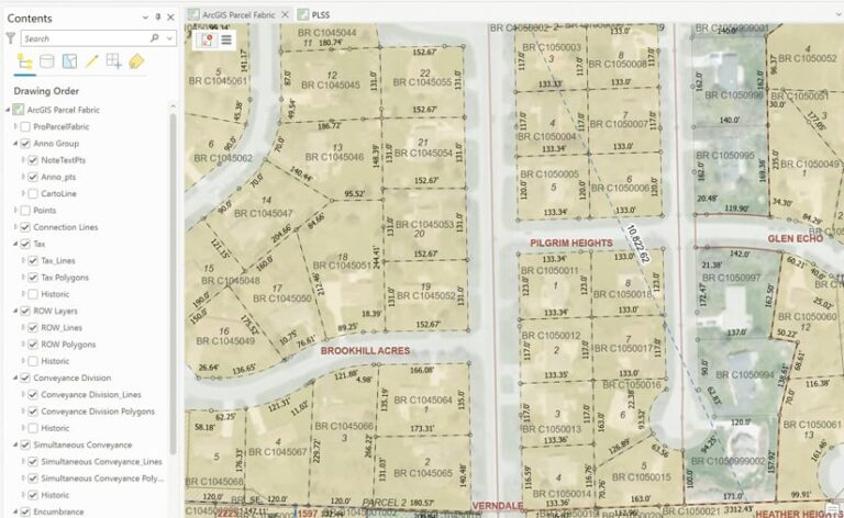
With ArcMap being retired in 2026, staff at Waukesha County recognized that they needed to migrate to a more modern system with greater flexibility and built-in efficiencies. So the county sought assistance from land records specialist Panda Consulting, the first Esri partner to receive the Parcel Management Specialty designation. In addition to helping the county move to ArcGIS Pro and start using ArcGIS Parcel Fabric, Panda assisted with optimizing its parcel data management workflows, identifying areas for improvement, implementing streamlined processes and workflows, and training county staff members so they had the necessary skills to manage parcel data effectively.
These changes ensured greater data accuracy, consistency, and quality; improved collaboration; streamlined workflows; and made staff at both the city and county levels more efficient in maintaining parcel data. Additionally, having all the data stored in ArcGIS Parcel Fabric—the only source for staff members to use to create related web maps and apps—eliminated the need to aggregate the data for publication and sharing purposes.
