Indonesia’s 275 million residents inhabit about 6,000 of the more than 17,500 islands that make up the equatorial archipelago. Almost 97 percent of the population has access to the country’s electrical grid, according to the World Bank. About 87 percent of the grid’s capacity comes from fossil fuels such as oil, natural gas, and coal, while the rest comes from hydropower and geothermal sources. Because of electricity shortages in some rural areas—such as West Kalimantan, a province on the island of Borneo—Indonesia imports electricity from Malaysia as well.
This reliance on fuel-generated electricity is a burden on the country’s financial sector. It also negatively impacts the environment. So SolarBoost—a collaborative project between the university Politeknik Negeri Pontianak in Indonesia and the University of Leicester in the United Kingdom—is seeking to implement solar power plants throughout Indonesia to increase the nation’s grid capacity. The project also includes developing minigrids for small, rural communities.
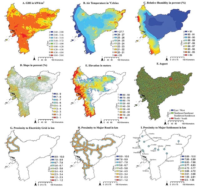
To determine the optimum locations in which to build solar plants—particularly in rural areas—the SolarBoost team has developed a GIS-based system that integrates satellite and regional data for conducting site suitability assessments. In a pilot project carried out in West Kalimantan, whose forests and biodiversity are of global concern, SolarBoost performed geospatial analysis on vast amounts of data to figure out where large-scale solar plants could be developed. Now, government officials and energy developers can use the results of the study to aid in decision-making and accelerate the development of solar energy infrastructure across the region.

Solar Power’s Role in Shifting to Renewable Energy
In addition to expanding the capacity of Indonesia’s electricity production, SolarBoost seeks to help reduce the country’s dependence on fossil fuels. Recently, Indonesia pledged to cut its carbon emissions by at least 31.89 percent by 2030. The country has also set a goal to increase the share of renewable energy in the national energy mix to 23 percent by 2025.
“We believe that solar energy can play a major part in [Indonesia’s] shift to renewable energy,” said Dr. Ibrahim-Bathis Kunhali, a project scientist at the Kerala State Council for Science, Technology, and Environment (KSCSTE) in India and a former research associate for the SolarBoost team.
Given this context, SolarBoost has attracted extensive interest and support from the government of Indonesia. Currently, SolarBoost is working with 11 government agencies and departments that range in scope from rural development to environmental conservation. These groups provide data and status reports on land cover, land use, soils, climatology, infrastructure, and more, which the SolarBoost team stores, analyzes, and processes using ArcGIS technology.
The Spatial Analysis Toolbox Proves Key
Indonesia’s diverse cultural and ecological conservation areas cover about 18 percent of its landmass. To ensure that these critical locations are protected when selecting sites for solar energy facilities, the SolarBoost team had to study and spatially analyze extensive amounts of data. This included solar irradiance and weather condition data derived from satellite imagery, as well as the land usage, topography, population, roadway, conservation area, and electrical grid connection point data provided by government stakeholders.
“The collected data defines the characteristics of an area in terms of its suitability for the development of a solar PV [photovoltaic] power plant,” said Kunhali.
The data is organized into two planning processes that rely on geospatial analysis: demarcating barrier zones, which are protected areas where large-scale solar power plants should not be developed, and identifying feasible zones, where PV plants can—and probably should—be developed.
To conduct these analyses, the team employed what’s called the Analytic Hierarchy Process, a method of organizing and analyzing complex data that helps determine which sites should be prioritized over others. The process included doing a multicriteria decision analysis, which evaluates options that have conflicting criteria.
“The Analytic Hierarchy Process was used [to rank] all [the] data to get a final weighted value according to [each site’s] importance for large-scale solar photovoltaic plant development,” said Kunhali.
All this was done using tools in the Spatial Analysis toolbox in ArcGIS.
“We used [the toolbox] for spatial data creation, data classification, analysis, [and] mapping,” said Kunhali. “Overlay analysis was performed to combine all the [data] layers for an accurate spatial analysis of the best site location for large-scale PV plant development.”
A Successful Project Guides Future Development
The spatial analysis done on West Kalimantan was highly successful. It quantified an area of 18–42 square miles that has the potential to generate an impressive 2.034–4.785 gigawatts of electricity. Most importantly, the location wouldn’t require cutting down forests or overrunning protected areas or Indigenous communities, supporting the country’s requirement to manage and maintain its biodiversity.
“With web-enabled…maps and GIS data layers, we created the first-ever surface solar irradiance analysis that enables the inclusion of solar energy farms within the policy making strategy for energy production in Indonesia,” said Kunhali. “We focused on the [West Kalimantan province] because of the challenges of grid development there due to its remote location and the necessity to protect its natural resources and Indigenous communities. By selecting this area, our study also provides the guidance [to assess] PV plant [sites] for similar…rural areas of the country.”
SolarBoost also demonstrated how critical it is to use GIS for processes like these.
“We used it to perform multiple assessments on the cost of electrical power generation and the benefits that could be derived from the installation of a solar farm [in] West Kalimantan and other Indonesian provinces,” said Kunhali. “ArcGIS also supported the reporting of legal and infrastructure constraints that could affect the timely deployment of PV projects.”

