New York City, like so many other municipalities across the United States, is facing a severe housing crisis. This is leading to high rents, gentrification, segregation, poor housing quality, tenant harassment, homelessness, and other issues that affect a market where residents have scarce housing options.
To help combat housing scarcity, the New York City Department of City Planning (NYC Planning) developed a geospatial survey app to determine whether planned housing projects are eligible for the new citywide Green Fast Track for Housing rule. The rule streamlines housing production by allowing projects that fit specific criteria to access a simplified environmental review process while still satisfying state and city environmental standards.
The app—which integrates ArcGIS Experience Builder with ArcGIS Survey123 and Microsoft Power Automate—enables users to identify tax lots relevant to a proposed housing project and enter project criteria, such as unit count, building height, and distance from sensitive areas. The resultant data can be used to determine whether a project is eligible to be fast-tracked under the new rule.
Among the factors contributing to the high cost of housing in New York City is the lengthy approval process required before construction can begin.
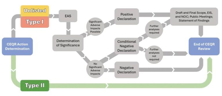
Most housing projects that are subject to land-use approvals or are eligible for public financing must conduct an environmental review that can take as long as two years and cost hundreds of thousands of dollars to complete. Yet, according to an NYC Planning analysis of more than 1,100 projects reviewed from January 2013 to May 2023, modest projects that met certain criteria had no impact on their surrounding environments.
Seeing the opportunity in these results, city agencies adopted a new environmental review rule, referred to as the Green Fast Track for Housing. The rule exempts housing developments up to a certain size that meet certain environmental and location criteria from further environmental review, since analysis has shown that they will not cause environmental impacts. This decreases the overall costs for the projects, increases opportunities for small housing developers, and shortens the time needed to complete the approval process. The goal is faster delivery of new homes to residents who need housing.
To help developers, planners, and city staff evaluate whether projects may be eligible for fast-tracking under this new rule, NYC Planning developed the Fast Tracker app. The goals for the app were as follows:
- Provide a map- and survey-based interface.
- Present data specific to each project, to be used as part of a project application.
- Allow users to independently enter project information to determine eligibility at different stages of the design and approval process.
- Store minimal project data on NYC Planning infrastructure.
- Coordinate the app’s release to coincide with approval of the rule itself.
NYC Planning has a full-stack development team, but choosing commercial off-the-shelf (COTS) technology allowed the agency to satisfy project objectives while sticking to a tight timeline. Esri’s ArcGIS Experience Builder and ArcGIS Survey123, plus Microsoft’s Power Automate, were chosen as the front-end, data entry, and back-end components of the app.
Fast Tracker is divided into a few primary Experience Builder and Survey123 pages, and users are guided by a sidebar containing a list widget with explanatory information.
Initially, users are directed to use the Select widget to choose all tax lots that will be affected by their projects, either directly through construction or through associated zoning actions. Users can find tax lots by inputting their Borough-Block-Lot (BBL) identifiers or addresses or by manually navigating to them on a map. They can then select or deselect tax lots on the map. After choosing the appropriate tax lots, users click Begin Survey and navigate to the survey page, which contains another map.
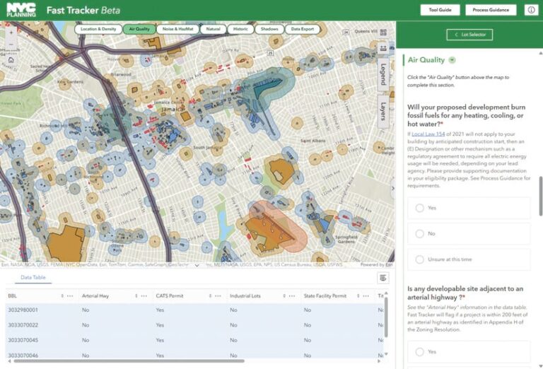
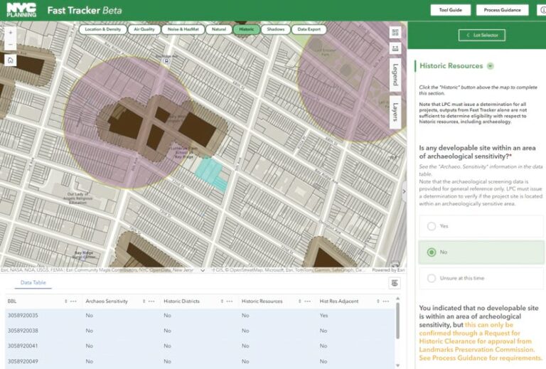
The survey page retains any tax lot selections made on the previous page. The map takes up the majority of the screen, with a table below and an embedded Survey123 form to the right. The survey is broken up into sections—including Air Quality, Noise, Natural Resources, and Shadows—that pertain to the various eligibility criteria under the Green Fast Track rule. Near the top of the app, there are tabs that navigate to different maps related to each survey section. The table below the map displays information about each tax lot relevant to whichever tab is selected.
The sidebar directs users to work through the survey, entering information such as BBLs, building height, and the number of proposed residential units into the survey fields. As they reach the end of each section, they select the next tab on the map, which provides them with the relevant lot information for that map and survey section.
The survey responds dynamically to user input and provides immediate eligibility feedback based on the data that’s entered. For example, if a user indicates that their project will burn fossil fuels for heating, text appears that says this criterion makes their project ineligible for fast-tracking under the new rule. If a user indicates that their project may cast shadows on an open space, they must submit additional information to determine eligibility.
At the end of the survey, users are prompted to export a comma-separated value (CSV) summary of the relevant tax lot information and to generate a PDF report of the survey results. A Power Automate webhook triggers an automation function to generate a PDF report of the survey results and send it to the email address provided in the survey. The automation also performs basic error handling, such as sending an error report if any failures are detected.
The report is a reiteration of the survey combined with any eligibility messages triggered by survey responses. Users can submit the reports as part of their development applications.
To work, the Fast Tracker app requires around 50 datasets, all taken from federal, state, and city sources, as well as organizations such as the Port Authority of New York and New Jersey. The datasets indicate wetlands, historical landmarks, airports, highways, tunnel vents, zoning districts, and more.
Staff from NYC Planning sourced, vetted, and engineered the data and published it to ArcGIS Online for ingestion into the app. They also simplified the datasets to facilitate symbolization within the app and used them to precalculate proximity values for every city tax lot. These datasets are used to populate the maps and attribute tables in the app, as well as the associated CSV exports.
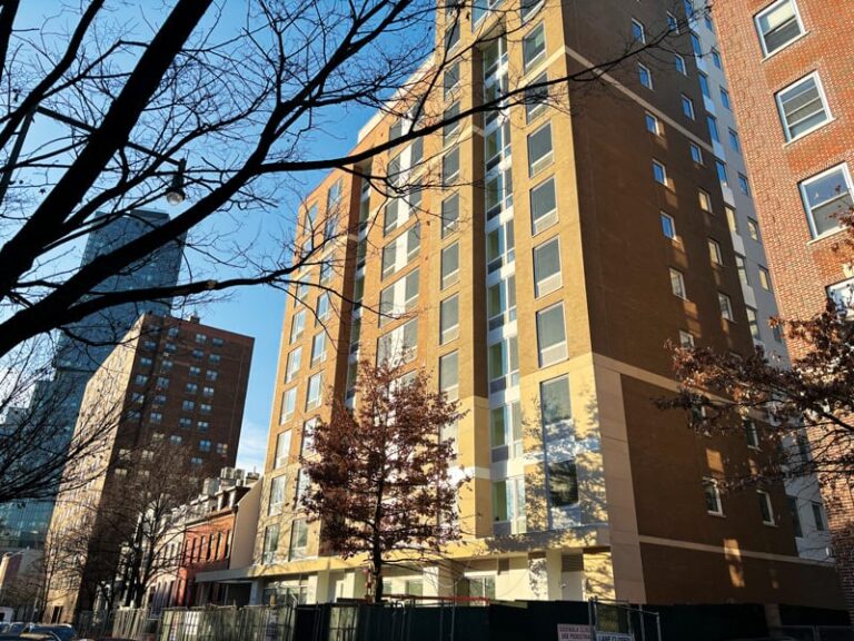
In March 2025, an affordable-housing project for seniors with 53 units, proposed to be built in Brooklyn, entered New York City’s public review process under the Green Fast Track rule. This is the first project to reach this milestone since the rule and app were released in June 2024, and more projects are now under review.
“By implementing Green Fast Track and developing a user-friendly application to determine project eligibility, New York City has significantly streamlined the environmental review process for green housing projects—saving time and money and helping the city achieve its housing and climate goals,” said Dan Garodnick, the director of the New York City Department of City Planning.
Over the last year, the Fast Tracker app has undergone multiple rounds of bug fixes and enhancements, all tracked within a public GitHub repository and change log. Currently, NYC Planning is working on expanding this project to streamline other aspects of the environmental review process. The department is developing a data hub to facilitate environmental assessments and is exploring the potential for dynamically aggregating and calculating population and resource data to simplify assessments.
For more information about the Fast Tracker app, contact the GIS team at NYC Planning at DCPOpenData@planning.nyc.gov.
