With the Technology, International Organizations Can Monitor and Profile Vulnerable Populations to Get Them the Help They Need
Persecution, poverty, conflicts, and natural disasters around the globe lead to the mass displacement of people in many countries. Some cross internationally recognized borders and acquire refugee status. Many others, however, remain in-country and become internally displaced persons, or IDPs.
In recent years, armed conflicts in Iraq, Syria, Yemen, South Sudan, and Bangladesh along with natural disasters in Haiti and Nepal have caused millions of people to flee their homes in search of safety. When the current crisis in the Middle East peaked in 2015, more than 1 million people fled to Europe due to armed conflict in their own countries. The United Nations High Commissioner for Refugees (UNHCR) estimates that there are 65 million people currently displaced—26 percent of whom are in the Middle East and North Africa.
The UN’s International Organization for Migration (IOM) tracks, monitors, and reports on the movement of IDPs and migrants in countries such as Iraq, Yemen, Nigeria, Haiti, Mali, and Afghanistan. To keep track of their locations, conditions, access to services, and humanitarian needs, the organization uses an innovative information system called the Displacement Tracking Matrix (DTM), which has ArcGIS technology as one of the main components.
Devised in 2004 to track IDPs in Iraq, DTM is a crucial visualization tool for IOM. It enables humanitarian workers to better target and prioritize all types of humanitarian assistance—from shelter, water, food security, and sanitation to health, protection, and access to other relief services—by pinpointing locations that have urgent needs.
For all DTM operations, IOM deploys field teams to strategic locations throughout a country to gather information. Barring access constraints, these teams collect data at every location where IDPs are present. Using mobile devices that employ different online platforms, such as Open Data Kit, fieldworkers collect both basic and standardized data and then transfer the data to a central Microsoft SQL Server database. From there, DTM’s GIS team can visualize and analyze the data using ArcGIS Desktop and ArcGIS Online.

A Surge of IDPs
The security situation in Iraq has been precarious for decades. But the emergence of the Islamic State militant group (also known as ISIS or ISIL) in 2013 marked a dramatic deterioration of stability in the country. Heightened armed conflict drove millions of people from their homes.
To deal with the surge of IDPs in Iraq over the last five years, IOM has strengthened its field operations and brought more technical experts on staff to enhance the DTM. Now, IOM has 125 field staff collecting data on how many IDPs and returnees there are across the country and where they are located.
Split up into rapid assessment and response teams, field staff talk to key informants, such as community leaders, local authorities, and security forces, twice a month to get baseline population data for each area, including the number of families living there, their GPS coordinates, and how they’re living—in private homes, camps, religious buildings, hotels, or elsewhere. They also get supplementary data from government registration centers and partner agencies. Currently, IOM has about 9,500 key informants who regularly and systematically provide information for use in the DTM.
Once every three months, IOM’s field staff also assess the locations that host IDPs and returnees. They look for any infrastructural damage, additional ethno-religious data, and information on IDPs’ intentions—whether to return home, stay put, or emigrate to another country—to address issues such as safety, gender-based violence, employment, and education. This not only helps the organization gather more in-depth, multisectoral information on things like where people get their drinking water and food, how they access health care and education resources, and where their livelihoods come from, but it also further validates the numbers given by population data sources. For IOM updates all IDP and returnee records for Iraq monthly.
Where Populations Cluster
GIS is integral to the DTM. It helps improve the quality of the data, is key to analyzing it for operational use, and makes it easier for IOM to share information with its humanitarian partners.
Due to armed conflict, it is not always possible for IOM field staff to view and verify the locations of IDPs and returnees in person. So IOM uses online web mapping apps in a geoportal to let fieldworkers see where IDPs and returnees are situated and correct any erroneous locations.
Accessible via ArcGIS Online, this geoportal is a standards-based, open-source solution that gives organizations an enterprise-level view of the data they record. It allows users to catalog the locations and descriptions of any geospatial resources in a central repository and then publish that information to the Internet or an intranet. Visitors to the geoportal can then search those resources and use them for various projects, such as getting IDPs and returnees immediate aid for survival or planning out longer-term assistance, wherever they’re located.
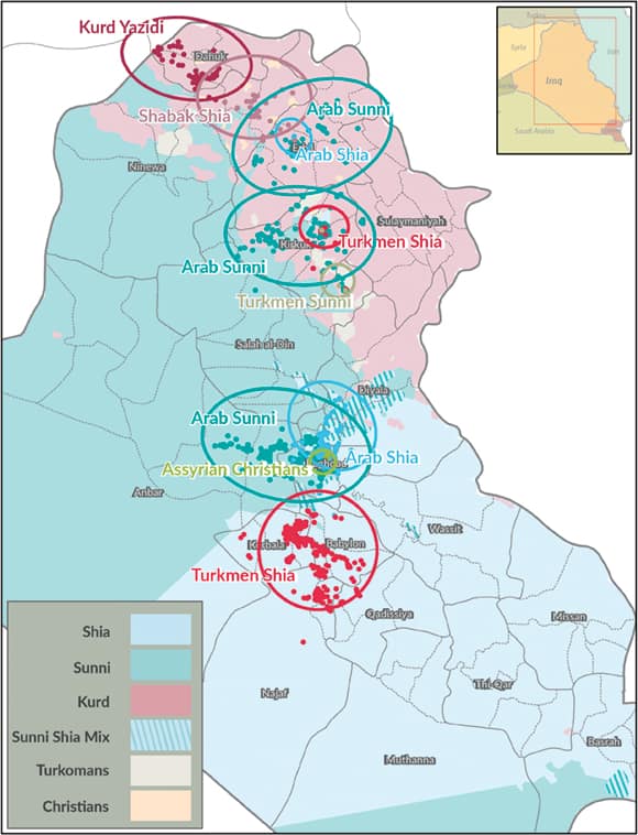
Staff at IOM also use ArcGIS Desktop to perform spatial analysis so they can prioritize and target certain humanitarian response efforts. For example, a spatial analysis of IDPs’ different ethnicities and religions revealed key linkages between these traits and where IDPs choose to settle during their displacements.

In Iraq, the ethnic majority is Arab, and Shia Muslims constitute the dominant religion. Shia Arabs predominantly live in the central and southern parts of Iraq. Arab Sunni Muslims make up the second largest ethno-religious group, and they generally live in central and western Iraq. The country’s north and northwestern regions are more diverse. Various ethno-religious groups live there, including Kurds (mostly Sunni and Yazidis); Turkomans (mostly Shia); and minority ethnic groups such as Chaldean, Assyrian, and Armenian (all Christians), as well as Shabak (mostly Shia).
To conduct this spatial analysis, IOM field staff had to first collect the necessary ethno-religious data all across the country. Once they had that, the GIS team used the Hot Spot Analysis tool in ArcGIS Desktop to calculate where features with high or low values are spatially clustered.
With this, IOM could clearly see that Arab and Turkmen Shias cluster in Shia-dominated areas in the north and south, while Sunnis, such as Arab Sunnis and Turkmen Sunnis, form hot spots in Kurdish and Arab Sunni areas. The largest Kurdish group, Kurd Yazidis, form a cluster in the Kurdish region itself, as do almost all Shabak Shia IDPs, who are ethnically Kurdish.
This analysis suggests that religion and ethnicity play a major role in the decision-making process when IDPs are figuring out where to go after being forced from their homes. It also reveals that a larger variety of ethno-religious IDP groups prefer Kurdish areas over other parts of the country, while Arab Sunni clusters are conspicuously absent in Arab Shia areas and vice versa.
A Spatial Decision-Making Support System
The geoportal server also allows IOM to rapidly share critical information with partner organizations. In Iraq, this has made the overall humanitarian response mission more efficient and effective.
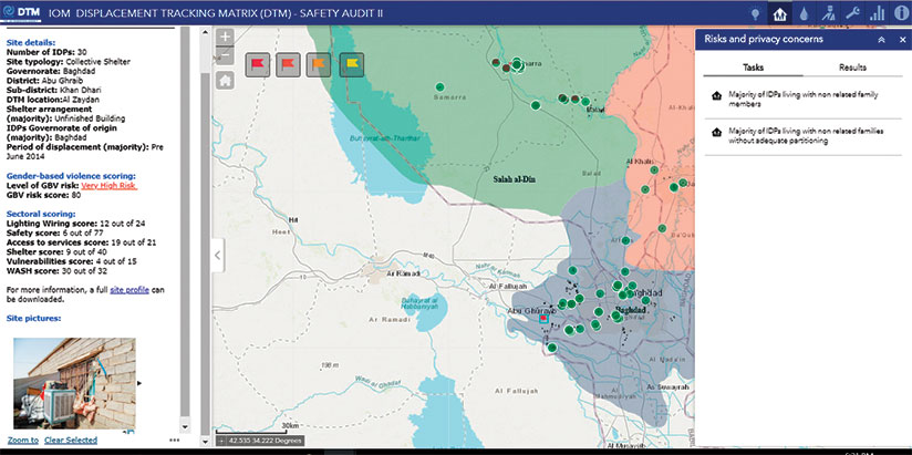
For instance, IOM did a safety audit that evaluated the risk of gender-based violence in certain locations based on infrastructure, security, women’s participation in education and seeking gainful employment, and the availability of protection services. The GIS team used ArcGIS Desktop to highlight locations with reported safety issues alongside additional geographic information, such as road connectivity and district and state boundaries. Each area was further broken down into multisectoral indicators, including the number of people without jobs or basic needs like food and water. The team then used ArcGIS Online to present this data in a dashboard-like format—complete with site profiles and photos—and made it available for download on the DTM.
With the ability to visualize this data online via a dashboard, IOM and its partners essentially turned the portal into a spatial decision-making support system. It allows the organizations to zero in on the informal sites reporting the highest vulnerability scores and swiftly target risky areas.
Strengthening Future Humanitarian Responses
With armed conflict happening in so many places throughout the world and climate change affecting various populations, millions more people will likely be displaced in the future. The DTM, which IOM uses all over the globe, is becoming more established as an information management system that provides up-to-date data during ongoing crises and in emergency situations.
IOM continues to refine its data collection and analysis methodologies, adjusting them to new humanitarian needs and changing human mobility patterns. This will ensure that the DTM persists in providing innovative technical solutions to help people understand displacement and aid organizations in planning and implementing humanitarian responses.
For more information, email GIS officer Riju Stephen at rstephen@iom.int, information management officer Claudia Pereira at cpereira@iom.int, or regional data hub coordinator Laura Nistri at lnistri@iom.int.

