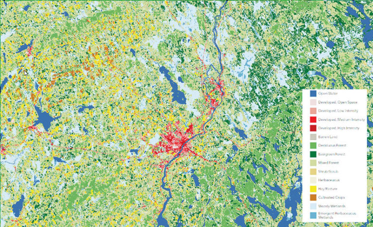
What do you get when you combine big data, satellite imagery, and AI? There are lots of answers to this question—and one of them is the ever-expanding collection of high-quality land-cover models available in ArcGIS Living Atlas of the World.
The land-cover maps generated by these models can be used for environmental monitoring, resource management, urban planning, and more. ArcGIS Living Atlas users don’t need extensive training, computational resources, or AI expertise to employ these models. And they can produce high-quality land-cover maps that classify building footprints, evaluate damage, and determine an otherwise bewildering array of land-cover types in a variety of spatial resolutions and revisit periods.

A Range of Resolutions
The Land Cover Classification (Landsat 8) model is an important lower-resolution resource for producing land-cover maps. Based on Landsat 8 imagery at 30-meter resolution, such maps are ideal for conducting long-term analysis on land-cover change to study things like climate change and help manage resources such as forests, water bodies, and agricultural areas. The maps can be used to quantify changes in carbon storage, surface-light reflection, and land-surface temperatures.
For medium-resolution imagery, the Land Cover Classification (Sentinel-2) model provides 10-meter resolution. Images created with this model are useful for environmental monitoring such as tracking vegetation, examining water bodies, detecting hazards for disaster management, and aiding land-use planning by offering insight into land-cover changes and urban expansion.
Several models, including High Resolution Land Cover Classification – USA and Land Cover Classification (Aerial Imagery), are tailored for high-resolution data. These models can be used to create maps for monitoring crop types and health, planning infrastructure, identifying tree species, assessing vegetation conditions, and monitoring natural resources.
Choosing the most suitable satellite imagery sources and pretrained deep-learning models can help align specific land-cover mapping apps with an organization’s requirements. In this way, land-cover maps, complemented by additional data layers available in ArcGIS Living Atlas, can provide a holistic picture of human and natural footprints across the planet.

Recent Additions to the Collection
One of the models recently added to ArcGIS Living Atlas is called Text SAM. Created in February, Text SAM is an open-source sample model that enables users to employ free-form text prompts to get the model to indicate surface features such as automobiles, swimming pools, ships, airplanes, and solar panels.
Another new pretrained model in ArcGIS Living Atlas, created in January, can be used to classify crops via multispectral satellite imagery. Called Prithvi – Crop Classification, it was developed by IBM and the National Aeronautics and Space Administration (NASA) to assist with tasks such as crop monitoring and water irrigation management.
Next Steps
Discover these and other pretrained deep learning models in ArcGIS Living Atlas of the World. Then learn how to use them in ArcGIS.
To ask questions or gain more insight into what these models do—or to contribute ideas for additional AI-powered feature extraction tasks—join the conversation on Esri Community.

