Los Angeles is an incubator for new ideas. It’s where the film industry got its start, the fitness craze took shape, and the modern food truck movement hit the road.
Now, the City of Los Angeles and Esri have partnered on a project that will spur even more innovation in government, business, and other organizations: GeoHub.
Unveiled recently by Los Angeles mayor Eric Garcetti, GeoHub gives city staff, businesses, app developers, nonprofit organizations, and the public access to the city’s location-based data through an online portal. People can download datasets as shapefiles, KML files, or into spreadsheets. They can also visualize the data as online maps using ArcGIS. GeoHub combines the city’s geographic data into a location-as-a-service (LaaS) platform, allowing users to access live, continuously updated data directly from the city as a service—rather than as a static download—and create dynamic applications on the fly.
Los Angeles GeoHub is the centerpiece of Garcetti’s effort to make the Southern California city a world leader in open data and civic innovation. As it rides a wave of transition—with startups launching, the arts thriving, and Angelenos bubbling with ideas—the city is also poised to transform the way people, businesses, and government interact.

By opening Los Angeles’ data to everyone, Garcetti hopes to make city operations more efficient, stimulate partnerships between the city and the community, and give residents a greater controlling stake in government.
“Los Angeles is known as a place that thinks big. We are known for our curiosity. We are known for our innovation,” said Garcetti at the GeoHub launch on January 29 at the city’s La Kretz Innovation Campus.
“[GeoHub] will help us reinvent the way that we deliver services and broaden our ability to engage residents and businesses to improve the quality of life in their city.”
Free-Range Data
Like many municipalities, Los Angeles’ city departments use GIS to manage resources and make better decisions.
While GIS is an invaluable tool for achieving the city’s missions, the data and services within each department are not always readily shareable. GeoHub aims to make each department’s data available online in real time (or near real time) to boost efficiency and eliminate the information bottleneck. By connecting Los Angeles’ datasets across departments, the city will be better equipped to deal with issues such as public safety and homelessness.
“Imagine if police officers, firefighters, emergency workers, and first responders all had access to the city’s data for every specific place at any time, anywhere,” said Garcetti. “Public safety personnel could make critical, real-time decisions based on solid, map-based data. And GeoHub makes that possible.”
He detailed how firefighters would be able to use the portal: “Let’s say a firefighter with an iPad or a mobile device is called to respond to an emergency like an earthquake. Well, thanks to GeoHub, he or she could just pull up more than the 911 data for that call. They could find important facts, like building inspection status, location of the nearest fire hydrants, sewer lines, streetlights—any information that would make it easier to respond to an emergency.”
Fewer Stovepipes, More Networks
The story of the firefighter accessing current GIS services represents a paradigm shift in how cities operate. At the GeoHub launch, Esri president Jack Dangermond illustrated how the government of Los Angeles could better serve its people by abandoning hierarchical decision making in favor of a network-based approach through GeoHub.
“I can search for maps, I can mash up [or] combine maps, I can get insights, I can make better decisions,” Dangermond said. “[GeoHub] flattens out a shared infrastructure of content.”
In other words, a network-based model, where information and feedback can be freely shared among stakeholders (including the public), leads to democratic policy making that is better for the community overall.
The World’s Largest Tech Incubator
Mayor Garcetti’s vision of an open data platform for the City of Los Angeles goes beyond serving the government. GeoHub aims to create partnerships between the city, academia, nongovernmental organizations, businesses, and startups.
For Los Angeles, startups represent not only potential economic development but also collaboration opportunities for solving some of the city’s biggest problems.
One such partnership is actually La Kretz Innovation Campus, where the GeoHub launch took place. Located in the heart of Los Angeles’ flourishing Arts District, La Kretz is a clean technology, or “cleantech,” incubator owned by the Los Angeles Department of Water and Power, where startups, scientists, engineers, and policy makers can develop energy solutions that support Los Angeles’ green economy.
GeoHub provides a similar opportunity for startups interested in solving issues such as reducing traffic or greenhouse gas emissions—and anything else that is spatially related. Developers can access the city’s data, along with open APIs, to build apps that they can bring to market.

“What I’ve said to tech leaders is, ‘Use LA as a platform; this is the best platform anywhere in the world,'” said Garcetti. “We are open for business.”
Apps Provide Government Transparency
Open data may be old hat to GIS professionals or data scientists, but for others, the concept may be relatively new. If that is the case, GeoHub provides a simple and intuitive user experience for searching and mapping the data, with categories that include infrastructure, safety, business, transportation, and recreation and parks.
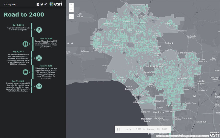
GeoHub features web mapping apps that are designed to provide transparency and empower people to take part in their government. Street Wize, for example, allows Angelenos to track current and upcoming permit and construction activity around the city so they can plan accordingly to avoid delays. Vision Zero uses a data-driven approach to reduce traffic-related injuries and deaths—with the goal of eliminating them altogether by 2025. And Road to 2400 shows the 2,400 lane miles of streets that Los Angeles was able to pave on a 2,200-lane budget.
Next Time You Think Los Angeles, Think Open
GeoHub marks the beginning of a new era of open data innovation in government. By compiling the city’s disparate datasets into a single LaaS platform, Los Angeles is breaking down the barriers that cause inefficiency and is working toward becoming a smarter, safer city. With data available by way of intuitive apps, residents can play a greater role in shaping their government. And by providing opportunities for startups, Los Angeles can continue to ride its wave of high-tech innovation.