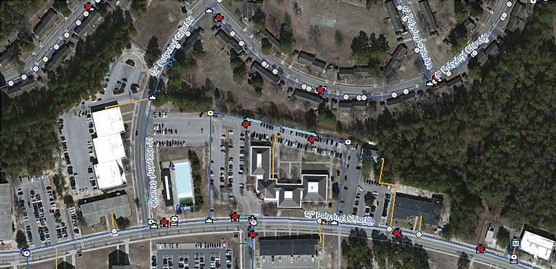
When US military bases started outsourcing their water and wastewater utilities to the private sector, American States Utility Services (ASUS), a subsidiary of American States Water, began building a business that now services eight installations from Maryland to Texas.
To provide excellent service to the military personnel who live and work on each base, ASUS aims to increase both client satisfaction and operating efficiency. This requires having an accurate inventory of utility assets on each base.

With help from Esri partners Timmons Group and Cityworks, ASUS implemented the ArcGIS Data Reviewer extension—alongside other mainstays of the ArcGIS platform, such as Collector for ArcGIS—to improve and ensure operational integrity and efficiency in the utilities it manages for the US military.
Incongruous Data
When the US Department of Defense (DoD) puts a military base’s utility system up for bid, it issues a 50-year contract to the successful bidder and turns over responsibility for the base’s utility operations, management, and capital improvements. These awards are based on a master asset inventory that the military maintains. At times, however, these records can be out of date—as Amanda Owens, operations support manager for ASUS, realized when she was going through the data her company inherited from the military.
“Our data was not congruent,” she said. “The information was just not there. And when GIS data was available, it had a lot of floating assets and [lots] of assets going in the wrong direction.”
Getting the data wrong could have had a significant impact on the inventory and, ultimately, the ability to provide first-rate service to the client.
To get a more accurate view of the assets that ASUS owns and maintains, the company contracted with Timmons to implement the asset management solution from Cityworks.
“In a matter of a year, with essentially three or four GIS technicians, we have managed to update eight major geodatabases and roll Cityworks out at the same time,” said Owens, praising Timmons for its support.
Data Validation
But the GIS implementation did not stop there. ASUS also hired Timmons to train its GIS staff on using ArcGIS Data Reviewer, an extension from Esri that provides quality control and assurance. In no time, they were implementing data validation on their own.
Helen Johnson, a GIS technician at Old North Utility Services, the ASUS subsidiary operating at Fort Bragg in North Carolina, said Data Reviewer turned out to be “exactly the tool I hoped it would be.”
She uses it extensively to find anomalies in her utility data, such as duplicate assets, mains and laterals that cross (even though they shouldn’t be connected), and pipes that don’t terminate where they should.
“When you look at it, you say, it’s only a foot or two here and a foot there. But when you’ve got 20,000-plus segments of water mains and laterals, it adds up,” said Johnson. “Finding those little inconsistencies and being able to fix them in the long run means a more accurate inventory and a better relationship [with] the government.”
Asset Replacement Records
Old North also uses GIS to keep track of asset replacements.
One of the stipulations of the DoD contract is that the civilian operators have to replace all utility assets—every valve, pump, and pipe—at least once during the life of the contract.
At Fort Bragg, every time Old North replaces a piece of pipe, it records and tracks that activity and retires the old pipe to indicate its compliance with the contract requirements. Until recently, the company documented these activities in the spreadsheet it inherited from the military. But now, the company handles it using ArcGIS for Desktop.
“We know we need to replace all this within 50 years,” said Owens. “But we want to do so in a manner that has the most beneficial impact on our customer. That way, the government is getting the most value for its buck.”
Better Serving Customers
Most encouraging to Owens and Johnson is the impact their efforts have had on their customers: military personnel stationed at the bases.
“In the municipal world, the average person walks up to their faucet every day and has no idea where the water comes from or how it got there,” said Owens. “They just want it to be clean and to be able to use it. That’s the same thing we’re doing here for our military.”
Before ASUS took over Old North, the utility averaged 500,000 to 750,000 gallons of sewage overflow each year. In recent years, however, Old North has averaged three or fewer overflows with a loss of less than 1,000 gallons per year, according to Owens.
Using GIS “certainly has improved operations for them,” she said.
Distinguished Service
Implementing GIS—particularly the ArcGIS Data Reviewer extension—verifies that ASUS is spending DoD funding prudently. It also ensures ASUS customers—the men and women serving in the United States military—the highest-quality customer service, complete with responsive and capable operations support.
For more information, email Amanda Owens. To learn more about Timmons Group, email Courtney Moore. And for more information about ArcGIS Data Reviewer, email Dewey Marino.

