A Passion for GIS and Feeding the Poor
Nadika Senadheera’s job as a GIS consultant takes her to places where death may be only a doorstep or two away.

That became a tragic reality in May 2013 when she was on assignment in Kabul, Afghanistan, for her employer, United Nations’ World Food Programme (WFP). One of her good friends, a woman from Italy who worked for the International Organization for Migration (IOM), suffered severe burns when suicide bombers set off an explosion outside a compound that housed IOM in Kabul.
During that attack, Senadheera hid in a bunker nearby as Taliban attackers detonated bombs, lobbed grenades, and fired at Afghani police and NATO forces.
“Even one of our guesthouses was completely gone. Bullet holes were everywhere,” Senadheera said during an interview at the 2013 Esri International User Conference (Esri UC), almost six weeks after her 14-month assignment in Afghanistan ended.
Though she got out unscathed, the experience was frightening and heartbreaking. “Our good friend, we lost her because the Taliban attacked. She didn’t survive,” said Senadheera, pausing to wipe away tears. “She was 80 percent burned. I apparently had the last picture of her. We had a sushi night in one of our guesthouses, and she came over. I had to share that picture with her parents.”
Danger comes with the territory for aid workers, even GIS professionals like Senadheera who was in Kabul to help organize and manage WFP’s geographic information system and infrastructure and train its staff to use GIS. Though they often work indoors on computers, standardizing and analyzing data or training colleagues how to use geospatial technology, they are sometimes called upon to work in the field in less than hospitable conditions. Even inside compounds protected by security details, there’s no such thing as absolute security.
Though she resisted the idea for a long time, Senadheera finally agreed in 2012 to work in Afghanistan to help the Vulnerability Analysis and Mapping (VAM) analysts properly organize spatial data for WFP (such as the location of helipads and airfields for the aircraft delivering food) and transfer the data into a working geodatabase. GIS will help WFP identify the neediest people there and safely deliver the food.
One night in May 2012, Senadheera huddled in a guesthouse in Kabul for more than six hours, listening to gunfire and bombing outside. “Eight suicide bombers were there shooting and blowing themselves up. I was so scared, and I was under the bed wondering, when would this be over?”
For her GIS work for WFP under such dangerous conditions, Esri president Jack Dangermond called Senadheera a “real hero” and presented her with a Making a Difference Award at the 2013 Esri UC.

Senadheera, who grew up in Sri Lanka, accepts the risks inherent in her assignments for WFP, a nongovernmental organization where she has worked for the better part of the last 13 years. There’s passion in her voice when she talks about the value geospatial technology brings to the mission of feeding people mired in poverty or displaced by a natural disaster or a conflict.
How the World Food Programme Uses GIS
WFP uses GIS in several ways, including for food security analysis—identifying who does not have access to enough nutritious food and the underlying causes of hunger in a region. The organization’s VAM unit does this work.
Part of Senadheera’s job involves training WFP’s national staff to use GIS. She also helps to standardize available spatial data and analyzes and maps the information using Esri ArcGIS. The mapping technology helps WFP identify who needs food assistance (such as malnourished children or disaster victims), where they live, how to safely route the food to the people, and what areas of the country are vulnerable to natural disasters or conflicts. WFP often steps in to help during a crisis and needs to know, quickly, what areas will likely be the hardest hit.
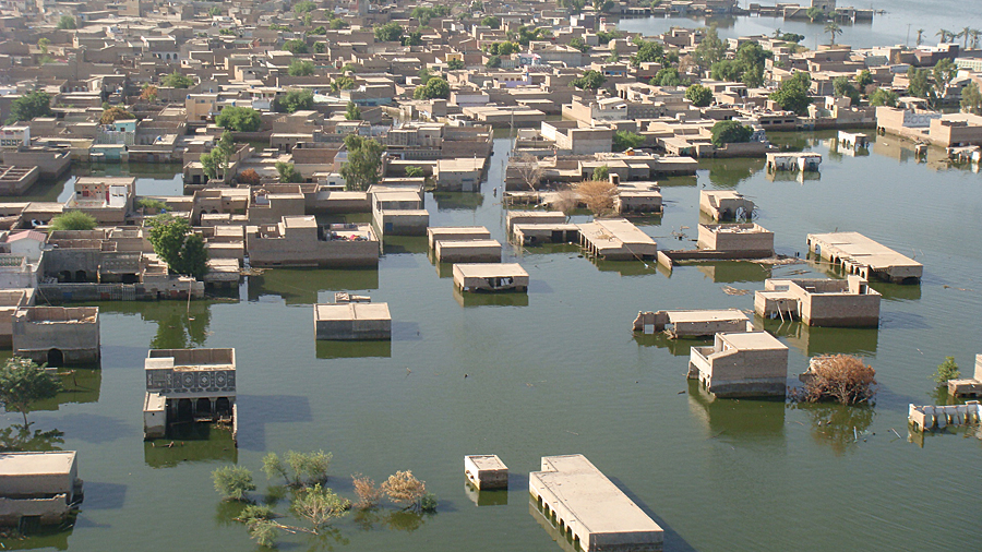
When floods ravaged Pakistan in 2010, Senadheera flew in a United Nations Humanitarian Air Service helicopter piloted by Russians, hovering low over hard-hit Sindh province to drop food to hungry people.
While the crew dispensed the biscuits, Senadheera used a GPS to get the exact locations of where the food was dropped and marked those locations on a basemap. She also kept track of how many cases of biscuits were left at a given location and took an estimated head count of how many people picked up the food. By figuring in the average family size for each person who carried away a box of biscuits and village population data, she could calculate whether the helicopter needed to return to that area and drop off more food. She also used ArcGIS to create maps that showed where WFP had distributed food and where the helicopters still needed to go to distribute more biscuits.
Like Father, Like Daughter
Senadheera said her father instilled a love of maps and travel in her when she was only five. Hema Senadheera served as a radio officer aboard cargo ships from 1975 to 1995, and the stories he told during his brief trips back home were the stuff of legend for the young girl.
“Whenever he came home, he took the globe and he started [to show us] his route—’I went to this country, I boarded the ship, and this is the route I took and these are the people that I met, and these are the countries that I passed’,” she recalled. “And he was showing us his passport and the coins, which fascinated me most.”
A seed was planted. “I thought, this is something cool! Why can’t I follow in my Daddy’s footsteps?”
She started to draw and color maps. Then she studied history of the countries on the maps. By the time she headed off to college, Senadheera knew geography was for her.
She graduated with a bachelor’s degree in geography from the University of Colombo in Sri Lanka in 1995 and soon went to work for the Esri distributor in Sri Lanka. After working briefly for the Asian Development Bank, she received a 15-day contract with WFP in 2000 to analyze World Health Organization data and map where malnourished people, especially children, were living in Sri Lanka. She used Esri software to analyze the data and create the maps, which helped WFP deliver food to the neediest people in the country.
Senadheera received a Fulbright Scholarship to attend State University of New York (SUNY), Albany, from 2004 to 2006. She earned her master’s degree in geography and spatial sciences from SUNY. She later interned at Esri in Redlands, California, before returning to the WFP and her life on the road.
Though her 14 months in Afghanistan were marked by violence, Senadheera feels a sense of accomplishment, having led the effort to build WFP’s geospatial enterprise system for the country and trained close to 120 people—all men—in how to use GIS.
For more information, contact Nadika Senadheera, GIS officer, WFP Country Office.
Related Podcast
GIS in the Fight Against Hunger
GIS consultant Nadika Senadheera talks about her interesting and sometimes harrowing assignments working for the United Nations’ World Food Programme.