The United States Agency for International Development (USAID), formed in 1961, administers international aid and promotes social and economic development on behalf of the US government in countries all over the world. For years, the agency has worked in Nepal through the USAID/Nepal Field Mission. The purpose of this field mission is to design and execute development programs in sectors prioritized by the government of Nepal. These sectors include emergency response, economic growth, health, democracy and governance, education, agriculture, the environment, and disaster risk mitigation.
Given the hundreds of activities in various locations that USAID/Nepal supports, leaders have instituted a geographic approach to implementing, monitoring, and analyzing the outcomes of projects. It is a participatory mapping system, and—because of how easy the technology is to deploy and customize—it relies heavily on ArcGIS Online.

Geospatial Technology Guides Development Activities
In countries where USAID operates, the agency creates development programs based on a Country Development Cooperation Strategy (CDCS). The CDCS—which is prepared using a rigorous analytical process that aligns US resources with the host country’s priorities—outlines goals and objectives that the host country aims to achieve over a five-year period.
“USAID/Nepal is one of the first field missions to adapt geospatial technology to its CDCS development cycle,” said Indra Sharan KC, senior GIS adviser and geospatial analyst at USAID/Nepal.
The field mission has been using Esri technology since 2001 to better target humanitarian and development assistance via geospatial analysis, data visualization, and enhanced communication. It started by providing geospatial services to the entire USAID program in Nepal, which includes partners that oversee specific projects. Now, however, GIS at USAID/Nepal is a decentralized, participatory system that revolves around activity mapping—a standardized way of geospatially tracking all that goes into implementing USAID projects in the country, from strategic objectives to detailed results.
This is all part of USAID’s Collaborating, Learning, and Adapting (CLA) framework, the central approach for how USAID works with partners and stakeholders in host countries on common development issues. The idea is to collaborate and learn from one another’s shared knowledge and then use those lessons to improve development outcomes. Because all USAID/Nepal’s projects are tailored to specific locations, it is a strategy that makes geospatial data an essential part of the decision-making process.
Connected Through ArcGIS Online
USAID’s field mission in Nepal is a data-driven organization that employs geospatially referenced, multisectoral data from various organizations both within and outside the country. Data includes climate and weather information, poverty and income statistics, health and nutrition indicators, population and sociodemographic characteristics, topography and terrain, land-use and land-cover changes detected by remotely sensed imagery, human settlement and migration dynamics, conservation and development information, and economic activity indicators. The data also, of course, includes the locations of all the development activities that partners of the USAID/Nepal Field Mission are carrying out.

“We have an ongoing need for high-quality, disaggregated data that’s collected rapidly, frequently, and accurately,” said Sharan. And the technology that the field mission uses to gather and analyze this data needs to be “developed with limited human resources because we have a small staff,” he continued. “So we standardized on the ArcGIS system because it requires minimum customization, allowing us to focus more on program goals.”
The field mission and its implementation partners have worked with ArcMap and now use ArcGIS Pro. But ArcGIS Online is the backbone of the system.
“We are connected through our ArcGIS Online organizational account,” said Sharan. “Partners using ArcGIS Online can replicate the common standards, data models, and apps and share the hosted feature services and geographic data that we provide.”
USAID/Nepal staff and partners also use ArcGIS Survey123 and other mobile data collection apps built with ArcGIS technology to gather data on project infrastructure. In emergency situations, such as after an earthquake, this data collection often happens in near real time. Additionally, to store important datasets, staff and partners have access to ArcGIS Enterprise on Amazon Web Services via the USAID GeoCenter, which provides geospatial support to USAID programs throughout the world.
A Gold Mine of Insight for Decision-Making
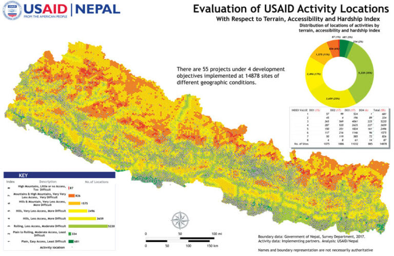
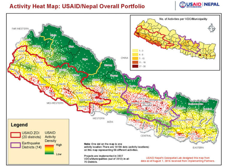
The USAID/Nepal Field Mission works with more than 50 partners that conduct hundreds of activities at thousands of locations, according to Sharan.
“Documenting these locations with related project or intervention information is at the core of USAID/Nepal’s work,” he said. “Knowing and managing this data for the entire USAID/Nepal portfolio reveals a gold mine of insight for decision-making.”
To keep track of all the USAID projects being implemented around Nepal, Sharan and his team developed activity mapping as part of the workflow process. This allows staff and partners to record information about their projects geographically, using a standard spatial referencing framework in ArcGIS.
“Maintaining all the related attributes for these activities using a standard activity data model—from the field data collected to strategic objectives—is the activity mapping workflow,” Sharan explained.
Users at USAID/Nepal employ the Activity Data Organization Tool to input data about their activities into a geodatabase. Based on the level of detail and information required at various times over the course of a project, one of three data models is applied: macro, hybrid, or micro.
The Activity Mapping Tool allows users to crowdsource and map macro data, which tracks strategic USAID project information at the national and regional levels. Users employ the same tool to crowdsource and map project information in a hybrid format that shows data about USAID/Nepal projects at a relatively more detailed scale. Finally, the Intervention Mapping Tool is used to capture disaggregated, micro-level data on projects and their results.

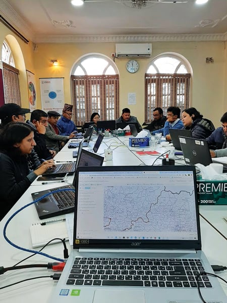
“USAID/Nepal staff held several half-day sessions with the partners to teach them how to use the system to map and document activity locations,” said Sharan.
After experimenting with these methods for years, all USAID/Nepal implementing partners have been using the ArcGIS technology-based system to map their activities since January 2019.
Plans to Expand the System
Conducting participatory mapping on a standardized system using ArcGIS technology has been very valuable to the USAID/Nepal Field Mission. It provides timely, high-quality data; eliminates duplication; and improves overall operational efficiency.
“The activity maps have been strong tools in humanitarian assistance, geographic evaluation and targeting, adaptive management, policy analysis and strategic planning, and results-based management,” said Sharan. “The 3D capabilities of the ArcGIS system create realistic geographic context and visualizations of the intervention sites throughout the country. The visualizations are provided to decision-makers, including the USAID/Nepal program managers located in Kathmandu. This helps them better understand the activities at the sites for subsequent projects and reporting.”
Sharan and his team are currently exploring using ArcGIS Hub to develop an open data site that they can use to share data with citizens and partners.
“Our system is now being scaled up to provide access for development partners and local governments throughout the country with whom USAID operations interact,” said Sharan. “It will be as a monitoring and mapping platform for enhanced coordination and better development outcomes.”
He hopes that USAID/Nepal’s work in GIS can serve as a model for other USAID missions all over the world.

