To help care for and protect natural resources, including land, water, and wildlife, Esri partner Skytec employs unmanned aerial systems (UAS), remote sensing, and GIS technology. In 2019, around the same time the small startup graduated from the Esri Startup program, Skytec developed Ranger, an app for detecting whether high-priority areas are undergoing significant change, such as shrinking or disappearing.

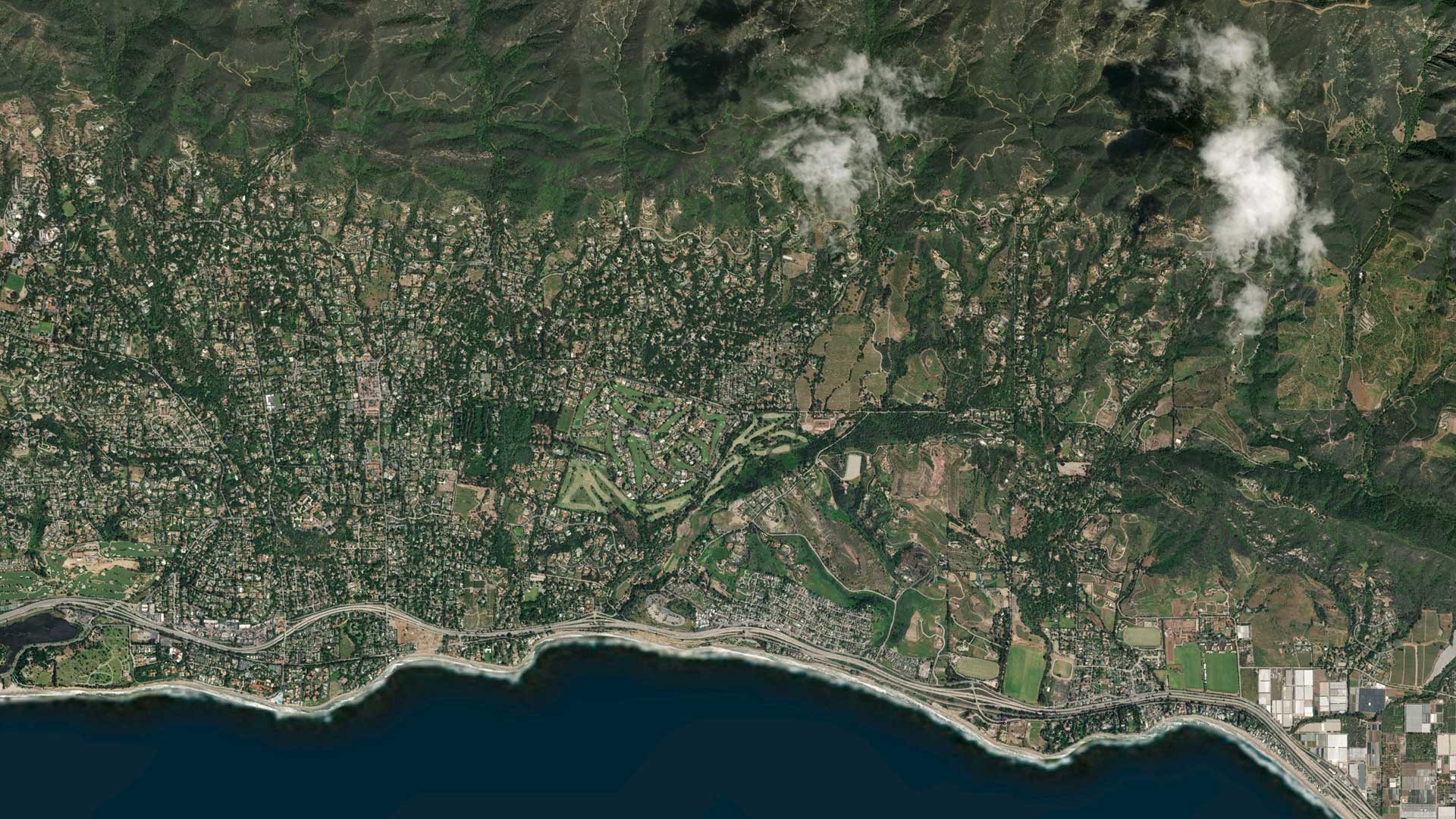
Skytec uses drones and near-daily satellite imagery from Esri partner Planet Labs to remotely monitor subscribers’ property. Clients include land trusts that maintain natural resources, organizations that work in forest agriculture, and pulp and paper industries. The Ranger app, built with ArcGIS Web AppBuilder, is optimized for use on desktop computers and tablets and is already monitoring more than 500,000 acres of land across the United States.
“As we become more wired [and] more connected—[and with] more people on the planet—things are changing fast,” said Andy Carroll, chief technology officer at Skytec. “Rather than being reactive all the time, we can catch things early.”
To better manage and store imagery, Skytec wanted a new, cloud-based solution that was simple to deploy and could scale to meet clients’ growing needs. So the small team of environmental scientists began using ArcGIS Image for ArcGIS Online, a software as a service (SaaS) product that has helped Skytec improve its change detection analysis, provide custom client deliverables, and streamline processes.
Improving Complex Imagery Management Processes
Prior to implementing ArcGIS Image Online, managing and analyzing imagery was cumbersome for Skytec team members. First, they used ArcGIS Pro to mosaic the individual tiles downloaded from Planet Labs’ satellites. Then, they created a tile package from the imagery and uploaded it to make a tiled service.

Processing imagery required a lot of resources as well. After satellite imagery was collected to perform change detection, the team primarily used a desktop computer to produce different types of models, indexes, and scripts. Skytec didn’t have an enterprise server or cloud resources available to help with storage and processing, so the team needed a solution that could better manage assets—and could scale to allow the company to bring products to market quickly.
While Skytec initially wanted a full ArcGIS Enterprise deployment—and is still working to make that happen—ArcGIS Image Online allows the team to host, analyze, and stream imagery and raster collections in the cloud and power the Ranger app in ArcGIS Online. According to Carroll, ArcGIS Image Online was a good solution for Skytec because it could handle the volume that subscribers needed right out of the gate.
To get started using ArcGIS Image Online, Skytec team members tested their raster data in the SaaS offering over several weeks. They leveraged on-the-fly image processing algorithms, also known as raster functions, to create custom raster chains to visualize change. This enabled data analysts to serve out meaningful representations of change over any given area at any given time—which is what Skytec clients are looking for.
Imagery That’s Ready to Visualize and Analyze
Within five or six weeks of deciding to implement ArcGIS Image Online, it was running live at Skytec.
Customers have the option to have their land monitored monthly, quarterly, or at custom intervals. The new method for managing and processing the imagery involves receiving image quads from Planet Labs as tiled GeoTIFFs. These multispectral images are then uploaded as imagery layers to ArcGIS Online for visualization and analysis.
The upload process enables Skytec to automatically create a single tiled imagery layer that’s ready for clients to visualize and the Skytec team to analyze. Users can go into the Ranger app, zoom in on the imagery layer, and see current or previous images throughout the lifetime of their subscription.
-

The team at Skytec uses change detection visualization models, now hosted in ArcGIS Image for ArcGIS Online, to track changes made to conservation easements.
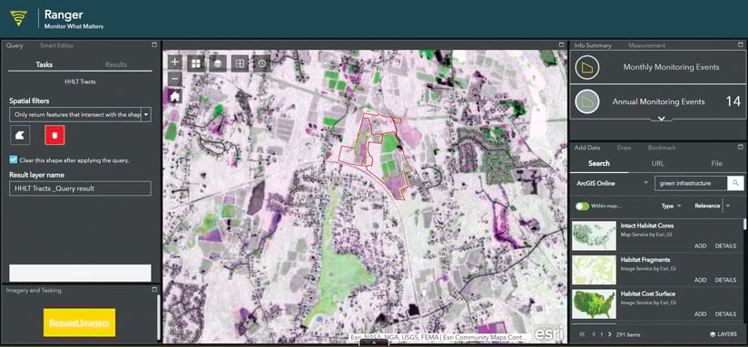
Skytec creates and serves out both tiled and dynamic imagery layers. Tiled imagery layers are fast to create, while dynamic imagery layers enable on-the-fly processing using multiple processing templates, all within the Ranger app.
“It’s neat that a single layer can be used in production and to generate derivative products at the same time,” said Carroll. “You can’t do that with a tile service.”
Quick Deliverables Make a Difference
Skytec has been using ArcGIS Image Online for a little more than a year and has already seen an array of benefits, including a seamless onboarding experience that enables the company to go to market quickly. Onboarding people, from clients to data analysts, is simpler because ArcGIS Image Online is user-friendly and easy to learn.
“It takes less time out of the day to get people up to speed internally and externally,” said Andrew Mindermann, senior data analyst at Skytec. “That’s been a huge time-saver.”
ArcGIS Image Online has streamlined overall processes as well, including automating and speeding up the derivative product process.
“The on-the-fly processing capabilities available in ArcGIS allow us to avoid redundant storage,” said Mindermann. “We’re streamlining it and really making the most out of all the products that we generate. We’re trying to reduce any type of doubled effort or unnecessary storage, not only for us but [also] for our clients. And it benefits the performance as well.”
ArcGIS Image Online has significantly improved change detection for clients. For example, Skytec onboarded a new client recently that immediately saw two potential violations of conservation easements (boundary encroachments and harvesting) during their one-hour phone call.
“Those are the experiences we are beginning to have with all our clients,” said Carroll. “We’re detecting things on the landscape that [may have gone] undetected and saving people from driving out to a site in person. That’s been pretty rewarding.”
Now, as soon as products from Planet Labs are uploaded to ArcGIS Image Online, it takes 15 minutes for the Skytec team to generate derivative products. Visualization models, for example, are made within the cloud and can be chained together and automated, saving time. And clients receive deliverables much faster. For a recent request, Skytec uploaded imagery for a client into the Ranger app 24–48 hours after tasking a satellite.

“Being able to act quickly is key to detecting change at this level,” said Mindermann. “It’s knocking out a lot of time [and] increasing efficiency.”
The ability to customize with ArcGIS Image Online has been very helpful, too. For example, if Skytec team members need to change the indexes they’re using, they can do that directly in a browser instead of creating and uploading functions using a desktop computer on the local network. The security and reliability of ArcGIS Image Online allow team members to focus on the science of their work rather than on the infrastructure. Previously, processing imagery tied down an entire computer. Now, ArcGIS Image Online off-loads that and lets the team continue working while the processing is running in the cloud.
“I don’t have to worry about the back end, the database, the structure, [or] the security of the servers,” said Carroll.
In delivering the product through ArcGIS Online, Skytec has essentially opened a gateway between two different ArcGIS Online organizations. And it’s secured by the user, who can easily control access to the data via built-in security features.
According to Mindermann, ArcGIS Image Online has been a game changer, equipping Skytec with the same capabilities as larger organizations.
“[ArcGIS Image Online] gives us the ability to compete with what typically might be a whole team of data scientists that are handing off different components of models or multiday processing,” added Carroll.