Saudi Postal Corporation (Saudi Post) is the government-operated postal service for the Kingdom of Saudi Arabia. In an effort to improve the efficiency of mail delivery services, Saudi Post decided to align the postal services with global standards. A key objective in doing this was to create a mailing and residential address system for the entire kingdom.
Traditionally, home and street addresses did not exist in Saudi Arabia. Mail sorting had been done manually, so mail delivery was a difficult and time-consuming job. There was no system in place for delivering mail to businesses or homes, so people picked up their mail directly from the post office.
Using GIS, Saudi Post built the Unified National Addressing System and created a postal code system for the nation. GIS was instrumental in modernizing the workflow to make it more efficient and timely. New sorting machines are connected with geodatabases to verify address interpretation. A sorting machine reads the postal code, along with the exact coordinates of the home address, and allocates the mail piece for routing to the appropriate distribution center. GIS allows users to calculate the distribution route for each delivery courier, sort the mail piece, and generate a distribution plan for it. Sorting employees gather the mail into bundles and deliver them to designated distribution centers. Data about the mail is registered in the database.
GIS also provides an information infrastructure that benefits other government agencies and contributes to the development of the kingdom’s e-government and e-commerce initiatives.
Following evaluation, the project team chose ArcGIS because it meets the criteria of having a rich development environment and powerful tools. The team also liked ArcGIS for its ability to quickly manage and access data and meet project goals on time. Saudi Post’s GIS consists of ArcGIS Server and ArcGIS Desktop, as well as Microsoft SQL Server. GIS joins the geodatabase to Saudi Post’s strategic services data and integrates with other core systems, such as the mail dispatching and customer relationship management systems.
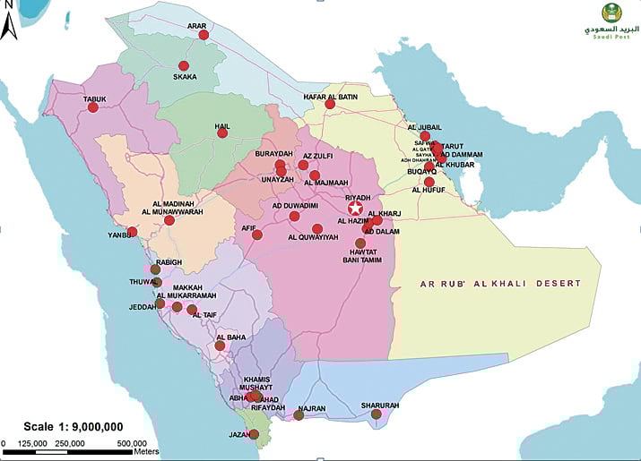
ArcGIS played an important role as a solution for approaching this geographic problem of assigning postal codes and addresses for improving mail services. Saudi Post divided the Kingdom of Saudi Arabia into postal regions, then divided these into branches, which were further separated into divisions. The divisions were then broken into postal quarters, which were assigned postal codes. This 5-digit number represents region, sector, city, and zone.
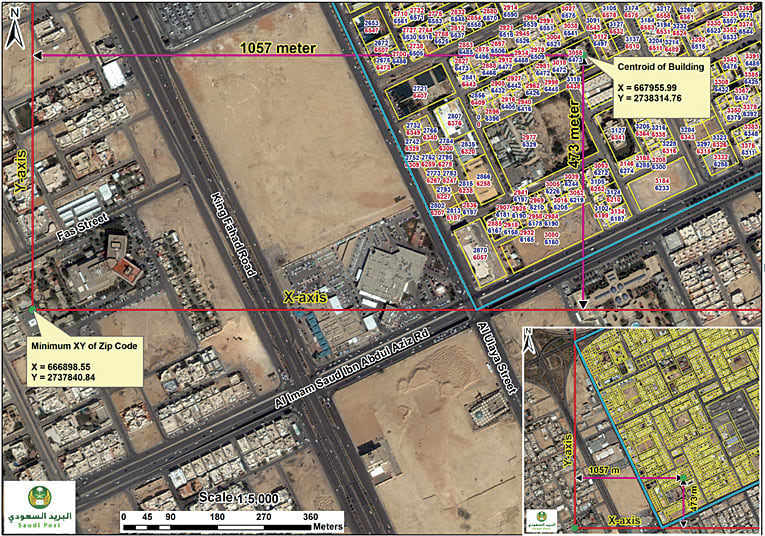
With the launch of the Unified National Addressing System, Saudi Post began assigning postal addresses by calculating x-coordinates with an absolute value between 2000 and 5999 and y-coordinates with an absolute value between 6000 and 9999 for each location inside the kingdom. The x-coordinates are the building numbers. The y-coordinates are the additional numbers for buildings that face an east-west road. Conversely, for the buildings that face a north-south road, the y-coordinates are the building numbers and the x-coordinates are the additional numbers. Also, the building is assigned an odd number if it is on the right side of a north- or eastbound road, and the building is assigned an even number if it is on the left side of a north- or eastbound road. This way, Saudi Post succeeded in assigning a unique and systematic postal address for each location inside the kingdom, with each 13-digit address consisting of a unique combination of 5 digits for the postal code, 4 digits for the building number, and 4 digits for additional numbers.
ArcGIS Mobile has made it possible for Saudi Post’s mail dispatch management system to accurately track and efficiently route courier delivery. Envoys at the distribution center disburse bundles along with a list of mail recipients to couriers, who carry handheld mobile GIS/GPS devices. Using these devices, they upload the address list to Saudi Post’s GIS, which in turn computes it and provides each courier with the best route, thereby speeding the delivery service. When a courier reaches a delivery point, the handheld system reads a chip implanted in the mailbox, which confirms that the courier reached the box. These handheld devices contain a locator so that couriers can be tracked by each delivery center. Couriers also use the device to update and make edits to the database from the field.
Saudi Post uses GIS for other types of analyses. A road network data analysis and distribution analysis includes evaluating relationships of road centerline data layers, parcels and point layers, and postal code polygons. A buffer analysis is used to equally distribute home and building route assignments to couriers.
“Our huge database is an integration project that serves our demanding e-services and applications,” notes Ali H. Bakheet, GIS director of Saudi Post. “It reflects daily updates.”
These e-solutions add value to Saudi Post’s GIS and geodatabase. The team developed an online postal Web locator that allows government, businesses, and the public to interact with postal data via an interactive map. Web tools on the back end of the Web site help staff and contractors maintain addresses, postal plates, and box data for every parcel in the kingdom. Government and private authorities, including banks, are using the system to verify addresses for clients and customers. Commercial establishments, such as fast-food companies, also access the GIS to help them deliver their products to customers. A new integrated service, e-mall, makes it possible for a person to buy a product via the Web site and have Saudi Post deliver it to the customer’s home.
Saudi Post now annually delivers 900 million pieces of mail. The immensity and quality of the change has been noticed by the international community. In 2009, Saudi Post received Esri’s prestigious GIS Technology Innovation Award, as well as awards from Cisco, Microsoft, and Oracle. The United Nations Universal Postal Union also recognized Saudi Post’s innovative program as a proof-of-excellence project.