To Locate Potential Habitats in Abandoned Mines, Organization Employs a High-Accuracy GIS-Based Workflow
Caves hold a special place in human history. Once a common home for people, caves today have become a destination for hikers, spelunkers, and other hobbyists. But they’re also used by another set of residents: bats.
Unlike humans, who have mostly abandoned their long-term leases on caves, bats today thrive in certain subterranean environments. And in a twist of fate, society has created a new type of sanctuary for bats: abandoned mines.

Not all old mines make great bat homes, though. Bats require a particularly ideal combination of moisture, temperature, lack of predators, and other factors. Only a choice subselection of abandoned mines allows bats to thrive.
That’s where Bat Conservation International (BCI) comes in. For 40 years, the organization has worked to prevent the extinction of bats by protecting their habitats. And now, thanks to a new high-accuracy mobile workflow based on GIS, BCI can locate and safeguard bat-friendly mines more precisely than ever before.
To Protect Bats, BCI Surveys Abandoned Mines
There are more than 1,400 species of bats all over the world, and although they are critical to the ecosystems in which they live, bats are among the world’s most vulnerable wildlife.
In much of the United States, bats are essential to controlling insect populations—their primary prey—and even consume crop pests in large quantities, reducing the need for large-scale pesticide use. In many other parts of the world, bats serve as important pollinators and seed dispersers for numerous fruits, cacti, and other plants—all of which would disappear without the bat species they depend on.

“Bats lead us to the best opportunities to protect nature anywhere in the world,” said Mike Daulton, executive director of BCI.
A collaborative and data-driven nonprofit organization, BCI’s work is largely funded by grants and relies heavily on the aligned goals of both federal and regional land management organizations, such as the Bureau of Land Management (BLM). BCI’s staff of about 30 employees works on preserving 35 critically endangered bat species, 3 of which are found in the continental United States.
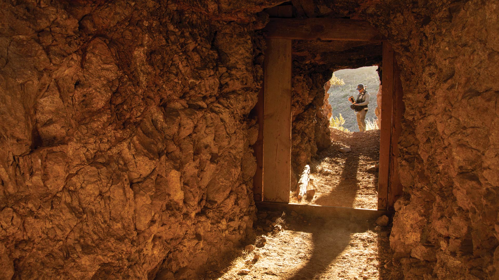
As part of an ongoing project that started more than 10 years ago, BCI has been working with BLM to survey thousands of abandoned mines across the western United States to determine which ones offer the best bat habitat. BCI staff members are specifically trained and qualified to safely enter and assess abandoned mines, which present unique hazards and should not be entered by the public. After evaluating the conditions inside a mine, BCI employees learn if and how bats use the mine so they can recommend specific actions BLM can take to allow bats to thrive there, such as installing gates that discourage human entry.

“A big part of our work is to survey abandoned mines so that we can recommend appropriate action,” said Priyesh Patel, geospatial products and data manager at BCI. “We’re contracted to do this for many public land agencies, including the BLM.”
In the past, BLM and its regional partners provided BCI with the locations of abandoned mines as either shapefiles or in spreadsheets. BCI would then load this data into ArcGIS Pro to create web maps. Mobile crews could use the web maps to visit and record the conditions at each mine.
But recently, BLM asked BCI to create its own inventory of abandoned mines for a project in New Mexico. Patel, who leads BCI’s geospatial work, had to create an entirely new workflow for this.
The Process of Finding and Safeguarding Bat Habitats
First, Patel used a topographic map of public lands from the United States Geological Survey (USGS) to try to determine known entrances to abandoned mines. After spotting patterns in the maps that indicate probable mine entrances, Patel used ArcGIS Pro to digitize these openings into points. To supplement his topographic map detective work, Patel also referenced satellite imagery, which allowed him to identify more potential mine locations.

The next step was to visit and verify the mines. Patel knew his mobile crew would need submeter accuracy to do this because abandoned mines often have multiple entrances located close together.
“Some mines are clustered together because they follow a common vein of ore,” Patel said. “Due to this clustering, it’s actually not that uncommon to have two or more mine openings that connect a few feet in. Using cell phone GPS, [which] is often off by several feet and sometimes up to 20 meters,…wouldn’t result in accurate mapping of features, especially when in a cluster. This caused us to realize that we needed to verify each unique mine opening within a few feet.”
Patel purchased two Arrow 100 Global Navigation Satellite System (GNSS) receivers from Esri partner Eos Positioning Systems to use for data collection along with ArcGIS Collector and ArcGIS Survey123. The Arrow 100 allowed Patel’s crew members to navigate precisely to the points he had digitized and either verify, reject, or update the mine locations. If crew members deemed a point valid, they then used Collector to create the final inventory of the mines, and Survey123 to record rich attribute data for each mine, including its temperature, humidity measurements, and whether crew members detected insect parts or guano (bat droppings).

From this data, Patel can easily run a query on the mines BCI crews have visited to determine which ones constitute excellent, good, moderate, and poor bat habitats. Using ArcGIS Online, Patel also created web maps and dashboards that visually display this data so anyone can see the status of each mine.
Any mine designated an excellent, good, or even moderate habitat for bats is recommended for long-term protection, triggering action by BCI’s land management partners. This often means protecting the mine from human interference, usually by erecting barriers that close off the mine entrances—especially for mine openings that are near roads.
“That simple gesture can lower disturbance and help provide bats with an undisturbed environment in which they can thrive,” said Patel.
Early Successes Give Hope for the Future
So far, Patel and his team have verified the locations of 785 mining-related features in New Mexico using their high-accuracy mobile surveys. Of these, about half—or 308 features—have been fully surveyed. Out of those 308 surveyed locations, only 8 show signs of being live bat habitats. That in itself emphasizes how difficult and critical it is for bats to thrive in unprotected areas.

Initial feedback from BLM has been positive. Patel hopes that in addition to recommending meaningful closures to ideal mines, BCI staff members will be able to revisit the mines years from now to determine if the closures have had a positive impact on bat populations.
“I hope that one day we can [return] to monitor the area and see if this work has helped to improve bat habitat,” said Patel.
In the meantime, BCI has expanded its high-accuracy mobile mapping workflow to assess raptor nests related to mine closure work in southeastern Utah. The team is also using the Arrow 100 GNSS receivers with ArcGIS Field Maps to georeference point clouds, taken with terrestrial lidar, that don’t have built-in GPS capabilities.
“It’s been fun experimenting with what is possible,” said Patel. “Our goal is to get us to the point where land managers can look at data from afar and make good decisions based on the data.”