Now more than ever, communities have tools at their disposal to make them smarter, more agile, and more accessible to everyone. GIS plays a huge role in that, and Esri partners are available to help users streamline their GIS processes and keep their geospatial technology up-to-date. Read on to find out how five Esri partners have used their GIS expertise to assist a city in making a smart growth plan, enhance a sidewalk navigation app, help standardize a call-before-you-dig program, and put together a road map to upgrade GIS according to what customers want.
Town Makes Smart Growth Plan—And Shares It
The Town of Bennett, Colorado, located 20 miles east of Denver International Airport, is experiencing record-setting growth. Over the next 10 years, it is expected that the number of households will increase by 300 percent—from just under 1,000 to more than 4,000.

Understanding and managing this growth responsibly are priorities for the town. With a grant from the Colorado Department of Local Affairs and the Adams County Parks, Open Space & Cultural Arts department, the local government was able to work with multiple consultants, including North Line GIS, to put together a capital asset inventory and master plan. Through this collaboration, the Town of Bennett evaluated its current infrastructure; developed a growth plan; and implemented ArcGIS technology as the primary access point for employees and consultants to retrieve and use data, information products, and presentations. Because of how easy it is to use, ArcGIS Online was chosen as the primary platform for gathering and presenting data.
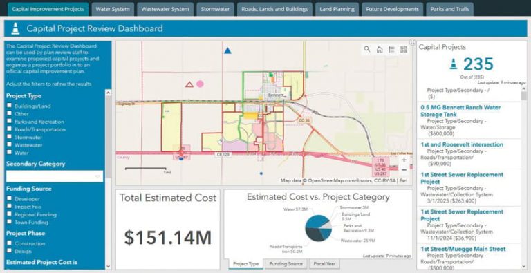
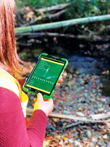
Employing the capital asset inventory and master plan—along with apps, including Collector for ArcGIS, Survey123 for ArcGIS, and Operations Dashboard for ArcGIS (which were all specially configured)—consultants and staff completed assessments of Bennett’s water resources, sanitation and storm water systems, land use, parks, roads, and buildings. They attached images, spreadsheets, and asset manuals to the features. They also logged the capacity and condition of all town-owned assets in ArcGIS so the local government can identify priorities and triggers for capital improvement.
Once the data had been compiled, consultants and town staff used Web AppBuilder for ArcGIS and customized templates to capture and update data and come up with best practices for ongoing data maintenance. Configurations include the Capital Project Review Dashboard that pulls from feature services used by multiple apps. To ensure ongoing success, North Line also trained town staff on how to use the apps and make configuration changes as needs arise.
Additionally, North Line helped staff develop a series of internal story maps to serve as a single point of access for all the apps. This makes it easy for various departments within the Town of Bennett to quickly and easily retrieve the information they need.
Now, Bennett has easy access to all the data and tools that can show how development will impact the town’s infrastructure and budget, so it can address growth head on instead of waiting for it to happen.
A Sidewalk Accessibility App Gets Upgraded
Sidewalks should be accessible and safe for everyone, no matter their abilities. That’s why pathVu is building a global map of sidewalks, pathways, and trails to improve accessibility and walkability. The company’s pathVu Navigation mobile app, which works with other accessibility solutions available on smartphones, uses real-time, data-driven maps to help pedestrians steer clear of sidewalk obstructions and hazards. For users in wheelchairs, for example, pathVu applies what it calls the Route Accessibility Index (RAI) to let them know where it’s safe to cross the street based on the conditions of the sidewalks and whether or not there are curb ramps.

The data used in the app is collected with PathMet, a device equipped with sensors that records sidewalk conditions and identifies things like tripping hazards, surface roughness, and pathway width. This geolocated data, complete with photographs when possible, can let cities know where they are failing to meet quality standards for their citizens and help them prioritize improvements that need to be made to sidewalk infrastructure.
Although pathVu Navigation was already operational, the company wanted to enhance and fix certain aspects of the mobile app to make sure the code was up to standard and verify that it was following best practices. So pathVu worked with Chetu to help with iOS and Android development and ensure that all back-end features could be incorporated into the app. Chetu, a custom software developer, was also recruited to help improve pathVu’s GPS precision and strengthen the mapping features that would encourage users to make pathVu Navigation their main navigation app.
The app’s code was originally written in Apple’s Swift programming language, so Chetu’s ArcGIS certified developers followed the same structure. They used ArcGIS Runtime SDK for iOS and ArcGIS Runtime SDK for Android, as well as the Xcode 9.4 integrated development environment (IDE) for the Mac operating system. Chetu also worked on the Android version of the mobile app to fix bugs and bring it up to speed, integrating the same functionality into the Android platform as it did in iOS.
Now, pathVu Navigation can provide custom navigation for users based on their comfort settings in the app. This means that routes are based on their abilities to navigate certain conditions rather than just the shortest route (which is how the app operated before). In addition, the app can alert users to particular points of interest based on favorites they have set up in the app. pathVu Navigation is available to download for free from the App Store and Google Play.
Web Maps Help Prevent Damage to Water Lines
In Loudoun County, Virginia—about 40 miles west of Washington, DC—more than 80,000 households receive their drinking water and wastewater services from Loudoun Water. The utility maintains more than 1,250 miles of water distribution pipelines; over 950 miles of wastewater collection system pipelines; and an expanding system for reclaimed, nonpotable water.

Loudoun Water is continually improving how it prevents damage to its underground infrastructure, instituting best practices championed by the Common Ground Alliance, an association committed to helping members ensure the safety of their underground utility facilities. One system that is crucial for safety and damage prevention is a Call 811 line, which allows residents and businesses to dial that number before beginning a digging project to ensure that they avoid all belowground utilities.
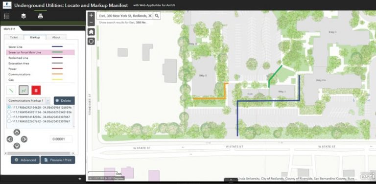
For its own call-before-you-dig needs, Loudoun Water implemented a Web AppBuilder for ArcGIS widget from Avineon, Inc., called Mark 811. Mark 811 is a ready-to-use, configurable tool for both web and mobile environments that’s accessible via web browsers on desktop computers and mobile devices. It enables employees and contractors to use web maps to identify where facilities are and generate manifests (electronic records that show the marked locations of underground utilities) that are submitted to the appropriate Call 811 center.
With Mark 811, Loudoun Water’s fieldworkers now use their mobile devices to document work. And by extending the power of enterprise GIS to include 811 functions, Loudoun Water has been able to generate a logical workflow for standardizing how manifests are created and submitted.
“The Web AppBuilder widget approach to this critical business function has enabled us to deliver meaningful user experiences and functionality to our stakeholders,” said Celine Yang, a GIS analyst at Loudoun Water. “It provides us [with] ease of deployment and an effective way to operationalize web applications in line with our web- and mobile-friendly digital strategy for utility operations.”
In the first three quarters of 2019, the utility used the widget for more than 11,000 manifests, reducing the amount of time it took to prepare and generate them and increasing overall efficiency.
Mark 811 is available on ArcGIS Marketplace.
City Sees a Clear Path for Moving Forward with GIS
The City of Griffin—part of the Atlanta, Georgia, metropolitan area—has been using ArcMap and ArcGIS Server for years to support its planning efforts and improve asset management. To continue to meet regulatory requirements, refine its overall operations, and embrace recent technology releases, the city recently set out to examine what it would take to move to the cloud and transition to ArcGIS Pro and ArcGIS Enterprise, as well as evaluate its existing hardware and network infrastructure. Griffin reached out to the GIS and IT experts at eGIS Associates for guidance.

To see about getting the city current on Esri technology and explore what would be required to implement ArcGIS Pro and ArcGIS Enterprise, eGIS conducted a Geospatial Road Map analysis for the city. The analysis provides an impartial look at an organization’s GIS to find out how it aligns with stated goals, mandates, and objectives. For Griffin, the Geospatial Road Map analysis also included an inventory of the hardware, software, and data associated with the city’s GIS; interviews with GIS and IT staff; and collaboration with the GIS manager, who provided insight into the city’s long-term goals and current product demand. eGIS also interviewed Griffin’s GIS customers, which include elected officials and leaders and staff from other city departments, to determine their current level of satisfaction with the GIS products and services they receive, as well as possible future needs in these areas.
“During the interviews, we found the customers were very happy with the products they were receiving from the GIS division but knew more was possible,” said Tripp Corbin, CEO of eGIS Associates. “The GIS team and city departmental directors also realized they could be doing a lot more with GIS. They are excited about the possibilities that new technologies, such as ArcGIS Pro, ArcGIS Enterprise, and ArcGIS Online, will bring to the table to improve daily operations. This support will be critical to the growth and success of GIS at the city.”
eGIS compiled and analyzed all the gathered information to develop a road map of recommendations and priorities needed for the city to successfully implement ArcGIS Pro, ArcGIS Enterprise, and ArcGIS Online.
“The Geospatial Road Map report we received from eGIS provided us with a very clear path to move forward as we implement new products and technologies from Esri,” said Brian Haynes, the GIS administrator for the City of Griffin. “We feel that we know the answers to the questions we started with and a lot more. The eGIS staff members were a pleasure to work with, and we were very pleased with their thoroughness and professionalism.”

