A consumer goods company wants to keep better tabs on key business metrics; a water utility needs to move to the cloud; a city makes a new, future-oriented master plan—and Esri partners help implement the GIS for it all. Read on to find out about these stories and more.
Implementing ArcGIS Utility Network
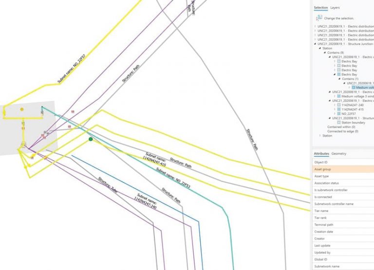
Norwegian utility Lyse is planning to go live with ArcGIS Utility Network for its electricity distribution grid by the end of 2020. To help Lyse successfully migrate to Utility Network, the company enlisted Similix, which has developed a complete solution for this.

Lyse is a longtime Esri user that employs a geometric network in ArcGIS Enterprise. One of the reasons Lyse became an early adopter of Utility Network in Europe is that the company wanted to employ the extension’s new services-based architecture, rich data model, and data integrity rules. Additionally, Lyse is one of the founders of Europe’s Utility Network Community (UNC), which helps organizations collaborate around Utility Network. Thus, Lyse has aided in developing a data model for European-style operated grids, which is the foundation for its own Utility Network implementation and that of several other utilities in Europe and Asia. This asset package, which has a data model, rules, symbols, and sample data, is available from UNC and can be downloaded for free.
Lyse’s implementation of Utility Network is phased. It starts with a full migration from its geometric network to Utility Network and then transitions to a delta integration, wherein the two systems run in parallel for a time while Lyse approaches change management one business process, integration, and app at a time. Similix is supporting all this with standard software from its Utility Network Migration Suite, which has an intuitive, drag-and-drop interface; allows users to define rules for enriching their data during the migration process; supports going live in phases for the delta integration; and enables utilities to run migration iterations based on their own data.

For Lyse, Utility Network will serve as a master asset data system and also provide asset data to other systems, such as Norway’s transmission system operator. By the end of 2020, Lyse will have also integrated a new enterprise resource planning system with Utility Network to manage asset maintenance, work orders, and project information. This will allow Lyse employees to conduct spatial analytics and visualization through ArcGIS Enterprise, both on the web and via mobile devices.
Each phase of the project provides Lyse with new web map-based information products as well that can monitor specific types of assets or voltage, for example. This ensures that everyone at the company can benefit from Utility Network data.
“The Utility Network technology [combined] with an open common data model—UNC—will drive our business forward,” said Sigve Hamran, GIS manager at Lyse. “It will be the central platform for designing and managing the life-span of the electrical grid, including new distributed energy sources and smart devices.”
Seeing Operations Unfold in Geographic Context
The consumer goods market is highly competitive. To stay relevant, companies need to continually innovate and use technology to better understand their businesses.
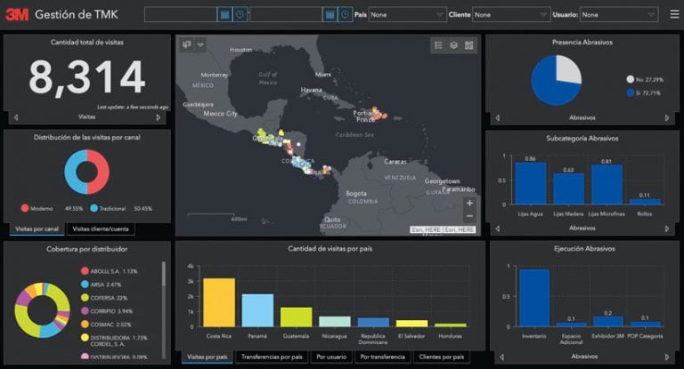
3M is a leader in this field, offering products that range from health-care technology to office supplies, and even it is not exempt from these market rules. Recently, its hardware store sales and marketing team for Central America and the Caribbean was looking for new ways to use technology to improve key business metrics, such as distributors’ points of sale (POS) coverage, how deeply its more than 30 product categories have penetrated the market, and how productive the team is across seven countries.

The company chose Intelligis Technologies, a recognized leader in producing commercial GIS apps in Latin America, to implement a real-time solution that managers now use to see 3M’s operations unfold in geographic context. This way, 3M can help its distributors identify opportunities to improve their business performance.
Intelligis implemented ArcGIS Survey123 to allow a mobile force of more than 40 trade marketing specialists to report conditions at POS sites and immediately take action where needed. For example, if a distributor is low on or out of a certain product, the trade marketing specialist can submit a purchase order right then and there through Survey123. Intelligis also used ArcGIS Web AppBuilder to create an app that, among other things, allows users to download all this field information in CSV format. Additionally, the solution employs ArcGIS Dashboards to show indicators such as the number of POS visits each trade marketing specialist makes, that person’s coverage area, and each distributor’s market share.
“This tool allows me to know, in real time, exactly in what POS [sites] my products are not present and to take action immediately in order to increase sales, penetration, coverage, and overall productivity,” said Juan Carlos Espinosa, regional manager of the hardware store channel at 3M in Central America and the Caribbean.
Eighteen months after the solution was implemented, 3M presented it as a success story to its business leaders in the region. The company is planning to roll it out to the rest of Latin America.
Getting Help Moving to the Cloud
Connecticut Water Company (CWC) is a regulated water utility that services many water systems across Connecticut and Maine. Its GIS team, which is distributed throughout New England, was experiencing lagging desktop performance and unpredictable outages that affected its ArcGIS software and apps. The team’s GIS needs were also heavily straining IT staff and resources, who needed to focus on customer-facing issues.

So CWC brought in ROK Technologies to develop a cloud-based GIS plan that could meet its needs. The three-step plan consisted of the following:
- Relocate CWC’s entire enterprise GIS infrastructure to the cloud using ArcGIS Enterprise, ArcGIS Web Adaptor, ArcGIS License Manager, and an SQL database.
- Move the GIS team to Amazon Web Services (AWS) WorkSpaces to effectively run programs—such as ArcMap, ArcGIS Pro, and Bentley Systems’ OpenFlows WaterGEMS—without interruption.
- Ensure that CWC’s GIS needs are continually supported and properly maintained via ROK’s managed services.
Once CWC’s GIS was moved to the cloud, the company’s GIS editors immediately experienced superior performance.
“It was an instant fix for us,” said Daniel Goodrich, senior GIS analyst at CWC. “Performance-wise, the cloud was better. We started working the way we had always imagined we should be able to work, without all the little hiccups.”

Overnight, CWC was able to deploy fast, reliable, and secure web maps to its mobile crews and office staff. Moreover, the solution offered excellent performance from any location, a reliable platform from which to serve GIS apps, and a way to reduce GIS demands on the company’s internal network and IT staff.
“With ROK’s managed services, we now have a team of IT experts who specialize in GIS,” said Goodrich.
Today, CWC not only provides better GIS information to staff throughout the company, but it also better serves its customers. And what is Goodrich’s advice for other organizations considering a move to the cloud?
“Go to the cloud right away, especially with a managed solution like [that from] ROK,” he said. “They handle all the stuff we don’t want to.”
This allows CWC’s GIS team to focus on what it does best—GIS.
Becoming a City Ready for the Future
Cities around the world are embracing a smart community philosophy and integrating technology across governmental functions to better address economic, social, and environmental responsibilities. The City of Orlando, Florida, is doing this via its Future-Ready City Master Plan, which leverages innovation and collaboration to enhance services and investments across seven functional pillars: connectivity, energy, health and safety, placemaking, mobility, water, and materials.

As the primary consultant for the Future-Ready plan, VHB has helped Orlando create a unified vision by working with the city to assess past investments, identify challenges to overcome, discuss future needs, and set priorities. This stepwise process was key to building consensus and defining a path forward.
One foundational element in particular was critical: engaging with stakeholders, including residents, the business community, educational partners, utility providers, nonprofits, and other local governments. The team at VHB also gathered input via internal city stakeholder discussions, roundtables on each pillar of the project, public workshops, and online surveys.
While the City of Orlando currently uses ArcGIS technology, including ArcGIS Desktop, ArcGIS Enterprise, and ArcGIS Online, the Future-Ready plan creates the opportunity for the city to expand its use of GIS and leverage the full potential of data to improve its operational and business results.
The Future-Ready City Master Plan is a living document and will be refined as technology and innovation progress and the world changes. While stakeholder engagement occurred prior to the coronavirus disease 2019 (COVID-19) pandemic, a midproject review revealed that the identified pillars and priorities were increasingly relevant to solving emerging challenges. Now, the team at VHB is preparing conceptual plans and business models to implement relevant actions and help the city achieve its vision of becoming the premier future-ready city, a global destination, and a place where everyone can thrive.

