The Esri Startup Program helps emerging businesses add location analytics to their services and solutions. Taking advantage of this support, these startups build revolutionary technologies for many industries, including public safety.
One such startup is Antris, which enables companies and organizations to track personnel—not just for improved efficiency, but also to ensure safety for remote workers in industries such as oil and gas, forestry, utilities, and social services.
Consider a social services organization that sends fieldworkers and volunteers on house calls. How can that organization verify that everyone is safe?

Big Brothers and Big Sisters of London and Area (BBBSOLA) is one such nonprofit organization that services the city of London and Middlesex County in southwestern Ontario, Canada. BBBSOLA develops and implements a wide range of mentoring programs through its community-based, school-based, one-to-one, and group programs. Today, BBBSOLA has more than 800 volunteers who cover 1,150 square miles of the community.
Although the organization is composed mainly of volunteers, there are typically 10 staff members who are responsible for tasks that include home and school visits and recreational outings. Such assignments often present travel or personal safety risks. These employees also have to tabulate the mileage and costs of their travel, as well as report on and analyze their activities to determine the organization’s reach within the community.
BBBSOLA used to do all this manually, using thumbtack mapping and buddy systems to monitor out-of-office activities, staff safety, and reporting. But this was time-consuming, inefficient, and often inaccurate. So the organization looked to automate these duties to enhance productivity, improve reporting and data accuracy, and save on costs.
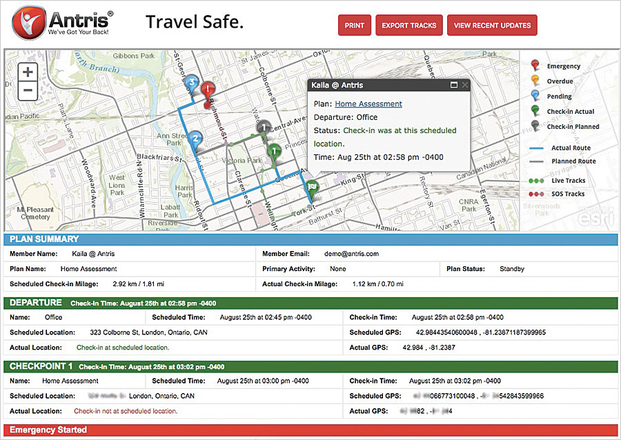
Seeking to quickly phase safety monitoring into staff members’ daily work routines, BBBSOLA engagement specialists and coordinators implemented AntrisPRO, a cloud-based app from Antris that employs the ArcGIS platform to enable BBBSOLA to map fieldworkers in real time.
When engaging with new volunteers during home visits, employees can use the app on their mobile devices to confirm that they have arrived and departed safely. It also lets employees do reporting from the field, and the app sends automated notifications to supervisors when workers may be at risk.
Unlike other fieldworker safety solutions that require investment in special devices, AntrisPRO leverages ArcGIS API for JavaScript to communicate with commonly used mobile devices, including iOS and Android smartphones, laptop and tablet computers, satellite phones, and GPS messengers. Because it is a cloud-based solution, AntrisPRO integrates with ArcGIS Online to ensure that basemaps are always accurate and up-to-date. Users can also share their own ArcGIS Online content with the app.
Additionally, AntrisPRO automatically provides a detailed report of the total mileage each user travels, which is essential for reporting. BBBSOLA is now able to use the app to assess how to improve time management by putting together snapshots of staff time in the community, how frequently they’re there, and where they need to enhance their work. AntrisPRO also captures data for how often each trip is traveled, generating a heat map of BBBSOLA’s overall reach within the community.
AntrisPRO allows BBBSOLA to save on both costs and time. The organization doesn’t need to hire an additional person to be available for employee check-ins and ensure safe arrivals and departures, which saves the nonprofit almost $1,000 per month. Documenting employees’ mileage used to take two to three hours to complete, but now that this is an automated process, employees can use those hours to do other work. And using the heat map lets BBBSOLA quickly and easily see how to better manage personnel and resources.
With AntrisPRO, BBBSOLA now has a reliable, GIS-based solution that ensures everyone’s safety while also making data easier to collate, share, and evaluate.
Get Started with the Esri Startup Program
Companies founded less than three years ago that build software or platform-as-a-service products and generate less than $1 million annually may be eligible to participate in the Esri Startup Program. This three-year program provides qualified businesses with free ArcGIS platform technology to integrate spatial functionality into their products. Learn more about the Esri Startup Program.

