Imaginative Professor Brings the Power of Community to GIS
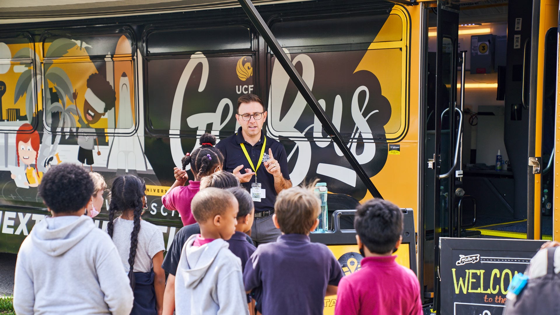
When the GeoBus pulls up to a school, the driver turns off the diesel engine, flips a switch, and the former city bus—now expertly painted with geography scenes and equipped with workstations rather than seats—becomes a solar-powered geospatial learning lab.
“From there, an entire class of students works in small groups of three or four through a variety of learning stations, spending 20–30 minutes on each activity. And what they’re doing is they’re being introduced to different geospatial technologies,” said Dr. Timothy Hawthorne, associate professor of GIS in the sociology department at the University of Central Florida (UCF) and the founder of the GeoBus.

There’s a 55-inch touch screen whiteboard that students use to visualize geospatial data in ArcGIS Online. They put on virtual reality goggles to take simulated trips around the world. There’s an augmented reality sandbox where students learn about topography, elevation, and contours. Three-dimensional, printed landscape models show the kids different terrains, from low-lying valleys to mountains and deserts. Laminated topographic maps from the United States Geological Survey and National Geographic familiarize them with basic wayfinding. Students also work with coding robots, learn to fly mini drones, and gather data on renewable and nonrenewable energy resources around their campuses using ArcGIS data collection apps and Bluetooth GPS receivers.
“It’s all about getting them excited about the technology and working as a team,” said Hawthorne, who, as a community-based researcher and public scholar, seeks to make GIS more inclusive of and engaging to a wider audience beyond the university setting. “The kids also get to meet UCF students, staff, and faculty so we can show them that there’s a possible major for them here and a host of career paths.”
Hawthorne thought of building a mobile GIS education lab almost 10 years ago, when he was an assistant professor of geography at Georgia State University and the state coordinator and director of research at the Georgia Geographic Alliance.
“Every state had one of these organizations at the time, and the idea was to connect K–12 educators and the broader education community with each other to build geospatial and geography learning opportunities,” he explained. “We did a lot of outreach where I would pack up my Prius or a colleague’s car and we would take everything we could to a school and set up shop for an afternoon. And I just thought, there has to be a better way—something bigger we can do.”
That’s when Hawthorne got the idea for a “geobus.” He couldn’t find anything like that in the United States, but he did find Columbia University’s BioBus, a mobile science lab that serves young people in New York City. So he connected with the team there and met with others in the mobile lab community to get ideas for how to build his bus. All this came together around the time he moved to UCF, however, so momentum waned for a while.
In the interim, Hawthorne—true to form, it turns out—worked on a lot of other, concomitant projects.
“He’s a big-idea guy, and he always follows through with those big ideas,” said Dr. Lain Graham, a senior solution engineer for the national government sciences team at Esri.
Hawthorne was Graham’s instructor when, as a graduate student at Georgia State, she took his study-abroad GIS course in Belize. He also advised her in her PhD studies at UCF. And now, Graham helps Hawthorne lead the undergraduate version of that research trip to the Central American country.

“It takes a big team to execute those ideas, and Tim recognizes that,” she continued. “He’s a very strong, collaborative leader, and he elevates people by enhancing their passions and augmenting those with additional skills.”
“I seek out projects where I might be strong in one thing and somebody else is strong in something else, and we come together to create really beautiful science,” Hawthorne affirmed.
Outside the classroom, Hawthorne does this through Citizen Science GIS, the research organization he founded that serves as an umbrella for various projects—many of which operate on grants from the National Science Foundation. These include, among other ventures, the GeoBus; the research trips to Belize; a program with the Smithsonian Institution that’s using drones to map eelgrass in the Pacific Northwest; and a project to help a water utility in Orlando, Florida, map its infrastructure.
For all these projects, Hawthorne makes sure “the work is authentically grounded in community,” he said, and that local residents and stakeholders are an integral part of the research process.
“Tim has changed the narrative in this respect and has challenged some of the more traditional approaches to doing GIS to make them more inclusive,” said Graham. “He involves local knowledge in data collection and provides space to include unstructured, qualitative data in the research. The importance of diversity and inclusion is something that Tim is very aware of and uncompromising on.”
In Belize, for example, Hawthorne and his teams have worked with local fishermen, tour guides, and boat captains to map coastal and reef environments. Community members’ knowledge is prioritized in the research, and their stories are augmented with quantitative data that researchers gather with drones and data collection apps.
“Tim is very careful to let us researchers know what our roles and responsibilities are on these projects,” explained Graham. “We are not the experts on the issues. We are there to collect data.”
Hawthorne wants his students and research teams to recognize how the data they’re gathering impacts communities and how those communities are part of the data.
“Data is incomplete when you talk about a community but you don’t actually work with that community. That leads to more inequality. That leads to lack of access and representation,” said Hawthorne. “What our work is really about is bringing those voices in and ensuring that the data is representative of those communities and that their stories are being put at the same level as some of the other, more authoritative data sources that you might normally find in GIS.”
When Hawthorne goes to Belize, he asks community members for permission to work in the area, whether they want to join the data collection team, and what questions the research team should be asking. When he works with kids on the GeoBus, he gives them the tools they need to do bona fide citizen science, like finding gaps in renewable energy sources on campus so they can encourage their teachers, principals, and school districts to make improvements.
“I would give this all up if I didn’t feel that it was moving other people’s lives forward,” Hawthorne said in a nod to one of his own mentors, Dr. John Krygier, professor of environment and sustainability at Ohio Wesleyan University.

Krygier’s class on the power of maps—which Hawthorne only took because it fit into his golf practice schedule—was the young college student’s introduction to geography.
“It completely blew me away,” Hawthorne recalled. “I learned how expansive geography was, and John—who is still a mentor and good friend of mine—was that professor who got me energized about the subject.”
Hawthorne took another class with Krygier and ended up with a funded summer research project mapping recreational trails in Delaware County, Ohio.
“I not only learned GIS, but I also learned how to do interviews with community members,” he said. “That was foundational for me because it showed that it wasn’t just about the technology; it was about engaging people with the technology and connecting people with society. All that came from John Krygier.”
Hawthorne, who is currently a 2022 National Geographic Explorer, said that, above all, he wants to be a good mentor.
“Anytime I can provide someone with the opportunity to work on something that they’re excited about, that really drives me,” he said.
And that drove him to finish the GeoBus project earlier this year. After procuring a bus and getting UCF students to help spruce it up, Hawthorne’s GeoBus dream became a reality in February. With the $30,000 grant that he received from being a National Geographic Explorer, Hawthorne and his team of “GeoBus drivers of change” hope that, by making two to three visits per week to schools around Florida, they can reach 10,000 K–12 students this year.
“Let’s build the next generation of people in science!” Hawthorne exclaimed.