“There was this dream I had to explore the world,” said Richard Resl.
Resl was an Austrian teenager fresh out of high school in 1984 and ready for adventure when he went to see a travel agent. He wanted to go somewhere tropical, a place not in the grip of cold weather or the Cold War. He wanted to experience a new culture and be in touch with nature.
The travel agent told him about a cheap flight to Peru.
“I asked, ‘What language do they speak there?'”
“Spanish,” said the travel agent. “You will pick it up.”
That first trip to Peru (with additional stops in Bolivia, Argentina, and Brazil) set the stage for what Resl would do with the rest of his life and where he would do it. “I fell in love with Latin America and the Americas. The people were so friendly,” said Resl.
This is how Resl—a tall, lanky Austrian with long blond hair and a passion for geography—ended up in Ecuador running the nonprofit AmazonGISnet organization. He teaches indigenous people from 11 nations how to use GIS and other geospatial technologies to protect their land in the Amazonian rain forest and their way of life.
After returning from his post-high school trip, Resl made a big decision. “I decided I wanted to become a geographer,” he said. One day in 1988 while studying in Innsbruck, he saw a poster on a wall for a seminar on GIS. Intrigued, he attended and was hooked.
He went on to earn a master’s degree in geography with a specialization in GIS from the University of Salzburg, where he was mentored in GIS by professor Josef Strobl. He then attended the University of Washington in Seattle on a Fulbright scholarship to do postgraduate work toward a PhD in geography and studied under well-known professors such as Nick Chrisman and Tim Nyerges.
Then, in 1994, fate stepped in and enticed him to return to Latin America. A physician was on campus looking for researchers interested in working in Latin America. The doctor wanted to hire a researcher with GIS knowledge to help him do epidemiological research in Ecuador.
The work involved studying where outbreaks of malaria and other mosquito-borne diseases were occurring based on location factors, such as living near a pond or lake or in a secondary rain forest, and social parameters, such as dwelling in an urban area with a sewer system or in a home with a grass roof.
After arriving in Ecuador, Resl soon began to branch out into other areas besides health research. He created a GIS database for the City of Quito’s municipal drinking water and sewer system. He got involved in a foundation called DIVA, sponsored by the Danish government, that studied biodiversity in relation to cultural diversity. Though he was becoming more fluent in the Spanish language, his other language served him well. “GIS was my language to get to know people,” Resl said.
The Day the Shuar Came Calling
Resl still vividly recalls the day in 1996 when strangers showed up at his house in Tumbaco. He was living in a small town in Ecuador that had views of the Ilaló volcano and—on a clear day—glacier-covered Mount Cayambe.
“They came from nowhere,” Resl said. The small group of Shuar men stood outside and stuck a spear in the ground. [The Shuar are indigenous people of Ecuador and Peru.]
“I couldn’t really [figure out] what they wanted. I brought them water,” Resl said. “Then I had them enter the house.”
Since Resl did not speak Shuar, he faced a conundrum. He needed to get work done, but the men would not leave. An idea came to him. He brought out a map and, using the language of mapping, asked “Where are you located?” They pointed to a place on the map. “I could see they were eloquent in using maps.”
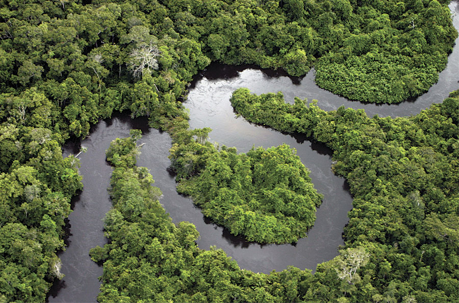
It turns out the Shuar wanted Resl to travel to their community. Three days later, he took an eight-hour bus trip to a small airport where a charter plane flew him into the Amazon. He was the only passenger in a small plane piloted by a man who said he absolutely would not stay with Resl once they arrived at their destination. “It’s quite dangerous,” he said.
“We flew over a vast ocean of trees with no gap in between. It was a one-hour flight, almost to the Peruvian border.” The pilot dropped Resl off at a small airstrip and minutes later was gone.
Resl stood alone.
“It was five in the afternoon, and I waited there for a half hour. I thought, ‘I am really lost.'”
Suddenly the Shuar appeared.
“I was so surprised. They were totally prepared,” he recalled. “The whole community was there with a greeting ceremony.”
As darkness fell, Resl grew uncomfortable as men with spears and painted faces approached him and told him to sit down. “I was really frightened.” However, a young man who spoke Spanish told him to stay awake and accept all food and drink offered. “If they give you something to drink and eat, don’t reject anything,” Resl recalls the young man saying. For 24 hours, Resl said he was observed and told to “defend yourself.” He thought he was going to be on trial. Suddenly, people came up to him bearing gifts such as jewelry and other Shuar crafts.
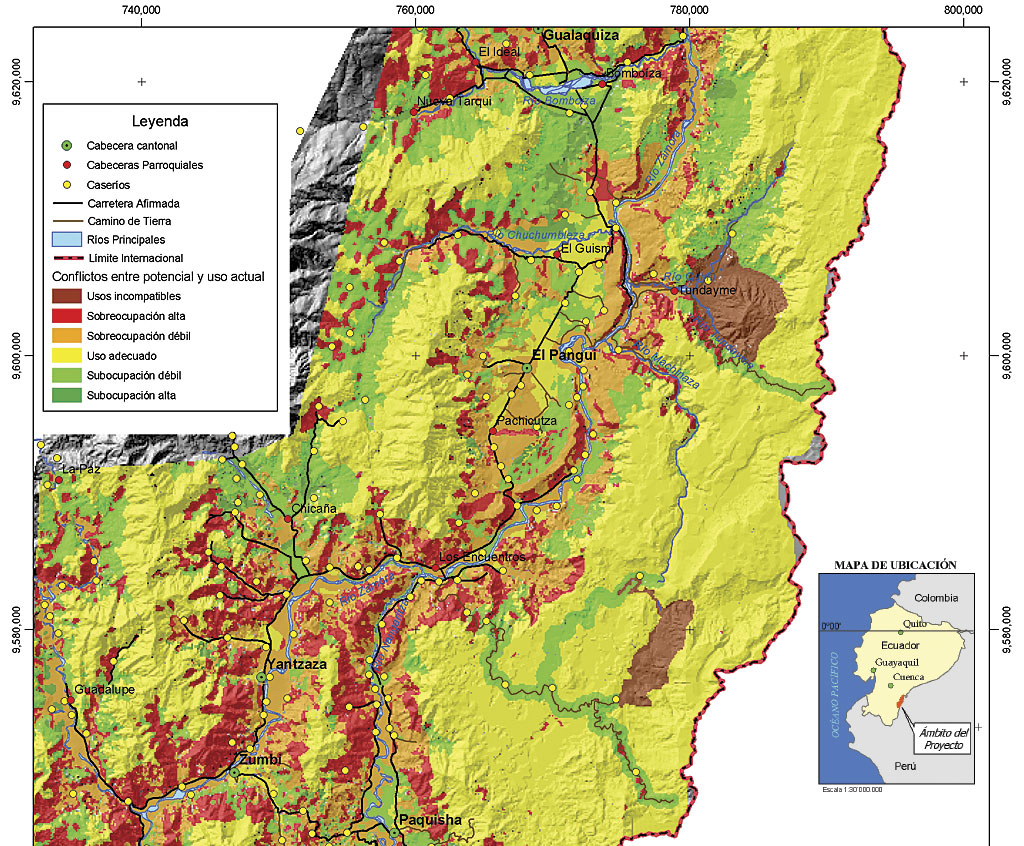
The Shuar knew Resl was a geographer and wanted him to map their land. They wanted to create a map of their territory to provide to the Ecuadorian government and create a management plan for their community. Indigenous rights had long been an important issue in Ecuador. The Confederation of Indigenous Nationalities of Ecuador had been formed in 1986 to organize a group of indigenous nations with the goal of gaining those rights.
With no roads—just jungle—Resl knew the job of mapping a territory of 220,000 hectares would be nearly impossible. So he told the tribe the work would cost them $20,000. “I thought, ‘They will now say no,’ but they said okay.”
Two years passed, however, before the Shuar returned to Resl’s home in Tumbaco. “They said, ‘We have the $20,000 and we need to go right now.'”
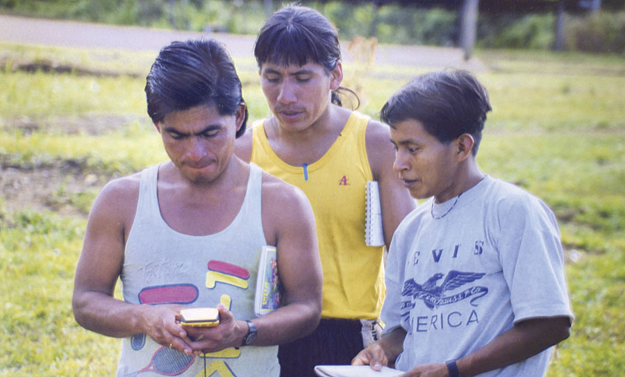
Resl went down to the water department where he was doing consulting work and got two GPS devices and a satellite image of the area. He also recruited a friend, a German engineer, to accompany him for the first two weeks.
Working with a small team of Shuar men, they spent weeks trudging through the dense Amazonian jungles collecting waypoints on GPS devices. They lived off the land, eating small animals and fish. Back at his office, Resl used Esri technology to make the map with the territorial boundaries using the waypoints collected with the GPS devices, the natural boundaries from the satellite imagery, and biodiversity information he collected during his time in the Amazon.
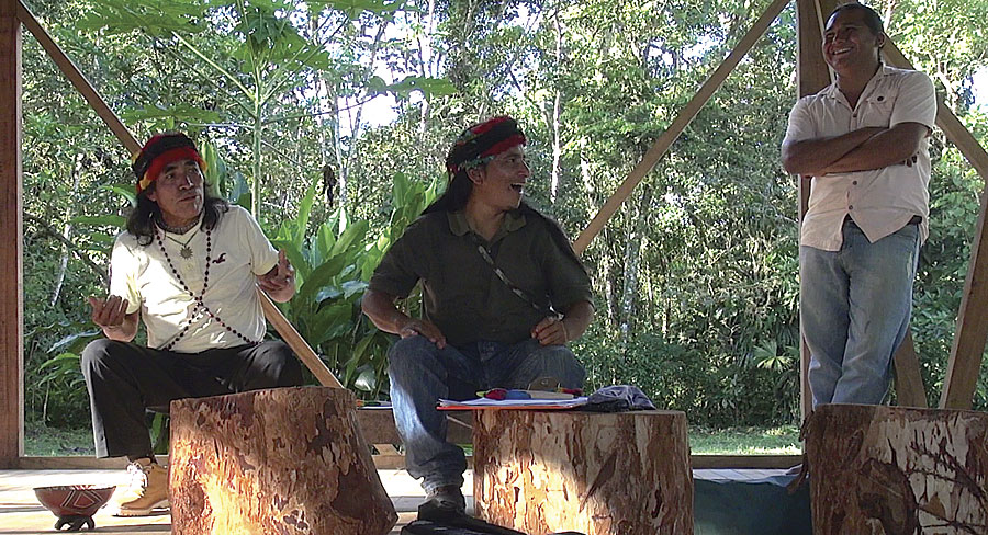
Resl later went on to do more mapping for the indigenous nations and out of that grew the nonprofit organization AmazonGISnet. He is now the coordinator of this network of members of 11 indigenous nations who use GIS as a tool for land planning and management. He works out of an office in Cumbayá, Equador, just outside of Quito.
AmazonGISnet offers training to indigenous students in GIS and other geospatial technologies. Resl said one goal is for the young people to create “life plans” for each territory that incorporate maps. These maps show how space is used within the territory, including where the women grow crops, where the men hunt, where the families live, and where environmentally sensitive land is located. The life plans also can include sacred and ceremonial sites.
Students also are embarking on a project to create story maps using Esri Story Maps apps, which they hope to share with the world via the web. “Maps are a means to explain identity and what makes up their identity,” said Resl.
A Sustainable Way of Life
Going forward, AmazonGISnet plans to continue supporting the indigenous people from the Siona, Secoya, Cofán, Waorani, Kichwa, Zapara, Shiwiar, Andoas, Achuar, and Shuar nations as they try to protect their way of life.
Changes are coming to the Amazon. Increased government-backed mining, oil, and logging concerns are reshaping the landscape and how people live. Resl hopes the maps the indigenous nations are creating with the help of AmazonGISnet will give indigenous nations a stronger voice at the planning table when land-use decisions are made.
The passing years have also brought changes to Resl’s life. Besides teaching workshops to the indigenous students through AmazonGISnet, he is an adjunct professor teaching geography and GIS at the Universidad San Francisco de Quito. He is also the program director of UNIGIS in Latin America. [UNIGIS is a worldwide network of universities that work together on the design and delivery of distance learning in GIS.]
He came up with the idea for a modern urban cable car system between Quito and the new growing central locations of the Tumbaco Valley and designed it. This system would help ease traffic jams on roadways and provide a high-quality public transport system at a low cost while decreasing pollution.
Cable car transportation would minimize fuel consumption and would limit the impact of the oil industry in indigenous territories, Resl said. “Domingo [Ankuash of the Shuar nation] already mentioned to the city authorities that if they don´t proceed with the project soon, he would take the lead with the Austrian cable car partners to build a transport system for his people over the canopy in the Cordillera del Cóndor [a mountain range] to connect his people and communities and avoid the construction of roads and the destruction that comes with them and show independence from the mining companies.”
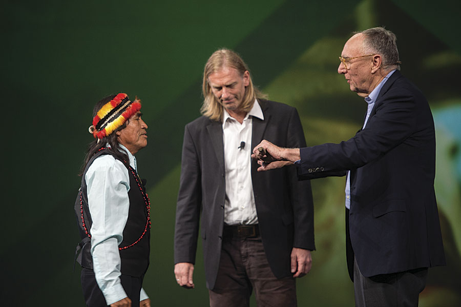
Accepted into their community two decades ago on a lonely airstrip in the Amazon, Resl stands with the Shuar and other indigenous people. At the 2016 Esri User Conference, with Ankuash beside him on the plenary stage, Resl accepted the Making a Difference Award for the work AmazonGISnet has done supporting participatory planning among the indigenous communities as they work to preserve their culture, create sustainable economic development opportunities, and protect the fragile environment in the Amazonian lowlands of Ecuador. They are continuing as the keepers of the rain forest, a role they fulfilled for the last thousand years, said Resl.