ArcGIS helps airlift food in South Sudan
The author, a GIS consultant who works for the United Nations World Food Programme (WFP), provides geospatial services that enable WFP and coordinating relief organizations to deliver aid to vulnerable populations. In 2013, she received the Esri Making a Difference Award for her work in Afghanistan, which was described in “Her Years of Living Dangerously: Fighting hunger in perilous places” in the Fall 2013 issue of ArcUser.
WFP, the largest humanitarian organization fighting hunger worldwide, has a primary mission to provide food to those who are unable to obtain it for themselves. On average, WFP delivers food to more than 90 million people each year. Of that number, 58 million are children.
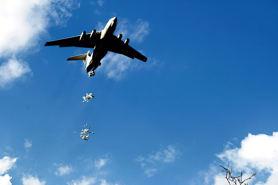
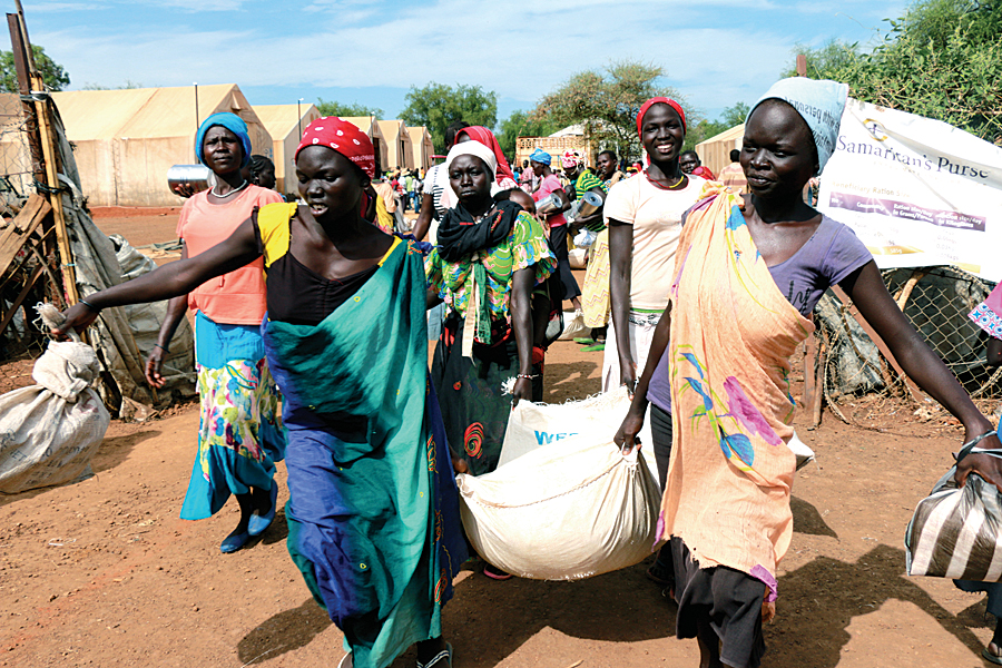
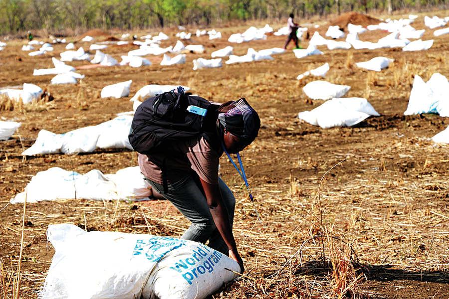
Since December 2013, WFP has been providing food and nutritional assistance to more than 90,000 people in many areas of South Sudan. Continued insecurity and fighting along the supply corridors in addition to the effects of the rainy season often prevent WFP from conducting regular deliveries of critical food supplies by road to South Sudanese refugees and internally displaced persons (IDPs) nationwide. Consequently, WFP has been providing food supplies to the IDP camps and maintaining food distribution to refugee camps in conflict regions through a combination of airlifts and airdrops.
Aircraft loaded with lifesaving supplies fly in from Asosa and Gambella in neighboring Ethiopia and from Juba in South Sudan. Following encouraging discussions with the Sudanese government, it may be possibile to conduct an air operation from Khartoum, the capital of Sudan, to assist villagers displaced in Upper Nile and Unity. In addition to air operations, plans are under way for the movement of barges along the Nile River from Juba to transport food commodities to Upper Nile state of South Sudan.
Mapping Improves Delivery of Assistance
A mapping component was introduced by the United Nations Joint Logistics Centre (UNJLC) in Sudan following the humanitarian crisis in Darfur in 2008. Insecurity in this area has continued and has limited the ability of UNJLC to deliver humanitarian assistance, leaving IDPs and vulnerable populations exposed to life-threatening risks.
To mitigate the effects poverty, limited infrastructure, malaria, and recurring natural disasters, such as floods and drought, has required a robust disaster preparedness plan. UNJLC continued to ensure coordination of logistics and information management to facilitate the timely and cost-effective delivery of assistance. GIS, including mapping services and logistics for emergency preparedness, was provided for key areas during the interventions in 2008. Following independence in 2011, the South Sudan WFP Country Office (CO) based in Juba continued to support the core concept of WFP through its eight sub and four field offices.
Humanitarian access is the main challenge for operations in South Sudan. During the civil unrest, WFP’s prepositioning of supplies was ongoing, moving food to strategic locations ahead of the rainy season, particularly for refugee operations in Unity (Yida) and Upper Nile (Maban) states. However, civil unrest, insecurity, and road closures due to the rainy season presented major challenges to both road and river transportation and storage facilities throughout the country.
After years of internal conflict, the world’s youngest nation had high levels of malnutrition. Much of the population was living below the poverty line. The country was again divided along ethnic lines. More than 100,000 of the 1.5 million people displaced by the fighting were living in UN peacekeeping bases. The only option the WFP had to reach these vulnerable groups who were in areas inaccessible by ground transport was using the United Nations Humanitarian Air Service (UNHAS) air assets. A combination of airlift/air bridge and airdrops worked for these areas, especially during the rainy season and periods of security instability.
Since GIS tools were introduced to the WFP CO in 2008, they have been used to support decision making for each unit within WFP and the Logistics, Food Security and Livelihood Clusters. [Clusters have become a standard business model for coordinating agencies and organizations providing humanitarian responses to sudden disasters and protracted crises.] These capabilities have been especially important to humanitarian access between South Sudan and Sudan. It is required for the emergency operational plan composed by WFP and nongovernmental organization (NGO) counterpart staff to distribute food commodities along with nonfood items (NFIs) for IDPs (items such as plastic sheets, mosquito nets, and jerry cans) within conflict affected states in South Sudan.
Maps were one of the key documents exchanged during bilateral discussions with the governments of Sudan and South Sudan to emphasize the importance of border crossing to reach IDPs in the conflict states of Jonglie, Unity, and Upper Nile in South Sudan.
All feature classes saved in a geodatabase could be extracted and analyzed easily using the data management tools in ArcToolbox. WFP CO purchased ArcGIS 10.2 with the ArcGIS Network Analyst extension for all spatial analysis and mapping tasks. The new built-in-tools made compiling the required maps fast and simple.
Due to the conflict situation in the country, the WFP headquarters in Rome declared South Sudan as a Level 3 emergency, its highest level emergency. All outputs from WFP contained maps. Maps were required for running the operation in South Sudan as well as keeping the regional office in Nairobi, Kenya, informed of the situation. Maps showed the location of IDPs; the road and river access constraints; the distance to each location from the food storage facility; any possible corridors for food supply and NFIs; and where organizations were present on the ground. Maps also showed the security situation and land use, helping WFP provide assistance immediately for the needy and vulnerable population affected by the civil conflict.
Almost all WFP sub and field offices were looted or destroyed. Staff continued to support food distribution based in United Nations Mission in South Sudan (UNMISS) compounds where they lived in cramped accommodations with limited access to Internet and e-mail.
If staff could have used their smartphones, they could have shared KMZ or KML files with the mapping unit by importing these files into a map document using the Import From KML tool in ArcGIS. However, due to government regulations, photographs, observation equipment, and smartphones could not be used without requesting permission from the government. That permission became more difficult to gain during the conflict. Access to governmental statistical data for IDPs became impossible to obtain, and satellite imagery was infrequently updated.
Using ArcGIS 10.2, staff could access the OpenStreetMap (OSM) basemap, which was especially useful where ground and detailed transportation data was not available. Using OSM as background data with the available spatial data helped make the ground situation understandable. This was especially important when deploying field staff for airdrop/air bridge food distribution. If the fighting resumed, it helped identify safe locations for staff and the security personnel who were monitoring the situation.
When the WFP CO received operational specific data from the field, that data was most often provided in Microsoft Excel spreadsheets. With ArcGIS 10.2, information in Excel spreadsheets could be dragged and dropped onto a map document and, within a few minutes, a map needed for planning and decision making was complete.
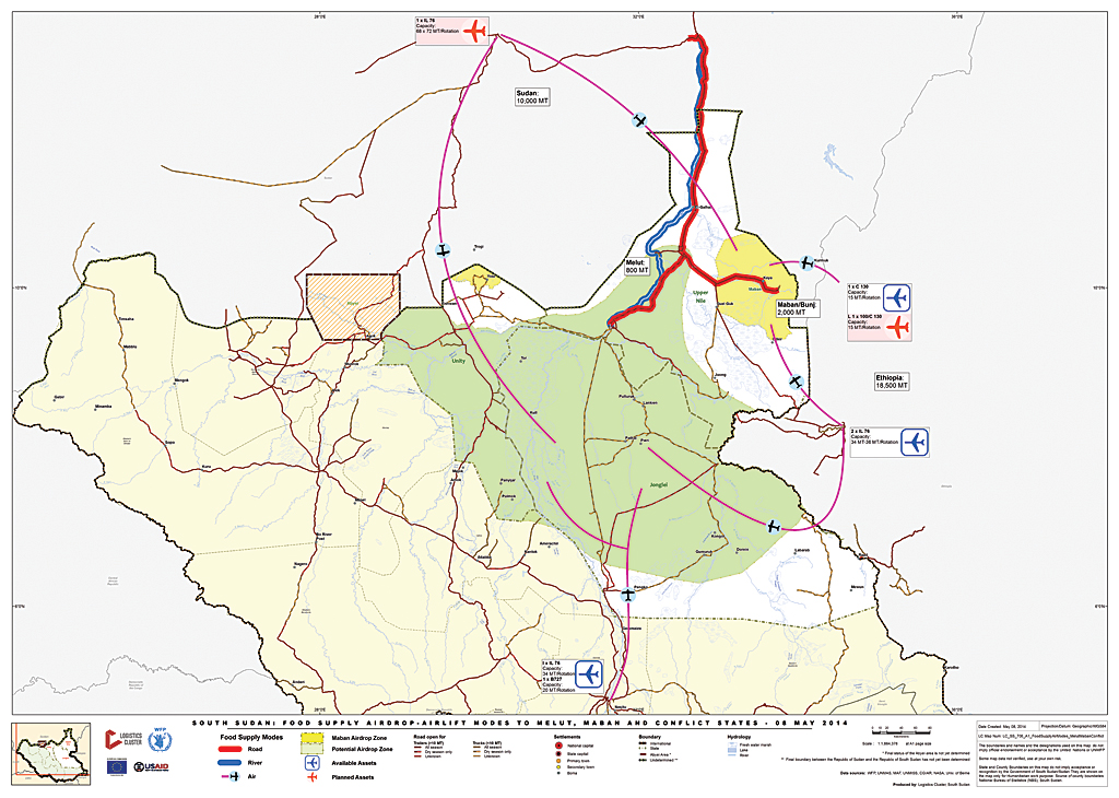
WFP partners, especially those who provide logistical support, need to act immediately. GIS is the key to identifying locations. GIS tools and UNHAS air asset data are used to create detailed maps that helped partners understand and plan air operations. Nautical miles were calculated within a couple of minutes to identify the type of aircraft, payload that could be carried, the distance to each drop location, and how many rotations that each aircraft could do based on the weather.
In addition to assisting in the effective use of air resources, GIS helps determine where aid is delivered by locating all IDP camps that require aid from WFP and its partner NGOs. It also identifies which WFP/Logistics Cluster service locations used by partners are free and which locations require a fee.
Logistics Cluster partners and NGOs have access to maps with the help of WFP, and the Logistics Cluster staff have provided better, more efficient service, in a timely manner based on needs and requirements. As the concept operation plan for the Logistics Cluster was created, a map was compiled that showed partners where common storage facilities and services were provided.
Easy-to-use maps have been shared by partners who use the facilities available at each location. During this emergency, ArcGIS tools provided tremendous support for WFP operations as well as the Logistics Cluster, Food Security and Livelihoods Cluster, and the Emergency Telecommunication Cluster in South Sudan.
For more information, contact Peter Schaller, head of logistics, WFP South Sudan or the GIS officer of the WFP Logistics Cluster.
About the author