If you want to know when the next city council meeting will be held, you live in Johns Creek, and you have an Amazon Echo, just ask Alexa, Amazon’s voice control system for its wireless Echo smart speakers.
Alexa can respond appropriately to your question because the City of Johns Creek, Georgia, developed an Alexa skill that makes key data about the city’s operations more accessible to citizens via natural language questions.
An Alexa skill is like an app that performs a specific task. Johns Creek, the first city in the world to use its open data with Alexa, won the Best Practices Award for Amazon’s City on a Cloud Innovation Challenge in June 2018.
The development of the Alexa skill is just the latest manifestation of the city’s commitment to using GIS and open data to enhance city services and drive its economic development.
An Exceptional City
Johns Creek, nestled along the Chattahoochee River in the gentle foothills of north Georgia, became a city on December 1, 2006. With an ethnically diverse population estimated at slightly more than 84,000 in 2017, it is known for its nationally ranked schools and abundant recreational opportunities.
The city motto is “Be the Exception.” Johns Creek has an exceptionally large entrepreneurial population—half the city’s licensed businesses are home based. It is a constituency that expects its city to be responsive and efficient. From its inception, Johns Creek has relied on technology, including GIS, to deliver a high level of service to citizens.
The city’s GIS department is a two-person team. That team is currently composed of Julie Kutz, a GIS analyst, and Nick O’Day, the city’s chief data officer (CDO). GIS falls under the IT department structurally and budgetarily, but the CDO reports directly to the city manager. Although there are no plans to add GIS staff, O’Day wants to expand their capabilities and deputize staff in other departments to do some of the work they currently handle.
This strategy has added benefits, observed O’Day. “In my experience, it’s better to develop other non-GIS staff to help do the work than it is to just add GIS staff. You get advocates for your work in other departments, and you also spread the knowledge and capability around.”
Making More Possible with Data
O’Day believes that the city realizes value from the democratization of information that the city’s open data site makes possible. Reaping the benefits from open data involves first making everyone—the public, businesses, and developers—aware that the city has high-quality data that is freely available.

In 2016, the city stood up the Johns Creek OpenData portal. Built using ArcGIS Open Data, the portal gave the public free access to its high-quality GIS data. Johns Creek wanted not only to provide better government transparency, it also wanted to encourage and enable businesses from mom-and-pop entrepreneurs to large corporations. In contrast, other cities in Georgia charge for this data. Access to data that is both trustworthy and free mitigates many of the risks faced by startups and small businesses.
The DataHub launched in 2017, expanded the availability of city data by incorporating nonspatial as well as spatial data to become a one-stop shop for all city data. By building automated methods for pulling in data, the DataHub included data from all city departments except human resources.
Not only was more data readily available but the site also provides interactive tools that help users discover, understand, and work with large amounts of city-generated data. Data can be inspected using the dashboards and charts available for some datasets or added to a web map in ArcGIS Online to take advantage of its smart mapping and analysis tools.
Videos show how to use the data to locate potential customers, find vacant and commercial sites, discover restaurants along a commute, and incorporate data services into an app. To provide instant information on popular topics, the site also has web maps with names such as Find A Business, Road Projects, and Parks & Recreation.
O’Day said the site has been engineered specifically to push dashboards and charts first and data second because “We want to drive understanding through the data, instead of just post a bunch of data layers and hope that people have the time, talent, or desire to dig into it.” Those dashboards and charts are embedded throughout the city’s website with links to the DataHub. The city’s communications department also Tweets and posts facts gleaned from the DataHub.
At the 2017 Esri User Conference, Johns Creek received the Special Achievement in GIS Award for its innovative application of technology, data collection, geospatial information visualization, and thought leadership related to its launch of the DataHub. Winning awards for DataHub has been a great way to validate GIS work in the eyes of skeptical citizens and provides an opportunity to say something new about the site.
The DataHub saves staff time that had been spent responding to requests for data. Contractors and developers have 24/7 access to the latest city data. Because the DataHub is built on ArcGIS technology, city data is accessible using the familiar ArcGIS REST API so developers and tech companies can build apps and support existing services.
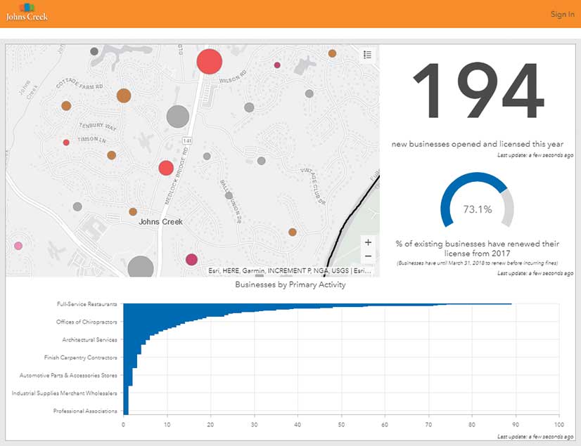
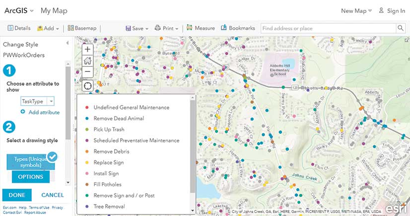
The five most frequently accessed data layers are police calls, fire calls, public works work orders, business locations, and financial expenditures. Nearly 10 percent of all DataHub traffic comes to the CreekView app. Originally built eight years ago with the ArcGIS API for Flex as an internal web viewer for GIS data, it was updated using the ArcGIS API for JavaScript and Web AppBuilder for ArcGIS.

Data Quality Is Key
Maintaining high-quality data is critical to the success of the city’s open data use. O’Day has a philosophy for promoting data quality.
“The key to good data is making sure that the people collecting it—from the GIS intern to the business license folks—all know why we need the data and what we can use the data for. Once you get staff to understand that an accurate address point means that firefighters can respond to someone’s house faster, or get a customer to a new bakery, or help count people for the census to ensure that funds are allocated fairly—and not just make a map look pretty—quality data collection is easy.”
The GIS staff and other key staff review the plans required to permit any new development or redevelopment project to ensure documents and CAD drawings are accurate and complete. Data is verified in the field using Collector for ArcGIS on iPads with an external GPS unit.
The city is working with Esri partner Mapillary on the #CompleteTheMap initiative to inventory the number and types of city street signs. The project uses the position of crowdsourced street-level photos submitted to the city by residents and Mapillary’s machine learning capabilities to derive street sign locations.
Making the DataHub Even Better
As beneficial as the DataHub could be for many applications, O’Day realized it was not intuitive for most people. A way for improving that situation occurred to him while he was listening to a presentation by Esri’s Andrew Turner at the 2017 Esri Developer Summit. He was talking about a project by the Esri R&D Center in Washington, DC, that would use Alexa to tell residents about garbage pickup days. He realized he could make getting information from DataHub a lot easier.
“Most of us are used to asking a question and getting an answer,” O’Day reasoned. By creating an Alexa skill, users wouldn’t have to use an app or search—they could just ask a question, and Alexa would use data the city was already collecting and maintaining to answer it. This would be a more natural way to find information.
O’Day worked with Gavin Rehkemper of Esri Professional Services to develop the Alexa skill and launched it in April 2018. The Alexa skill is free to enable so just by speaking to Alexa, not only can you bid Alexa to play music or control your smart thermostat, but now you can also ask her for information about the City of Johns Creek.
Enabling an Organization
By making information and tools easy to use, other departments will be more productive and self-sufficient. O’Day sees this as the best strategy for GIS departments. “When this happens, it elevates the kind of work that the GIS department does because it can focus on delivering analysis and insight instead of a stack of maps.”
A lot of GIS departments are so focused on making maps all day long that they don’t have the time (and haven’t developed staff) to do more powerful things,” said O’Day. “If someone is going to take the time to come and ask a question, I’d rather it be a deep question that takes some work to solve than ‘hey, can you look up what the zoning is of this property and make a site map for me?’”
Adopting this approach transforms the GIS department from an information bottleneck to an information conduit that powers the organization, helping improve efficiency and driving economic growth.
Many Benefits from Sharing Data
Johns Creek is the first municipality in the world to provide business data to Waze, the crowdsourced traffic navigation app. By sharing the city’s constantly updated business license data in addition to road closure and other data with Waze, residents and visitors can use the app to more easily shop, dine, and do business in Johns Creek while avoiding traffic delays.
Getting city data into the popular Waze app, rather than replicating its functionality in its own road closure app, lets Johns Creek amplify its road work notifications while alerting city staff to traffic congestion and other issues in real time. Johns Creek uses ArcGIS Online to share its data with Waze, and ArcGIS GeoEvent Server to pull data back from Waze into its system and make it actionable. An added benefit from this approach: Instead of reinventing Waze and other popular apps, the GIS department can concentrate on apps and data products that don’t exist and could benefit the city.
Johns Creek also shares data with Esri, HERE, TomTom, home builders, and others, to promote the use of spatial data for the city that has a uniformly high level of currency and accuracy.
What’s Next?
Johns Creek is a relatively new and modest-sized city with a two-person GIS department. That limits the number and size of projects the department takes on. However, the city is not burdened with legacy systems or GIS staff who work in siloed departments. Its GIS department is centralized and built on much newer technology.
“This helps us be a lot more nimble and also lets us experiment with cutting-edge technologies faster with key staff,” said O’Day. “If something doesn’t work, we dump it. We don’t invest a lot of time or money into a project unless we have a pilot or a really good use case ahead of time. This means that if we fail at something, we only lose the staff hours and maybe a few thousand dollars at most. If we were a large city or county, we’d have hundreds of hours and tens of thousands of dollars (or more) sunk into a project just to see if it is viable.”
With this startup-like approach, the GIS department continues exploring new information tools. Recently, it enhanced planning for a project to widen a major road by adding a dimension. The GIS department used Esri CityEngine and the Esri Labs ArcGIS 360 VR [virtual reality] app to create an immersive 3D environment so residents could see what the corridor would look like.
“I’ve seen a lot of different governments that have staff that are very entrenched in ‘this is what we’ve always done it’ and ‘why change it’ mentalities,” said O’Day. “None of that exists in Johns Creek. This staff is constantly trying to do better, do more with less, and to find new and smarter ways to deliver services.”
About the author