You’ve got a blockbuster of a story to tell that includes marvelous maps, fabulous photographs, and a riveting narrative. To help you tell your story simply, powerfully, and with style, Esri has developed ArcGIS StoryMaps (esri.com/storymaps).
This new story builder gives you intuitive tools to add maps, pictures, and videos to your narrative; incorporate stylish design; and choose from among predesigned themes that harmonize your story’s visual elements.
Why add a new storytelling builder to the repertoire of popular Esri Story Maps app templates like Story Maps Tour, Story Maps Cascade, and Story Maps Journal?
Well, here’s the story.
Esri has been enabling place-based multimedia storytelling for more than seven years, providing everyone—from GIS professionals to journalists and from conservationists to scientists—with the app templates to tell compelling stories about their work. Almost one million stories have been produced using the classic templates.
But time and experience taught members of Esri’s StoryMaps team—who develop and test the builders and make story maps themselves—that changes needed to be made. The project to design a next generation product launched in 2018. It quickly became clear that to incorporate new features and improved performance capabilities, the team needed to create a new resource rather than continuing to incrementally upgrade the existing storytelling templates. The key benefit of this decision is that you can create a variety of story formats within a single builder.
Based on lessons learned by the team and feedback received from thousands of people across the large Esri Story Maps community, ArcGIS StoryMaps was developed to include the following features:
- A single, unified builder allows you to mix and match the various formats and user experiences from Esri’s classic templates and several new formats.
- A new themes function lets you refine the look and feel of your story with a single click.
- With Express maps, you can make simple maps in mere minutes.
- New publishing workflows let you make changes to a shared story but publish your edits only when you are ready.
- A completely redesigned mobile experience minimizes load times and maximizes ease of reading.
Of course, thousands of people use the classic app templates and will want to continue using them. Although the classic apps will be available for some time, try ArcGIS StoryMaps because this new storytelling builder makes it easier and more enjoyable than ever to create rich multimedia narratives.
“The new story map template will allow users to mix and match different classic functionalities, all in a one-stop-shop template,” said Amanda Huber, a Minnesota-based GIS technician who helped test ArcGIS StoryMaps before its release. She liked how ArcGIS StoryMaps combines the feel of the Story Maps Tour template with the scrolling flow of a Story Maps Cascade template.
Tell a Story Using ArcGIS StoryMaps
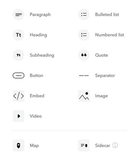
The heart of the new ArcGIS StoryMaps is the story builder, and its main feature is a block palette. In the block palette, you can find every element you need to assemble a narrative: regular paragraph text, headings and subheadings, story dividers, quotes, maps, images, videos, and more.
The block palette includes some special items that you should find particularly useful. You can use the embed block to insert web pages, Tweets, and other external web content, either as fully interactive items or as compact cards with titles, thumbnail images, and links.
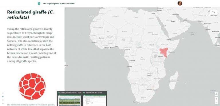
The sidecar block, the first of several immersive blocks added to the builder, combines a scrolling narrative panel on one side (accommodating text and multimedia items) with a stationary media panel on the other side to add a unique reading experience to your scrolling story. You can create a series of these pairs, or slides, within a sidecar block, resulting in an experience that closely resembles the classic Story Maps Journal template. Soon, you will see a block that emulates (and improves on) Story Maps Tour.
You can build your story, block by block, using the palette—and you can insert new blocks between the ones you’ve already created. All the while, your story is saved automatically, eliminating the risk that a browser crash or other mishap will result in lost work.
People are increasingly using story maps as a dynamic, easily updated alternative to Microsoft PowerPoint for giving presentations. With that in mind, Esri will soon introduce a new feature that will let you replace the vertical scroll of the current ArcGIS StoryMaps (and the classic Story Maps Cascade) with a horizontal scroll through a series of slides.
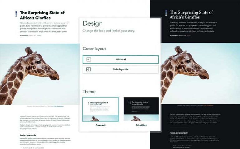
Yet another cool feature of ArcGIS StoryMaps is a design panel that lets you change the theme—the look and feel—of your story with a single click. Each theme has its own combination of colors, fonts, and basemaps. Initially the builder offers themes with a light background (Summit) and a dark background (Obsidian). In the future, new themes will be added. Capabilities will also be added to give you greater flexibility in customizing your stories to match your tastes and your organization’s visual style.
The new storytelling builder also makes editing and publishing easier and more flexible. You can create drafts and publish stories for your organization or the public. You can also make extensive edits to a published story. Your edits will be saved as unpublished changes until you’re ready to have them appear in the published story. As a final touch, the ArcGIS StoryMaps builder automatically generates a prepopulated panel or card, with title and thumbnail image, that appears in social media posts.
Remember—all these features will be available within a single builder. You’ll be able to mix and match them in fun and creative ways.
Incorporate Web Maps, Web Scenes, and Express Maps
Shame on me for coming this far having barely mentioned maps! Maps, after all, are what make Esri’s storytelling tools uniquely useful and powerful. ArcGIS StoryMaps lets you seamlessly integrate the web maps and 3D web scenes that you’ve created—or that you’ve discovered on ArcGIS Living Atlas of the World—into your narrative. Both will work beautifully within the new story maps, even on mobile devices.
ArcGIS StoryMaps introduces a new mapping alternative: express maps. With express maps, you can quickly create simple, beautiful maps featuring one or a series of points, lines, and areas. You can create pop-ups with images, titles, and descriptions, and you can add helpful annotations like text and arrows.
Storytelling for Everyone
Story maps have become a kind of lingua franca of the geospatial realm. ArcGIS StoryMaps will be even more useful for geospatial professionals and help make place-based storytelling easy and accessible for everyone. Students, researchers, designers, public affairs professionals, and hobbyists all want to tell stories, and they stand to benefit from a product that makes creating highly polished multimedia narratives easy.
These are challenging times. It’s more important than ever to use the tools of the digital age to inform the public about issues that affect the health and well-being of individuals, communities, and our planet. Story maps can play an important role in raising awareness; increasing understanding; inspiring people to action; and, ultimately, telling the story of the earth.
esri.com/storymaps
About the author