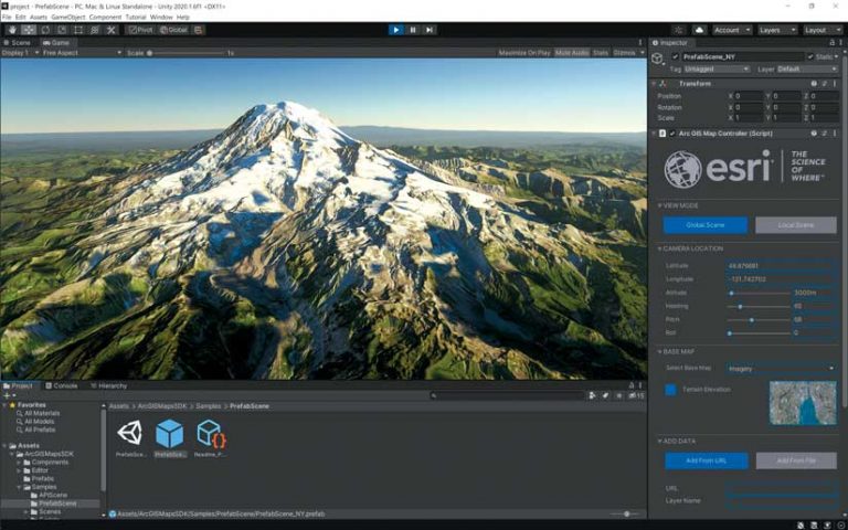
In October 2020, Esri announced a beta program for developers who want to use ArcGIS with game engines. This program hosts ArcGIS Maps SDK for Unity and ArcGIS Maps SDK for Unreal Engine. These products enable direct access to ArcGIS data and operations within a game engine.
Over the past few years, many industries and organizations have pursued next generation 3D GIS solutions. These solutions, which include client applications that target specific workflows, require a photo-realistic experience driven by real-world data.
These applications need to take advantage of high-end graphics capabilities on modern devices and utilize hardware designed specifically to support extended reality (XR) experiences. They also need to be highly interactive, visually compelling, and deeply immersive to increase engagement, improve understanding, and optimize the decision-making experience. Operationally, they need to support modeling and simulation scenarios and quickly render real-time geospatial information.
Many of these industries and organizations—most notably in the AEC, defense, natural resources, and transportation sectors—are using game engines to power photorealistic, interactive, and immersive 3D GIS applications. Game engines deliver high-performance, premium rendering experiences, and engaging special effects. The highly competitive nature of the gaming industry pushes the limits of game technology as well as its associated content and hardware.
Successful game engine vendors have spent years developing premium, high-definition rendering pipelines that deliver simulated world experiences, optimized for multiple platforms and form factors. The introduction of high-fidelity assets, physics engines, animation properties, and atmospheric, water, and other special effects has enabled game engines to deliver beautiful, photorealistic visuals that look and act like the real world.
Game engines also support a wide variety of desktop and mobile platforms and dedicated, specialized hardware. Part of the next generation of 3D GIS solutions will include the use of headsets, such as HoloLens, Oculus Quest, and HTC Vive, providing XR workflows in business settings. Game engines are built to support the responsiveness, frame rates, and fidelity needed to power these experiences.
To this end, the first beta release of the ArcGIS Maps SDKs integrate with the two market-leading game engines, Unity and Epic’s Unreal Engine. The ArcGIS Maps SDK for Unity and ArcGIS Maps SDK for Unreal Engine are available as plug-ins that provide direct access to ArcGIS services and data. Although the functionality delivered in both SDKs is equal, the capabilities of the editors and engines may differ.
To deliver the best experience possible, Esri is working with Unity’s geospatial team and Epic’s Unreal Engine development team to enable and optimize access to the Esri geospatial platform.
“As gaming technology is increasingly adopted in many industrial sectors including AEC, government, energy, and transportation, we are excited to partner with Esri to bridge the world of GIS and real-time 3D,” said Julien Faure of Unity Technologies. “The addition of Esri’s best-in-class real-world geospatial data into Unity’s real-time 3D development platform will help create real-time digital twins of an unprecedented scale, to better operate and manage massive infrastructure and entire cities in immersive environments.”

For software solution providers, Sébastien Lozé of Epic Games noted that “As the needs of the geo-intelligence community continue to grow, training, simulation, architecture, and urban planning projects are creating new challenges. Esri’s new plug-in for Unreal Engine will allow ArcGIS users to experience virtual environments in entirely new ways and will equip them to meet the ever-rising demand for innovation.”
Development in either editor is supported on Windows and macOS. Although both engines support developing apps for a variety of platforms, this first beta release only targets apps for Windows, macOS, Android, and iOS. Note that support for Windows includes 64-bit apps on desktops and 32- and 64-bit Universal Windows Platform (UWP) apps, which means Esri supports the use of apps with first- and second-generation HoloLens devices.
Both local and global experiences are available. Local scenes support display of geographic data on a planar surface and can work with different projected coordinate systems, which are usually appropriate for smaller, local areas. Global scenes support the display of geographic data on a sphere or globe, which is usually appropriate for large areas or regions. Other content, such as game objects and actors, can appear in these scenes, but this content must appear within the geographic coordinate space and the camera control established by the ArcGIS Maps SDK plug-in.
The ArcGIS data sources that are accessible by the plug-ins include single elevation service for terrain, multiple raster tile layers, and multiple 3D objects or integrated mesh scene layers.
Single Elevation Service for Terrain
This data source is an image service hosting Limited Error Raster Compression (LERC) encoded tiles with elevation values, which includes ArcGIS Online World Elevation services for terrain and bathymetry. [LERC is a highly effective raster data compression technology invented by Esri.]
Multiple Raster Tile Layers
This data source includes cached map or image data for display from an ArcGIS map service or a local tile package (.tpk file). Sources include ArcGIS Online basemaps with imagery, topography, or street data.
Multiple 3D Object or Integrated Mesh Scene Layers
These data layers are founded on i3S, an open specification optimized for the delivery and use of 3D data. 3D objects can include textured buildings and structures. Integrated mesh scene layers use a triangulated irregular network (TIN) to represent a continuous 3D surface that is usually acquired from satellite or aerial imagery. These layers can be delivered as scene services or local scene layer packages (.slpk files). Scene layers should be published with version 1.7, the latest version of i3S, because that version includes significant improvements to performance and memory usage.
Note that this first beta release will only support access to public ArcGIS services, not secured services. Esri plans to add support that will enable access to secured services in the next beta release.
In addition, built-in access to feature sources, such as ArcGIS feature services or mobile geodatabases, is not supported in the first beta. Esri will target support for these feature sources in a future release. However, a location component is provided for integrating custom content, such as game objects and actors, within the scene established by the ArcGIS Maps SDK plug-in. A developer can use this location component to craft a solution that retrieves feature geometry and attributes to display and use in a scene. The location component can be used to bring in a wide variety of content to participate within the scene.
Join the ArcGIS Maps SDK for game engines beta program. The beta program includes product downloads, links to product documentation, and access to forums.
About the author