2018–2022 Five-Year Census Estimates Available
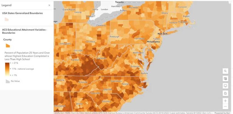
ArcGIS Living Atlas of the World has been updated with the newly released US Census Bureau American Community Survey (ACS) 2018–2022 five-year estimates. Available for free, these hosted feature layers eliminate the need for users to spend time downloading and processing new census data. These 112 layers can be mapped and used in analysis of ACS data at state, county, and tract levels.
Microsoft Fabric Will Include ArcGIS Spatial Analytics
The long-standing strategic collaboration of Esri and Microsoft has been extended with the inclusion of 140 ArcGIS spatial analytics tools and functions into Microsoft Fabric. Fabric, an artificial intelligence (AI)-powered analytics platform that unites data and services, is slated to be available in the second quarter of 2024. This integration will allow data to flow across organizations, whether users are working in Microsoft OneLake, Microsoft Power BI, or the ArcGIS environment. With this collaboration, Fabric users can directly access sophisticated spatial analytics tools and functions and an extensive library of authoritative and curated spatial data to produce interactive and intuitive visualizations and maps. Learn more at links.esri.com/fabric.
Get Answers to Your Tech Support Questions with an AI-Powered Chatbot
A new AI-powered chatbot makes it easier to get answers to simple and complex questions about ArcGIS technology. The Esri Support app enables users to connect with Esri Support through their mobile devices. Users can ask it questions about Esri products ranging from general ones like, “How do I create a layer in ArcGIS Online?” to more specific queries such as, “What causes Error 001624 in ArcGIS Pro?” and get answers in seconds. It supports 40 languages and responds in the language in which the query was made. While anyone can use the chatbot, users on support can submit a technical support ticket, follow the progress of bug fixes, keep tabs on patch releases, and get product life cycle information from the app. The Esri Support app is available in the Apple and Google Play app stores.
Autodesk Adds ArcGIS Basemaps and ArcGIS Living Atlas Data to Its Software
Autodesk and Esri, which have been collaborating since 2018, enhanced their relationship to further the interoperability of GIS and building information modeling (BIM) data to reduce costs and boost efficiency across construction projects. This agreement will integrate ArcGIS basemaps and ArcGIS Living Atlas of the World layers into Autodesk products so that communities can build more connected, resilient cities and infrastructure by designing projects in a real-world context.

Updated Teaching Tool for Exploring the World through Geography
Esri and the National Geographic Society have launched a new version of the National Geographic MapMaker, an online interactive mapping tool that empowers students, teachers, and others to explore the world through geography. Updates to MapMaker 4.0 reach beyond the scope of a traditional map and provide users with interactive data on a variety of important topics. This 2D and 3D app employs the latest GIS software, allowing users to visually experience and interact with geospatial information about Earth’s interconnected social and physical systems while also exploring the art of mapmaking.