Land mines and other explosive ordnances (EOs) are notoriously easy to manufacture and conceal. In addition, they are difficult to detect and remove, even when conflicts involving their use have died down. They not only hamper economic recovery and development in war-affected areas, but can also cut communities off from basic necessities, such as water and food supplies.
The Mine Ban Treaty, an international agreement prohibiting the use of antipersonnel land mines, was enacted in 1997, but according to Morgan Kline, roughly 60 million people in 60 countries still live with a daily risk of land-mine detonation.
Kline is the global information systems manager at Anti-Persoonsmijnen Ontmijnende Product Ontwikkeling (APOPO), a Tanzania-based organization that trains animals—primarily rats and dogs—to assist in tuberculosis outbreaks, initiatives to thwart illegal wildlife tracking, search and rescue operations, and, of course, land-mine detection.
“Our GIS-centric management for this lifesaving work has helped return more than 100 million square meters of previously contaminated land to local communities,” he said.
This work relies heavily on software such as ArcGIS Field Maps and ArcGIS Pro to track dogs’ movements and range of scent detection in a minefield. While APOPO has employed Esri technology since 2019, the organization has been expanding its capabilities to include tracking of the dogs’ physical condition and the impact of minefields on agricultural development using ArcGIS Dashboards.

Training and Implementation
APOPO began operations as an R&D facility in 1997, after obtaining grants from the Belgian government. Initially, the organization trained African giant pouched rats as scent detectors for land mines. Later, they added both Belgian and Dutch Shepherd dogs to their detection resources.
“Training a dog for land-mine detection is a fairly complicated process,” said Kline. “It takes between nine and twelve months and includes search path training—continuous search in a 25-meter lane through obstacles—and indication training—the exposure to explosive targets.”
The use of mine-detection dogs began during World War II. The training of both the dogs and their handlers was an extensive process that lasted several years. Those responsible for removing EOs had to first learn how to best develop a canine’s skills for detecting a buried item with very little scent that reached the surface. A dog’s natural keen sense of smell and the capability to quickly examine large swaths of uneven terrain are a good start, but need to be honed over time.
As part of APOPO’s training process, the dogs are also exposed to nontargeted items, known as discrimination training, and taught to work in changing environments.
Today, APOPO uses both rats and dogs in their operations, although dogs are more often used for mine detection. The animals complement each other in their detection efforts because of their relative size and capabilities. Canine breeds, for example, function better in dense foliage and are less susceptible to extreme temperatures than their rat counterparts. The trained animals and their handlers are in high demand and currently work in Ukraine, Cambodia, Angola, Azerbaijan, Senegal, and Argentina.

APOPO uses its canines mainly for technical survey, a key phase in confirming the presence or absence of land mines, and eventually determining the extent of the contaminated areas.
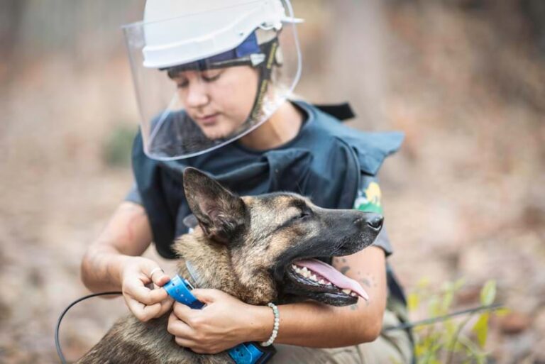
For track and trace operations, dogs are fitted with Garmin T5 collars, which collect GPS Exchange Format (GPX) files. These files are then converted to a polyline in ArcGIS Pro. A buffer is created around the line, indicating both the animal’s movements through the minefield and its range of scent detection. An analysis of the poly-line’s characteristics determines whether there are EOs on the land, or if it can be used by local residents.
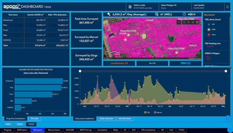
Information about a dog’s exploration of a designated area is presented in a dashboard created with ArcGIS Dashboards for analysis. This includes data from an ArcGIS Survey123 form, which records the animal’s daily progress, as well as EOs and other items it discovers. In addition, search obstructions and additional geographic features are recorded in ArcGIS Field Maps to complete the collection of data.
The ArcGIS environment allows APOPO to track the dog’s metrics, such as how long it works, when it signals a find, what explosive items it detects, and how many meters it covers. These working attributes for each dog are displayed via widgets in ArcGIS Dashboards. Mobile workers verify the results before EO clearance begins.

An Ongoing Process
APOPO continuously introduces new uses for ArcGIS technology. Recently, the organization added a health and welfare component to its GIS, allowing APOPO to track the location and well-being of each dog.
“With more than 300 working animals in the organization, ensuring the wellbeing of the animals is our primary concern,” said Kline. “Using Esri’s geospatial environment helps us monitor key components of our work and ensure compliance with the Government Accountability Office Working Dog Health and Welfare Act.”
Also top of mind is a project multiple years in the making called Minefields to Rice Fields. Created with ArcGIS Dashboards, this dashboard tracks agricultural development alongside land-mine clearance activities with map overlays used to correlate the farmland cleared for
selected planting.

APOPO has employed a rigorous registration system for those farmers participating in the program. Farmers are assigned QR codes used to validate their attendance at training and coaching sessions. APOPO also records the income earned by each farmer through participation in the project, allowing direct tracking of the program’s return on investment.
The work of the organization, its animals, and their handlers directly contributes to the safety and economic security of war-affected areas around the world, whether it is in the act of clearing mines or ensuring that the land is still viable after the fact.
“APOPO’s management team collectively represents more than 100 years of experience in humanitarian mine action,” said Kline. “We know what we want to see in our operational dashboards, what we want to highlight externally, and what we want to record and report. Our Esri-based reporting system allows for all of this and more.”

