Do you remember the Golden Rule?
It’s a simple premise learned in grade school: “Do unto others as you would have others do unto you.” Values like kindness, empathy, hope, and compassion are at the core of the Golden Rule. These principles guide humanity. And believe it or not, they can play a powerful role in the everyday work of geospatial technology researchers, technicians, practitioners, and businesses.
Citizen Science GIS, an international research organization at University of Central Florida, uses spatial thinking, Esri products, and drone technologies in its work with students in the United States and Central America, communities, local governments, and nonprofits. Its goal is to make science more accessible and understandable and ensure that society can inform science and benefit from scientific discoveries.
By implementing the Golden Rule, Citizen Science GIS believes that the geospatial technology user community can become more responsive to and inclusive of members of the general public who are interested in understanding the growing and exciting role of these technologies in their everyday lives. In the process, geospatial datasets can become more contextualized, more accessible, and more representative of local knowledge.
A Guiding Principle
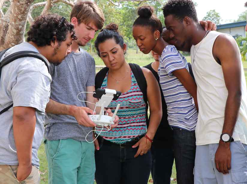
The Golden Rule became a major component of the work of Citizen Science GIS in Hopkins Village, Belize, during the summer of 2016. In this small fishing village of less than 3,000 people, a team of undergraduate students and faculty from the United States and Belize worked alongside community members. They examined flooding, beach debris, and coastal resiliency issues using ArcGIS Online, Esri Story Maps apps, Drone2Map for ArcGIS, Collector for ArcGIS, ArcGIS Desktop, and Survey123 for ArcGIS.
With a National Science Foundation grant and additional funding from the University of Central Florida and other supporters, the Citizen Science GIS team developed a community-based agenda to support local needs. The team interviewed community members including fishermen, families, tour guides, business owners, shop owners, resort managers, and government leaders. This work helped undergraduate students gain a glimpse into what it takes to do geospatial technology research in a setting that crosses cultures, values, and languages.
As the work began, it became clear to Citizen Science GIS that the Golden Rule would guide its use of geospatial technologies. The team emphasized the importance of including local, historical knowledge in GIS research about the village and nearby islands in Belize. Basic data about roads, parcels, land use, drainage, and flooding concerns were lacking at the village level. The village had no authoritative data in a GIS format that was accessible to either village council members or the general population.
Open Reef, a Citizen Science GIS project, is a research initiative that seeks to change the way science and society view vulnerable island environments around the world. It promotes exploration of these environments through drone mapping, open data, storytelling, and citizen science.
When the Citizen Science GIS work began in Hopkins, the message from the community members was clear: They wanted access to technology and data that supported their needs. They wanted to improve their community by having their knowledge captured using geospatial technologies.
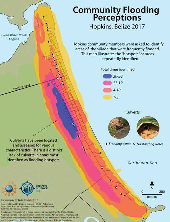
Citizen Science GIS valued the local knowledge that was captured through hands-on experiences with the technology and shared it through spatial storytelling. This approach was applied to the village’s first comprehensive study of flooding issues.
Because Hopkins is landlocked—with the Caribbean Sea to the east and a large lagoon to the west—flooding is a major concern for the community. The team went to residents and asked them to help map areas prone to flooding as well as drainage areas in their community using ArcMap, Survey123 for ArcGIS, and Collector for ArcGIS. The maps were created based on interviews with residents and clearly show areas of concern related to flooding and water flow.
Mapping flood data was just the beginning. The Hopkins Village Open Mapping Portal, a public mapping portal, was developed by local government and businesses, nongovernmental organizations (NGOs), and citizens to highlight local knowledge and the concerns expressed by community members.
The portal and the drone imagery captured by Citizen Science GIS are hosted on ArcGIS Online and provide access to basic data about flooding, culverts and drainage, street networks, and imagery for the village. These datasets differ from most of the larger proprietary or government-controlled datasets in that they were created by and with members of the local community, instead of being produced by a research or consulting team.
As Citizen Science GIS shared its science and research processes, something interesting happened. More people wanted to become part of the work and learn more about the power of geospatial technologies to address community challenges. Youth in the village, in particular, began to take a greater interest in the work.
The staff of Citizen Science GIS began working more closely with youth like one 12-year-old boy who woke up at 5 a.m. each day during his summer break to map beach debris and seaweed on the coast near his village. His dedication makes the Citizen Science GIS team hopeful that geospatial technologies can aid communities in addressing plastic pollution in the next few years.
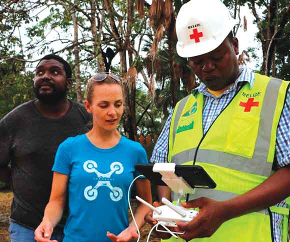
Citizen Science GIS also works with Belizean partners like Dirk Francisco, the local Red Cross representative and a tour operator in the village. Francisco, working with other community residents, has flown drones to map the village of Hopkins, vulnerable Mesoamerican reef islands, and coastlines. Their work demonstrates that communities can inform and lead the geospatial technology research needed to address climate change in Belize and share the lessons they learn with others.
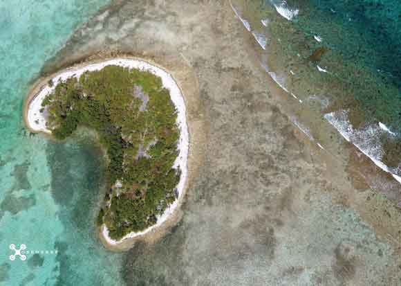
Some places in Belize are barely discernible in the satellite imagery that is freely available in online mapping platforms. The work with community members in the coastal village of Hopkins has led to new mapping opportunities in the Belize Barrier Islands, which are located just a boat ride east of the village.
Products like Drone2Map for ArcGIS, coupled with affordable consumer-quality drones, have allowed the team to literally put places back on the map for analysis. Over the last two years, Citizen Science GIS and partners in Belize have used affordable drones to completely change the way scientists and locals see more than 175 islands and coasts. This data, available on ArcGIS Online, can be located using the search term “Open Reef Belize.”
Getting More People Involved
As interest in the Open Reef project grew, other organizations, researchers, and community members have expressed interest in using drones to understand and document climate change impacts and island development. Beginning in late 2019, Open Reef will sponsor the Amazing Drone Race. The race is a 10-day citizen science mapping expedition in which as many as 10 boat teams will simultaneously use drones to map hundreds of islands in Belize over the span of 5 days. Teams will then spend an additional 5 days in Hopkins Village at an imagery summit to process, classify, and host all the imagery online for free in an open data mapping portal.
Why is Citizen Science GIS doing this? Because the team recognizes that collaboration, partnership, and serving humanity should be at the core of geospatial technology practices.

The Golden Rule Drives the Bus
The lessons learned in Belize applying the Golden Rule also drive the work of Citizen Science GIS in its home base in Florida, where it is building the nation’s first GeoBus. This 40-foot bus will be decked out with gear that will make it a mobile geospatial technology lab. Starting in 2019, the GeoBus will visit schools around Florida and cultivate a geospatial technology mind-set in more than 15,000 children each year.
As GeoBus drives around Florida, youth will engage in ArcGIS Online GeoInquiry lessons, fly drones and process the resultant imagery, use virtual reality goggles to view drone imagery, learn about topography in an augmented reality sandbox, engage in field data collection using Collector for ArcGIS on tablets, and use ArcGIS Pro to explore 3D drone image scenes captured in Belize and in other parts of the world.
GeoBus will provide a unique educational opportunity by showing children just how valuable they are as geospatial technology users and scientists. The Golden Rule underlies the work of Citizen Science GIS to empower Florida kids just as it does the group’s fieldwork in Belize.
A Hopeful Future for Geospatial Technologies
From youth explorers in Florida to fourth-generation fishermen on the Belize Barrier Reef, Citizen Science GIS believes the knowledge of local people is more valuable and accurate than data collected exclusively by nonlocal scientists, hence the organization’s emphasis on input by local citizen scientists.

Including the knowledge of everyday, extraordinary citizens represents the greatest growth potential for the geospatial industry and our greatest hope for solving the formidable social and environmental challenges facing society using geospatial technologies. As the geospatial technology industry rapidly expands, Citizen Science GIS will continue to emphasize people and apply the Golden Rule in all it does.
May all geospatial technology users continue to remember the importance of people and the Golden Rule in their work.