In March 2023, a global agreement of tremendous importance to the future of the ocean was signed. The United Nations (UN) High Seas Treaty, signed by 193 nations, marks the first step toward establishing policies to reverse biodiversity loss and ensure sustainable development. It creates a framework for protecting the high seas, an area that encompasses two-thirds of the ocean that is located outside of national boundaries and largely beyond most governance.
In the words of UN Secretary-General António Guterres, this treaty is “crucial for addressing the triple threats of climate change, biodiversity loss, and pollution.” This agreement is further evidence of a growing appreciation of the importance of ocean and the need to protect it.
A Little-Known and Underappreciated Realm
While the surface of the Earth, its moon, and even planetary neighbor Mars, have been mapped with a high degree of detail, just six years ago only 6 percent of the Earth’s seafloor was mapped to a comparable degree of detail. The ocean—which covers more than 70 percent of the Earth’s surface—has remained largely unexplored, barely mapped, and poorly understood.
Of all the plants, animals, and fungi found on Earth, a quarter of them live in marine environments. Scientists of the National Oceanic and Atmospheric Administration (NOAA) have estimated that 91 percent of species found in the ocean remain unclassified.
More important, the ocean’s contributions to the sustainability of the planet are greatly underappreciated. It is difficult to overstate the ocean’s importance. The wellbeing of the ocean is inextricably bound up with the world’s water supply. While only 2.5 percent of water on Earth is freshwater, the ocean stores of a vast majority of the planet’s water (96.5 percent) and provides evaporated water to the water cycle so that it can be circulated around the globe.
Called the world’s greatest ally against climate change, the UN states that the ocean generates 50 percent of the world’s oxygen while absorbing 25 percent of all carbon dioxide emissions and capturing 90 percent of the excess heat generated by those emissions. This carbon sink is a crucial buffer against climate change impacts.
The ocean also plays an increasingly important role in feeding the world. The nearly 10 million tons of fish caught annually significantly contribute to meeting the needs of a constantly growing population. According to the Food and Agriculture Organization of the United Nations (FAO), the global consumption of aquatic food has increased by more than five times over the last 60 years. The ocean is also the main method of transporting the world’s goods. Marine shipping carries approximately 80 percent of world trade.
Many Threats to the Ocean
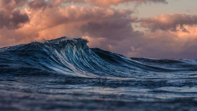
The well-being of the ocean and its inhabitants are threatened in many ways that include rising ocean temperatures, pollution, overfishing, and seabed mining. As concentrations of greenhouse gases have risen, the concentrations of heat at the sea surface and in the top 700 meters of the ocean and additional warming for the top 2,000 meters have increased overall during the past 30 years. With this temperature change have also come sea level rise, coastal land loss, and coastal flooding. Increases in carbon dioxide levels in the ocean have resulted in higher acidity levels in the ocean. Increased ocean temperatures and acidification both adversely affect marine species and ecosystems.
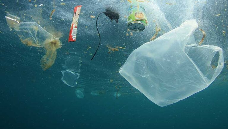
The ocean is assailed by many sources of pollution. Debris, from microplastics as small as 5 millimeters to abandoned fishing gear, is a highly visible form of pollution. The National Institutes of Health estimates that 10 million metric tons of debris are dumped into the ocean annually. Nonpoint pollution from sources, such as septic tanks, farming operations, timber harvesting, and manufacturing chemicals, are more difficult to measure. More easily identified, point source pollutions from events, such as oil spills, discharges from factories, or water treatments, are easier to identify but just as detrimental.
As the demand for food from the sea to feed a growing world population increases, unsustainable fishing practices are having a growing and negative impact. The International Union for Conservation of Nature and Natural Resources (IUCN) Red List of Threatened Species includes 1,550 species of marine plants and animals that are at risk of extinction. The State of World Fisheries and Aquaculture 2022, a report by the FAO noted that the percent of the fishery stocks fished within sustainable levels has decreased from 90 percent in 1970 to 64.6 percent in 2019. In addition, many more species are depleted by large-scale commercial fishing practices that inadvertently catch fish and other sea life that are discarded.
In recent years, commercial mining of seabed minerals is posing a new threat. Of 50 essential minerals, 37 of them are found in the ocean. One of the first deep mining projects is proposed for an area off Papua New Guinea, following several years of exploratory drilling. These excavation activities promise to be profoundly disruptive to marine life, ocean health, and the lives of those in the region who depend on the ocean for their livelihoods.
Esri and The Science of Where
During closing comments at the 2022 Esri Ocean, Weather, and Climate GIS Forum, Esri president and cofounder Jack Dangermond shared a little about the company’s founding. “Esri was started with this idea 53 years ago, not far from here, to basically build an organization in a very modest way that would apply rational thinking and science to environmental protection and land-use planning.”
Esri’s ongoing commitment to the environment and science has been summarized by Esri chief scientist Dr. Dawn Wright. “Science underpins everything that Esri produces. We’re very excited about all the things that we’re doing across all of the environmental sciences. This is embedded in what we do, to strengthen the foundation of our software and services; to research, publish, communicate, and serve alongside the scientific community; and to inspire positive change in society.”
Esri is engaged in efforts to further scientific research and preserve the ocean. In 2012, Esri hosted the inaugural Esri Oceans Summit, which brought together academic and research institutes, government agencies, nonprofit organizations, consultants, and ocean-related businesses that use GIS in the marine environment. This event kicked off the Ocean GIS Initiative, which has sought to increase the extent and quality of seabed mapping and improve support for multidimensional data and analyses.
In succeeding years, the event has evolved into the Esri Ocean, Weather, and Climate GIS Forum. Esri has contributed to the significant progress that has been made on the goals outlined in the Ocean GIS Initiative. It has combined the ocean basemap with the Esri’s world elevation services to develop a comprehensive land and sea service, supported development of vertical time-dependent data transformations, and enhanced the integration of numerical models.
Not only is science foundational to the development of Esri’s technology, but as an organization, Esri and Esri staff members are actively involved in scientific research. This includes participation in several programs that are part of an ambitious UN initiative dedicated to better understanding and preserving the ocean.
A Plan for the Ocean
Recognizing that threats to the ocean are escalating and the ocean plays an essential role in sustaining the Earth, the UN declared 2021 to 2030 the United Nations Decade of Ocean Science for Sustainable Development (Ocean Decade). The goal of this ambitious and wide-ranging plan is to move from “the ocean we need for the future we want” through developing ocean science that will provide a better understanding of marine ecosystems, inform policy to reverse its decline, and support actions for sustainably managing the ocean and achieving the UN 2030 Agenda for Sustainable Development. Through an alliance of scientists, resource providers, governments, businesses, and industries, the Ocean Decade Alliance hopes to revolutionize humanity’s relationship with the ocean.
Esri is participating in several Ocean Decade programs:
- Seabed 2030, led by the Nippon Foundation and the General Bathymetric Chart of the Oceans (GEBCO); and the promotion of Seabed 2030 and Ocean Mapping by the United States, which is led by NOAA
- Digital Twins of the Ocean (DITTO), led by the GEOMAR Helmholtz Center for Ocean Research Kiel and Kiel University
- The Deep Ocean Observing Strategy (DOOS), which is led by the Scripps Institution of Oceanography
- Early Career Ocean Professionals (ECOP), led by the Ocean Decade Informal Working Group for Early Career Ocean Professionals
- Esri is also a member of the Ocean Decade US Nexus, a program of the US National Ocean Decade Committee of the National Academy of Sciences that communicates news about US efforts related to the Ocean Decade.
Mapping the Ocean Floor
The Seabed 2030 Project was one of the first actions of the Ocean Decade. It is a global initiative to map 100 percent of the ocean floor to modern standards by 2030. When the project first launched in 2017, only 6 percent of the seabed was mapped. Seabed mapping supports the UN Sustainable Development Goal (SDG) 14: Life Below Water and is vital for the navigational security, safety, and economic health of countries around the world. A detailed knowledge of bathymetry is required to maintain the hundreds of thousands of square miles of cables that enable telephone communications, public and private data transmission, and the internet. The GEBCO digital map being built now covers more than 20 percent of the seabed, and research vessels are continually expanding the area mapped.
Esri, a partner in Seabed 2030, has been contributing to this project by promoting the project’s vision within the wider geospatial community. As a partner, Esri is involved in the collection of bathymetric data and sharing solutions developed for ocean mapping and bathymetric data management.
Digital Twins of the Ocean
Esri is part of a global network of 40 partners working on DITTO, a Ocean Decade program to make ocean data and information technology accessible to “all nations, stakeholders, and citizens.” To realize the program’s goal, Esri and its collaborators developed the Ecological Marine Units (EMUs), a 3D digital ocean model, which includes 50-year volumetric averages of ocean temperature, salinity, dissolved oxygen, and nutrients.
Digital twins of the ocean will provide a digital framework for marine data, modeling, and simulation that utilizes artificial intelligence (AI) and specialized tools for manipulating, analyzing, and visualizing marine information. This program is developing digital twins of the ocean that will be shared to support ocean science and asking what if questions when examining use cases and developing best practices and governance policies that promote sustainability. With a digital twin of the ocean, not only can the current ecosystem be more thoroughly understood, but its future state can be modeled based on scenarios such as the effectiveness of sea level rise mitigation efforts.
Telling the Story of Data
DOOS, which has been endorsed as an Ocean Decade program, is an international organization that coordinates the observation, exploration, mapping, and modeling of deep ocean baseline conditions and the effects of climate change and human disturbances. This information is essential to promoting a healthy, resilient, and sustainably managed deep ocean. DOOS also promotes early career researchers to aid them in developing into leaders in ocean science.
The overarching goal of DOOS is the promotion of a deep ocean community that spans disciplines and fields. Consequently clear, engaging, and meaningful communication that facilitates collaboration between members of the scientific community and translates scientific advancements to the public and policy makers is essential. The visualizations available in GIS via maps, dashboards, and ArcGIS StoryMaps help tell those data stories.
Implement DOOS (iDOOS), also an Ocean Decade program, seeks to build a network of networks that includes undergraduate institutions, as well as industries, nonprofit organizations, and governments across disciplines and communities related to the field of deep ocean observing (i.e., the ocean below 200 m depth). The project also funds six Early Career Researchers (ECRs) who are coleaders in each iDOOS working group. Esri chief scientist Wright is a coprincipal investigator on the iDOOS science translation working group. The entire project is run as a hub site using ArcGIS Hub.
Informing Action
In addition to its work on projects and initiatives associated with the Ocean Decade, Esri is working with the UN and other organizations around the world to build the geospatial infrastructure that will drive science and its application to address the world’s problems. It is only through better understanding of the ocean and its critical and complex role in the functioning of Earth’s systems, can both ocean and Earth be preserved.
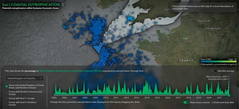
In partnership with GEO Blue Planet, the ocean and coastal division of GEO that connects information on the ocean and coastal areas with society, and the United Nations Environmental Programme (UNEP), Esri has created an index for coastal areas showing where excessive accumulation of plant nutrients cause eutrophication. Information on the potential for eutrophication in exclusive economic zones (EEZs) contained in this index is made available through the Coastal Eutrophication app. Information about the impacts of ocean pollution from land-based activities is now more accessible and can be used to support informed decision-making to help reach SDG 14.
OceanOPS, a joint center of the World Meteorological Organization (WMO) and the Intergovernmental Oceanographic Commission (IOC) of UNESCO, provides monitoring, coordinating, and integrating data services and metadata for a network of global oceanographic and marine meteorologic observing communities. The OceanOPS dashboard, built with help from Esri, makes available the data from the thousands of floats that monitor ocean and coastal conditions.
Balancing Sustainable Factors
In March 2023, Esri participated in the eighth annual Our Ocean Conference. The conference brings organizations together to ensure protection of the ocean through managing marine resources responsibly; growing sustainable blue economies and tourism; and creating marine protected areas (MPAs) where damaging activities are banned and marine life thrives.
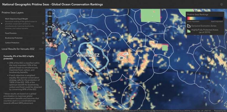
Since 2014, Our Ocean Conferences has attracted commitments worth approximately US$108 billion. At the 2023 conference, Esri announced a commitment with the National Geographic Society’s Pristine Seas to develop a web application that shows to new global conservation rankings that assess, monitor, and improve MPA management. For more than a decade, Pristine Seas has worked with local communities and governments to create 23 of the largest MPAs in the world. Learn more about the work of Dr. Enric Sala, a National Geographic Explorer in Residence, on Pristine Seas from this ArcGIS StoryMaps
There is no perfect solution to stop the loss of biodiversity, the depletion of food resources, or the release of greenhouse gases by oceans. Effective policies balance these requirements. Sala’s work has developed rankings of these factors to arrive at more equitable solutions. The web app, developed by Esri and Pristine Seas, will let policy makers weigh the tradeoffs between factors using tools that yield results that are easier to interpret.
Independently, Esri has created the Sea Level Rise ArcGIS Hub (sea-level-rise-esrioceans.hub.arcgis.com/) to make resources for understanding coastal flooding and sea level rise. This portal, which brings together apps, stories, and documents, was based on work Esri did creating the Climate Mapping for Resilience and Adaptation (CMRA) in 2022.
The Most Effective Approach Is a Geographic One
The ocean is fragile and is threatened by many forces. However, more than anything else, the ocean is threatened by our ignorance of it. Through its use of the geographic approach, GIS offers the best technology for gaining a more holistic understanding of this complex environment through the collection, analysis, and modeling of data about the ocean and the continued development of new research methods.
In dealing with the accelerating effects of climate change, Dangermond has said, “Time is not on our side, but technology is.” He believes that GIS professionals and scientists from different fields are creating information products that will affect the behavior of organizations. Using GIS, this information can be effectively shared between scientific researchers and communicated to policy makers and the public, enabling decisions that will help sustain the ocean and Earth.
About the author