Web mapping empowers transportation authority’s customers
Web mapping applications created by an Illinois regional transportation authority have made it much more responsive to requests from both internal and external customers and saved both time and money.
The Regional Transportation Authority (RTA) oversees three transit agencies in northeastern Illinois. Together, those agencies provide nearly 2 million rides per day, making it the third-largest public transportation system in North America. As the planning and financial oversight agency for Chicago Transit Authority (CTA), Metra, and Pace Suburban Bus, RTA warehouses planning and financial information for the northeastern Illinois transit system on a public-facing website called the Regional Transportation Authority Mapping and Statistics. The website now enables the public and affiliated agencies to perform geospatial analysis on corridor, demographic, and most transit-related data through various specialized browser-based map viewers.
Prior to the creation of its new digital system, each map request RTA received involved several time-consuming procedures. “Requests for mapping each senate district, or for maps of every house district, literally required at least a month of solid work,” said Brad Thompson, an RTA planner. Instead of ordering separate hard-copy maps of Chicago’s dozens of wards and districts, visitors can now go to an online map where they can interactively select a dataset, transit service, or jurisdiction and view it.
“Now, we’ll get a request in the morning, and I can publish one .mxd file by the afternoon,” said Thompson. “Visitors can run their own type of spatial analysis—and they don’t ever have to know what a shapefile is or how to open an attribute table.”
How did this happen? Although RTA had no dedicated full-time GIS staff, planners Thompson and Hersh Singh are experienced GIS users. However, they had little programming expertise.
Thompson attended the Esri International User Conference in 2010 to investigate software-based mapping solutions that required minimum coding skills. “After seeing a demo of ArcGIS API for Flex where an Esri staff member created an interactive map in minutes, I knew that was the solution for creating a browser-based map system to phase out RTA’s paper map production process,” said Thompson.
“The customizable appearance of Flex and the ability to easily add functionality with minimal coding inspired us to dive deep into it.” Within months, Thompson and Singh had created multiple browser-based applications that served the needs of internal transit staff and the public.
RTA’s web apps range from maps for identifying RTA-managed transit-oriented development studies to maps that display demographic data indicating an area’s potential to generate local transit trips based on transit trip rates. Serving this information on the web makes it possible for users to interact with data, allowing user-defined scaling, queries, and other functionality that would not be possible with static paper maps at fixed scales.
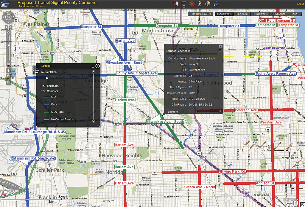
RTA can easily add and customize content and tools using ArcGIS Viewer for Flex. The default configuration includes tools and preconfigured templates for serving geospatial content in a browser-based viewer. Capabilities of an application can be extended by customizing the default widgets that are included or by using widgets that have been created and shared by the Esri community. These resources enable heat mapping, routing with directions and travel times, querying, editing, and exporting maps as JPEG files.
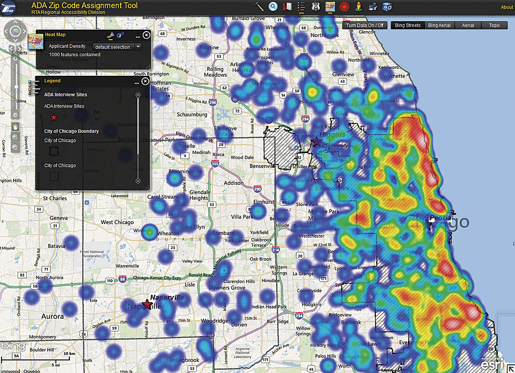
Since installing ArcGIS for Server and learning the ins and outs of Flex, Thompson and Singh have deployed numerous mapping applications that assist in the management of RTA programs. One of RTA’s mapping applications includes an Interview Site Assignment Tool used for assigning Americans with Disabilities Act (ADA) paratransit applicants within a ZIP Code to the nearest ADA site, where their ability to take fixed route transit services can be assessed.
Using an editing widget, staff can re-assign ZIP Codes to different interview sites based on applicant wait times to be seen for an appointment. Thus, the wait times at each of five interview sites is monitored, and, when necessary, ZIP Codes can then be reassigned to other sites to equalize wait times among all sites.
RTA also designed and deployed a Travel Training Trip Manager for ADA customers. This application greatly increases staff efficiency by combining several tasks in one easy-to-use mapping interface. The RTA Travel Training Program teaches individuals with disabilities and older adults how to use fixed-route buses and trains.
To evaluate if a fixed-route trip is an option, RTA staff go through a lengthy process of collecting information regarding the potential trip. The ADA Travel Trainer Trip Manager then provides a one-stop location for collecting all pertinent information in the evaluation of a potential fixed-route based trip. Once deployed, this application immediately resulted in increased travel training staff efficiency and productivity.
RTA will also soon deploy a mobile data collection and editing tool for managing interagency signage throughout the region. Based on ArcGIS Runtime SDK for iOS, the app will allow staff to add new sign locations using the device’s GPS as well as collect and edit attribute information in the field.
ArcGIS for Server has enabled RTA to serve many different geospatial datasets internally and externally. Now geospatial analysis is available to the public and staff without requiring they know anything about GIS.