Teaching GIS while learning about the past
This article describes how GIS students helped one of the authors with a genealogy project to trace the movements of his ancestors during the 19th century. Genealogists like to track the movement of ancestors across the land. Identifying when these people lived in specific places can reveal much about their daily lives. GIS techniques can provide a powerful tool for locating these places in space and time.
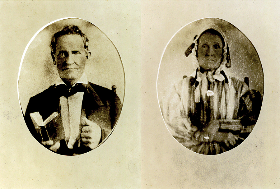
After retiring from teaching physics at Miami University in Oxford, Ohio, Glenn Julian (one of the authors) took up his father’s hobby of researching family history. Julian spent nearly 10 years in researching family records, history, and land records in county libraries and deeds recorded in county court houses. He learned that his great-great grandfather Isom Julian (1795–1885) and great-grandfather George Julian (1812–1906) moved from Rutherford County, North Carolina, to Blount County, Tennessee, about 1816.
Tennessee was formed in 1796 from the western part of North Carolina. Blount County was surveyed beginning about 1806 using metes and bounds. Julian learned that Isom and George continued moving southward into McMinn, Hamilton, and Bradley Counties as those counties were formed.
Adding GIS to the Search
Julian thought he knew approximately where the farms owned by his forebears were located (although that turned out to not always be true). He was intrigued by the thought of actually standing on the land. Because the land has not changed greatly in the intervening two centuries, he wanted to see the view that his great-great-grandma saw when she stepped out of the cabin door in the morning to feed her chickens.
At the suggestion of a faculty colleague, Julian contacted Robbyn J. F. Abbitt for assistance in locating the farmlands of his forebears. Abbitt advises Miami University’s GISci certificate program and teaches entry- and advanced-level GIS courses with a focus on real-world applications. In these courses, students use the most current version of Esri’s ArcGIS for Desktop software (Advanced license level). For advanced students, she provides instruction and coaches students in two types of assignments: semester-long GIS projects undertaken by an individual student or by a team of three or four students, who advise a client’s major GIS project. Over a period of three semesters, individuals and teams helped trace Julian ancestors in three Tennessee counties.

Historical Background
A series of treaties with the Cherokee opened up east Tennessee lands for legal settlement by people of European descent. Settlers were allowed to enter a claim for a tract. Upon paying an entry fee and occupying the tract, they were subsequently granted title to the claim by the state.
With the 1819 signing of the Calhoun Treaty, the US federal government bought a vast block of land known as the Hiwassee Purchase. The boundaries of the Hiwassee District included the Hiwassee, Big Tennessee, and Little Tennessee Rivers and enclosed McMinn and other counties.
Following the 1836 Treaty of New Echota, the Cherokee were removed from their last major block of lands in Tennessee. This area, known as the Ocoee District, extended to the border with Georgia and included Hamilton, Bradley, and other counties.
Both districts were surveyed in a public domain grid of six-mile-square townships that were further subdivided into 36 one-mile-square sections of 640 acres. Sections were further divided into tracts. A quarter section consisted of 160 acres.
The grid lines of the Hiwassee District paralleled lines of latitude and longitude. However—apparently to align somewhat with the Tennessee River—the Ocoee District was surveyed with a grid tilted at 20 degrees from the lines of latitude and longitude.
McMinn County Julians
A team of three GIS students worked with Julian to locate his ancestors’ claims in McMinn County, which is located in the southeast corner of Tennessee.
Julian’s great-great grandfather, Isom Julian, a circuit-riding Methodist Episcopal minister, was sent out as the first missionary from his church in Blount County. In 1833, Isom, his wife Betsey, two daughters, and four of their five sons moved to McMinn County. This was also the county where his father-in-law, Robert Patterson, had already entered a claim in 1825.
Isom’s claim was described in terms of the Hiwassee Survey as the southwest quarter of Section 32 of Township 4, Range 1 East (Section 32, T4 R1E) of the north-south Principal Meridian of the Hiwassee District, which passes about three miles east of Athens, Tennessee.
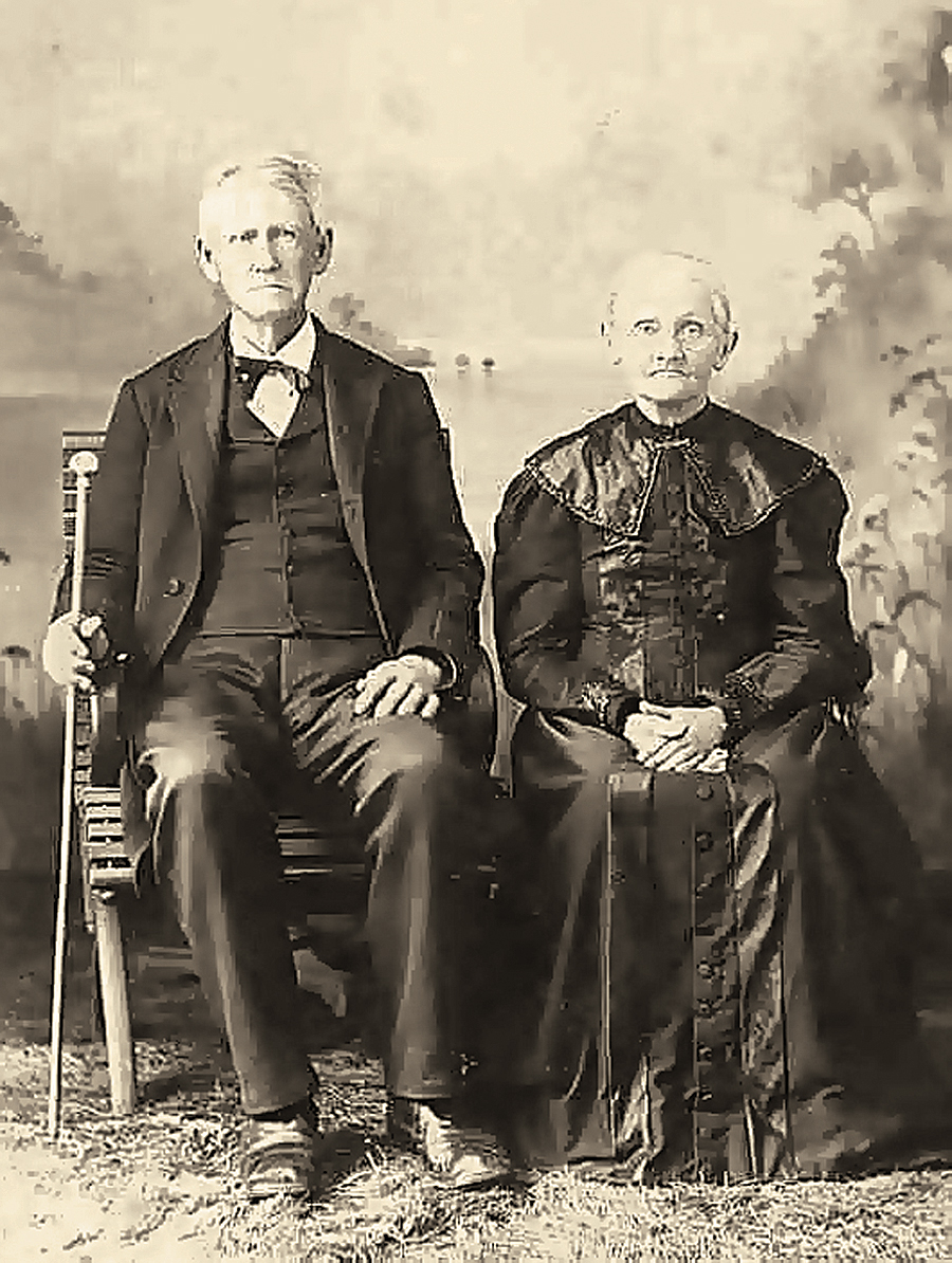
Julian identified the claim for the farm of Isom’s son George, who was also a circuit-riding minister. George established the claim when he married Mourning Smith in 1836. George’s son, Robert Patterson Julian, married a woman named Bond. Julian found earlier claims for both the Smith and Bond farms but could not find where they were located.
The only map he found that showed both the Hiwassee Survey grid and features on the ground today was a Cherokee National Forest map of 1994. This map was based on an 1851 hand-drawn map of the Hiwassee District. At the GIS office in the McMinn County courthouse, Julian was told that no accurate record existed of the location of the Hiwassee grid lines.
However, studying aerial images, such as Esri’s Online World Imagery basemap, revealed that the old survey lines are still visible on the ground as the borders of fields and woodlands. Although interrupted by later subdivisions, they extend for many miles in a checkerboard pattern. Pinpointing his forebears’ claims would require identifying these squares.
Abbitt’s GIS students worked with him to locate these claims. They used the Create Fishnet tool in ArcMap 10.1 to create a uniform grid of polygons that were one mile square. The students then adjusted this fishnet to match the section lines on the 1994 Cherokee National Forest map. By looking at current aerial images, students could infer the locations of claims in particular sections and townships as they were numbered in 1851. This led to the inferrence that Isom’s claim was located where, today, the town of Etowah, Tennessee, stands. However, this would have meant that his ancestors farmed on the side of a mountain—not a good place for subsistence farming.
Then Julian noticed that the 1825 claim by Isom’s father-in-law Robert Patterson was in T6 R1W. There was no T6 on the 1851 map. From the Tennessee State Library and Archives, Julian obtained a copy of the 1836 Tax Map for McMinn County. It showed that the numbering of townships in 1836 was different from the numbering in 1851 that was shown on the 1994 National Forest map.
After allowing for this discrepancy, students could identify the actual locations of the claims by Isom and George as well as those of James Smith and Peter Bond (whose children had married into the Julian family). All claims were six miles north of the previously identified sites. The claims were actually located on land suitable for farming and were laid out one to three miles apart, well within courting distance. Julian realized that he would not be here if Isom had chosen a different location for his farm.
Hamilton County Julians
A student used georeferencing and aerial imagery to locate land claims owned by George Julian and his brothers that were located in and near Tyner, Tennessee.
Between 1839 and 1842, George and his brothers, Samuel and Marsena, moved from McMinn County and entered claims for land newly opened for settlement in Hamilton County. These claims were in Fractional Township 5N, R3W of the Ocoee District meridian, which passed near Cleveland, Tennessee. As towns were formed in this area, Julian lands adjoined the towns of Tyner and Chattanooga.
Julian’s father inherited one of George’s original grant documents. At the Cleveland and Chattanooga libraries in Tennessee, Julian found microfilmed records of these land grants. From the Tennessee State Library and Archives, he obtained a map (circa 1842) of the grants, but unfortunately it did not show features on the ground.
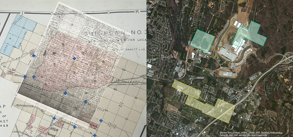
However a huge, rare 1928 plat book found in the Chattanooga Public Library included both the Ocoee Survey grid and modern features on the ground in the area. It is dramatically clear from the plats that today’s roads in Tyner follow the 20-degree tilt of the Ocoee District survey. A GIS student used ArcMap to georeference the old grant map to current road intersections in a digitized image from the plat book.
By 1850, George had sold his original grants north of Tyner and moved west of the Tennessee River. Most of the records of these transactions were lost after federal troops passed through the area following the nearby Battle of Missionary Ridge in November 1863. In 1858, George returned to the Tyner area. He bought land in downtown Tyner, where he lived during the war, moving to Bradley County in 1870.
The georeferenced reconstruction of George’s land in and near Tyner, superimposed on a current aerial image of the area, shows that the original grants of George and his brothers were located at the site of the new Chattanooga Volkswagen plant.
Bradley County Julians
A student team re-created portions of a survey grid in ArcMap to georeference the deeds owned by Julians who moved to Bradley county.
In about 1848, Isom and his son Robert Patterson Julian moved with their families from McMinn County to Bradley County in the Ocoee District. They settled in the Chatata Creek Valley northeast of Cleveland, Tennessee. Isom continued preaching, and his son, R. P., operated a water-powered sawmill. By 1870, both George and his brother, Samuel, had moved from Hamilton County to join them in Bradley County.
A team of three students read the locations of the Julian farms from copies or transcriptions of original deeds. An important lesson they learned is the deeds contained errors (a wrong quarter-section) and omissions (missing section numbers) that had to be corrected before the farms could be located. Bradley County tax maps from 1966 still noted the corners of Ocoee Survey Sections. The team used the Create Fishnet tool to re-create portions of the Ocoee District survey grid and georeference the deeds. They noticed that many modern property boundaries still reflect the Ocoee Survey grid lines.
Pedagogy
The Hamilton County study was the first one performed. It was carried out by an individual undergraduate student who was a botany major. The other two studies of McMinn and Bradley Counties used a team approach. Abbitt formed each team a few weeks into the semester after assessing the students’ GIS skills. Each team had at least one graduate student.
She had students play the role of professional consultants to a GIS client. Although she did not interact directly with the client, that did not necessarily save her time. The client understood that students were learning GIS techniques, but she also gave him an idea what the students were capable of doing.
The client, Julian, was a genealogist with no previous GIS experience. He attended some progress report oral presentations by the student working on the Hamilton County study to learn what the student could do with Esri software and gauge how well the student understood data on his family.
Students held one inaugural meeting with the client, worked out how they would share tasks, maintained e-mail contact with the client, and held a summary meeting with the client near the end of the semester before the final report and presentation to an audience. As with any team effort, students vary in motivation and participation, so Abbitt allowed both the client and teammates to provide some input on students’ grades.
This approach offers considerable promise because students will need to work in teams after graduation. GIS has grown tremendously over the past 10 years. Using these approaches exposes students to GIS techniques that they may not learn within a structured classroom setting. Thus far, the experience has been very positive for both students and clients. Many clients, like Julian, have been repeat customers.
Acknowledgments
Special thanks to the Miami University GIS students who worked on these projects: Joseph F. Lawrie, Lori Kelly, Daniel Pearlman, Jacob E. Young, Kelly Adelman, Michael Dennis, and Emma Troesch.
About the authors

Robbyn J. F. Abbitt